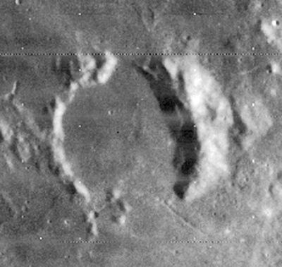
Sömmering
Contents
Sömmering
|
Lat: 0.1°N, Long: 7.5°W, Diam: 28 km, Depth: 1.32 km, Rükl: 32 |
Images
LPOD Photo Gallery Lunar Orbiter Images Apollo Images
- Although the names Sommering and Mosting (the pronounced crater immediately southeast of Sommering) are not mentioned in the LPI's search-list of orbital Apollo photographs, it (the craterpair Sommering and Mosting) was photographed by Apollo 16's mapping/metric Fairchild camera. The last eight frames of north-looking REV 27 (Revolution 27) show Sommering and Mosting near the curved horizon, as seen after local sunrise.
- Sommering and Mosting are also noticeable on Apollo 16's north-looking REV 37 (Revolution 37), from frame 1407 to frame 1416. Of these, frame 1411 shows the pronounced crater Mosting near the central part of the curved horizon, with Sommering nearby.
- Research orbital Apollo 16 photography: Danny Caes.
Maps
(LAC zone 59D4) LAC map Geologic map AIC map
Description
Description: Elger
(IAU Directions) SOMMERING.--An incomplete ring-plain, 17 miles in diameter, situated on the lunar equator. It has rather low broken walls and a dark interior.
Description: Wikipedia
Additional Information
Depth data from Kurt Fisher database
- Westfall, 2000: 1.32 km
- Cherrington, 1969: 1 km
Nomenclature
Samuel Thomas von Sömmering (28 January 1755 – 2 March 1830) was a physician, anatomist, anthropologist, paleontologist and inventor.
LPOD Articles
Bibliography
