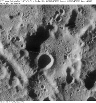
Reimarus
Contents
Reimarus
|
Lat: 47.7°S, Long: 60.3°E, Diam: 48 km, Depth: 3.05 km, Rükl: 68 |
LO-IV-184H The 29-km depression just below Reimarus is Reimarus A. The similar depression in the upper right is unnamed, as is the prominent 14-km diameter crater on the floor of Reimarus. The linear groove running into the frame at the lower left is the eastern terminus of Vallis Rheita.
Images
LPOD Photo Gallery Lunar Orbiter Images
Maps
(LAC zone 115D4) USGS Digital Atlas PDF
Description
Description: Wikipedia
Additional Information
- Depth data from Kurt Fisher database
- Westfall, 2000: 3.05 km
- From the shadows in LO-IV-184H, the west rim of Reimarus seems to have an irregular height ranging from about 2250-3370 m.
- Satellite crater Reimarus A is on the ALPO list of bright ray craters.
- Given that Reimarus A is the rather old, degraded crater straddling Reimarus' south rim, it seems likely that this is a misprint referring instead either to the unnamed young crater on Reimarus' floor, or (much more likely) to the fresh young and bright crater Reimarus H, located a short distance to the southeast. Reimarus H is small and bright enough to have served as a selenodetic control point. In the 1994 ULCN its position is listed as 49.240°S/62.217°E. - JimMosher
- Reimarus R a pre-Nectarian crater (Wilhelms, 1987)
Nomenclature
- Named for Nicolai Reymers Baer (c. 1550-c. 1600), a German mathematician.
- According to Whitaker (p. 224), this name was introduced by Schmidt.
LPOD Articles
Bibliography
Harold Hill. A Portfolio of Lunar Drawings, page 237.
