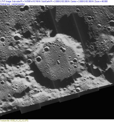
Gioja
Contents
Gioja
|
Lat: 83.3°N, Long: 2.0°E, Diam: 41 km, Depth: 1.63 km, Rükl: 4, Nectarian |
Images
LPOD Photo Gallery Lunar Orbiter Images
Location of Chesley Bonestell's Hayden moon mural (Lunar Landscape, 1957)
83° North/ 5° West (immediately west of crater Gioja) should be the location of the area depicted in Chesley Bonestell's moon mural Lunar Landscape which he made in 1957 for the Hayden planetarium in Boston.
  According to the mentioned online source, he positioned the viewer on a spot 1300 feet up the south wall of an imaginary lunar crater (“similar to Albategnius, but smaller”), located seven degrees from the moon’s North Pole (83° North) and five degrees to the left of the center of the lunar disc (5° West).
  There's a small printed version of this moon mural on page 66 of the Starlog Photo Guidebook SPACE ART by Ron Miller (1978).
  Research: Danny Caes
Maps
(LAC zone 1D1) USGS Digital Atlas PDF
Description
Description: Elger
(IAU Directions) GIOJA.--A ring-plain about 26 miles in diameter, near the north pole.
Description: Wikipedia
Additional Information
- Depth data from Kurt Fisher database
- Westfall, 2000: 1.63 km
- Based on the shadows in LO-IV-190H, the south rim rises by up to 1260 (on the west). The shadows cast by the north rim drop about 2150 m onto the floor of Byrd. - Jim Mosher
Nomenclature
- Named for Flavio Gioja or Gioia (fl. 1302), an Italian mariner and inventor. Gioja was a marine pilot who has been credited with perfecting the sailor's compass by suspending its needle over a fleur-de-lis design, which could be adjusted to point north. He also enclosed the needle in a box with a glass cover.
- Gioja was Catalog Number 1018 in Mary Blagg's Collated List and in the original IAU nomenclature of Named Lunar Formations, where the name is attributed to Beer and Mädler.
LPOD Articles
Bibliography
