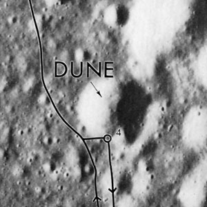
Dune
Contents
Dune (Apollo 15 site craterlet name)
(Apollo 15 landing site name)
|
Lat: 26.0°N, Long: 3.7°E, Diam: 0 km, Depth: km, Rükl: 22 |
Apollo 15 Site Traverses Chart
Images
LPOD Photo Gallery Lunar Orbiter Images Apollo Images
AS15-87-11767 and AS15-87-11768 show a curious lightbluish-colored boulder at the rim of Dune crater (Station 4). Note the boulder's large cavities. - DannyCaes Jan 21, 2008
Maps
(LAC zone 41B4) LAC map Geologic map LM map LTO map Topophotomap
Description
Dune is the southwestern member of the South Cluster (an irregular cluster of shallow depressions on the Plain north of Mount Hadley Delta). Maybe it is possible to observe the South Cluster through very powerful telescopes, or make digital photographs of it (telescope-attached webcam and very good seeing conditions).
Description: Wikipedia
Dune (correct link)
Additional Information
The Landing Site Name "Dune" is plotted on Topophotomap 41B4/S1 .
Nomenclature
Astronaut-named feature, Apollo 15 site.
LPOD Articles
Bibliography
Kenneth F. Weaver: Apollo 15 explores the mountains of the moon (National Geographic, February 1972).
  David M. Harland: EXPLORING THE MOON; The Apollo Expeditions.
  Eric M. Jones: APOLLO LUNAR SURFACE JOURNAL (ALSJ).
