Dorsum Higazy
Contents
[hide]Dorsum Higazy
|
Lat: 28.0°N, Long: 17.0°W, Length: 60 km, Height: km, Rükl: 21 |
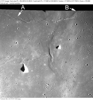
AS15_M-1692 According to the labeling on LTO-40B4, Dorsum Higazy appears to be the ridge extending from “A” to “B”, a distance of about 66 km. The ridges below it (closer to the center of the frame) are parts of a separately-named ridge system (Dorsa Stille).
Although the two depicted peaks (hillocks) are not named in the IAU system, in certain lunar atlases they seem to have been called Lambert Gamma and Lambert Delta (Lambert Gamma is the "nose"-shaped one at left, Lambert Delta is the small one at right). One might consider these two hillocks as the "guards" of Dorsum Higazy.
Images
LPOD Photo Gallery Lunar Orbiter Images Apollo Images
Dorsum Higazy was also captured on Apollo 17's orbital panoramic ITEK-camera frames AS17-P-3067, 3069, and 3074. To see Dorsum Higazy on these three frames, scroll rightward toward their right margins. Hillock Lambert Delta is also noticeable.
Additional research orbital Apollo 17 photography: Danny Caes
Maps
(LAC zone 40B4) LAC map Geologic map LTO map
Description
Description: Wikipedia
Additional Information
Nomenclature
Riad Abdel-Megid; Egyptian Earth scientist (1919-1967).
- Dorsa Higazy was among the many provisional dorsa names appearing on NASA’s LTO charts that were approved by the IAU “as now assigned and printed” (on those charts) in IAU Transactions XVIB.
- The position and diameter given for Dorsa Higazy in the on-line IAU Planetary Gazetteer (and repeated on the title line of this page) is biased a bit towards the “B” end of the ridge in the Apollo 15 view reproduced above.
- The peak in the lower left in the Apollo 15 view was provisionally labeled Mons Undest on LTO-40B4. This is an Invalid Name since the IAU never accepted it. - Jim Mosher
LPOD Articles
Bibliography
