Berlage
Contents
Berlage
| Lat: 63.2°S, Long: 162.8°W, Diam: 92 km, Depth: km, Rükl: (farside) | |
Images
LPOD Photo Gallery Lunar Orbiter Images Apollo Images
- Note: Berlage would be found in Lunar Orbiter LAC 133 of the USGS Digital Atlas, however, as this LAC is currently under construction (as of 24 June 2009 at time of writing), updates should be checked for. - JohnMoore2
Maps
(LAC zone 133D4) USGS Digital Atlas PDF
Description
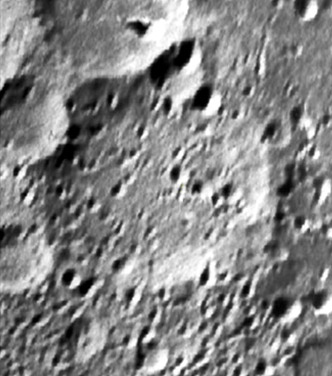
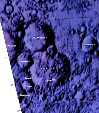
Berlage lies close in the central regions of the South Pole Aitken Basin (SPA-B) -- a 2500 kilometre-wide basin of the pre-Nectarian period (~ 4.6 to 3.92 bn years) whose centre is approximately at 54.2S, 168.7W. Berlage is barely perceptable in the left image above, where it lies amongst the more fresher-looking craters, Bellingsgauzen (Bellingshasen - 63 km) of the Nectarian period (~ 3.92 to 3.85 bn years) to the north, and Cabannes J (34 km) to the northwest -- both of which have had some damaging effect on Berlage's north-western rim. Numerous small craters ranging from 5 to 10 kilometres across cover most of its floor, with some larger ones ranging from 10 to 20 kilometres across in the north-eastern section of its rim. Because of Berlage's central location to SPA-B, the mare material on which it lies has gone through a transition in material from flat floor to a rise in its rim. - JohnMoore2
Description: Wikipedia
Additional Information
Nomenclature
- Hendrik Petrus; Dutch geophysicist, meteorologist (1896-1968).
  - Satellite crater Berlage R was erroneously printed as BERALGE R on LAC 142, page 285 in the REVISED AND UPDATED EDITION of the Clementine Atlas of the Moon, 2012, CAMBRIDGE UNIVERSITY PRESS.- DannyCaes Jan 10, 2013
LPOD Articles
Bibliography

