Bear Mountain
Contents
Bear Mountain (Apollo 17 site hillock name)
|
Lat: 20.0°N, Long: 30.7°E, Diam: 0 km, Depth: km, Rükl: 25 |


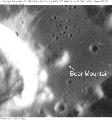
Left: Detail from AS17-M-1501 (the large crater to the east-northeast of Bear Mountain was called MOCR; Mission Operations Control Room).
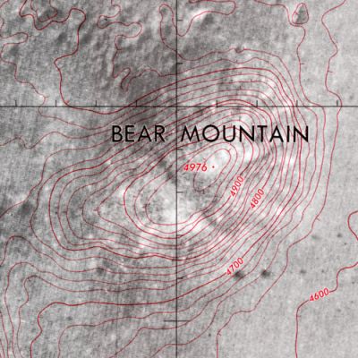
Right: Detail from Topohotomap 43D1S1
Images
LPOD Photo Gallery Lunar Orbiter Images Apollo Images
- HiRes scan of Lunar Orbiter 4's photograph LO4-078-h3 which shows the whole of the Taurus-Littrow valley with Bear Mountain in it (near the lower margin of the frame).
- Apollo 17's orbital photograph AS17-147-22464 shows the distant Command/Service Module (CSM) America immediately in front of Bear Mountain.
- Apollo 17's surface photograph AS17-145-22165 shows astronaut Jack Schmitt with Bear Mountain rightward of him, and East Massif at left.
- Well-known photograph AS17-140-21496 shows Jack Schmitt near Tracy's Rock, with Bear Mountain in the distance, just above the top of the boulder. East Massif at left.
- Research Lunar Orbiter 4 and Apollo 17 photographs: Danny Caes
Maps
(LAC zone 43D4) LAC map Geologic map LTO map Topophotomap 43D1/S1 Site Traverses chart 43D1S2
Description
"Bear Mountain" is a Landing Site Name.
- Bear Mountain - "Named because of its shape and because of its resemblance to a mountain of the same name near Silver City, New Mexico." Jack Schmitt grew up in Silver City (source: APOLLO LUNAR SURFACE JOURNAL, Eric M. Jones).
Description: Wikipedia
Additional Information
- Bear Mountain is a very good "first target" for every dedicated lunar observer who want to search for small details in the Taurus-Littrow valley, and to observe (or to photograph) these details (such as Bear Mountain) through common and/or powerful telescopes.
- East-northeast of Bear Mountain is the location of the MOCR, which is the largest one of the small craters on the floor of the Taurus-Littrow Valley.
- MOCR is NASA's abbreviation for Mission Operations Control Room.
- Research Danny Caes
Nomenclature
Astronaut-named feature, Apollo 17 site.
- From the air this relatively low hill apparently resembles a bear walking to the southwest, with a triangular head and ears visible in AS17-M-1501.
- Before Apollo 17's little hill in the valley was called Bear Mountain there was another Bear Mountain at the equatorial zone of the southern part of Mare Tranquillitatis. The source (or sources) of the name Bear Mountain (which might have been Maskelyne Alpha) was (or were) the mapmaker(s) for NASA's early Apollo lunar missions (Apollo 8, 10, and 11).
LPOD Articles
Bibliography
- Harland, David M. Exploring the Moon; the Apollo expeditions (Springer, 1999).