Apollo 16 Site
Contents
[hide]Apollo 16 Site
(unofficial name)
|
Lat: 8.97301°S, Long: 15.50019°E, Diam: 0 km, Depth: km, Rükl: 45 |


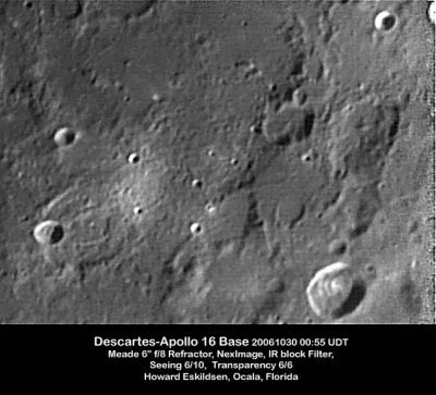
Left: Howard Eskildsen
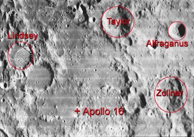
Right: Apollo 16, Zollner, annotated by LPI
Images
LPOD Photo Gallery images Lunar Orbiter Images Apollo Images ASU Apollo Image Archive
Mike Constantine's assembled panorama of Apollo 16's landingsite shows LM Orion in front of Stone mountain. Looking south.
Discovery of planet Venus' appearance on surface photographs made by LMP Charlie Duke.
Dominique Caudron, a contributor of Eric M. Jones' Apollo Lunar Surface Journal (ALSJ) notes that LMP Charles Duke caught Venus just over the eastern horizon in AS16-117-18815 to 18817. At the time Charlie took the pan, 1904 GMT/UTC on 23 April 1972, the Sun's azimuth and elevation were 80.5 and 46.9 degrees respectively, and Venus's were 84.2 and 2.3 degrees. A vertical slice shows shadow orientations in the foreground. Venus rose at the Descartes landing site about five hours early but it was hidden by hills in the east from both Stations 11/12 and 13.
(source: E.M.Jones' ALSJ).
The tracks of the LRV around the landingsite of Apollo 16's LM Orion could be investigated at LON: 15.501 / LAT: -8.978 (0.5 M/PIX) in the LRO's ACT-REACT Quick Map. - DannyCaes Jun 26, 2011
Maps
(LAC zone 78D2) LAC map Geologic map LM map LTO map Landing Site Topophotomap Site Traverses Map
USGS Geologic Map of the Descartes Region (I-748 A)
USGS Geologic Map of Part of the Descartes Region (I-748 B) (the landing site of Apollo 16).
Description
Apollo 16 landed in a highlands region just north of the crater Descartes.
Description: Wikipedia
Additional Information
- The position of the Apollo 16 landing site given in the title line is from Davies and Colvin, 2000. It is based on the later measured position of the Apollo 16 lunar surface experiment package (ALSEP) radio transmitter and the assumption that the lander touched down 62 m east and 69 m north of that location. The measured ALSEP location is itself probably uncertain by at least 30 m. The position plotted on the earlier DMA-prepared Topophotomap was 8.9806S, 15.5078E. The difference between the coordinate values (corresponding to an offset of about 330 m) represents a change in what is thought to be the correct coordinate system, and not a change in the estimate of the landing position relative to the lunar features.
- The curious pair of high-albedo craters called North Ray and South Ray(near Apollo 16's landing site) is an easy target for those who observe the lunar surface through common and/or powerful telescopes, especially during Full Moon. Four nearby craters about the same size as North Ray, called Gator, Kiva, Palmetto, and Ravine (also in the neighbourhood of Apollo 16's landing site) are perhaps observable too! All four of these craters have low albedo, and should only be observed after local sunrise or before local sunset (shadows on the inner slopes of the craters). Research Danny Caes.
- NASA has selected the area explored by Apollo 16 as a Region of Interest for investigation for a possible return visit in connection with its Constellation program of exploration.
- Sample 64501 - see also Liu, Y. et al, Oct 2012 reference (to regolith and surface water) in Bibliography below.
- John W. Young (1930 - 2018) - the ninth astronaut to have walked on the moon (Apollo 16, 1972).
Nomenclature
The IAU Nomenclature includes 19 minor astronaut-named landing site feature names associated with Apollo 16 (copied from IAU Transactions XVIB):
- Smoky Mountains: Mountainous mass north of the landing site.
- Stone Mountain: Mountainous mass south of the landing site.
- Baby Ray: A small rayed crater atop bright rays of a larger crater.
- Cinco: A group of five craters ("cinco" is "five" in Spanish) on the foothill of Stone Mountain in the vicinity of the southern-most portion of the second EVA traverse.
- Spot: Two overlapping craters that served as a landing landmark. The LM landed about 100 m north of the craters (also called Double Spot).
- End: End for being the last planned stop on the last EVA.
- Flag: Sampling site of Station number 2 on the rim of Plum.
- Gator: Large crater named for alligator.
- Halfway: Crater centrally located between sampling sites 1 and 2.
- Kiva: Crater named after the Pueblo Indian architectural structure which is usually round.
- North Ray: One kilometer diameter bright-rayed crater north of the landing point. The ejecta and rim of the crater were sampling sites number 11 and 13.
- Palmetto: A crater, one kilometer in diameter, named after the palm tree of the same name.
- Plum: Large crater with Flag on the rim.
- Ravine: A large irregular depression on the base of Smoky Mountains, part of which appears much like a ravine, a small narrow, steep-sided valley.
- South Ray: One kilometer diameter bright-rayed crater south-southwest of the landing point. Ray materials from this crater were collected at several locations in the landing site area.
- Spook: A crater that is one-half kilometer downrange from the landing spot. The crater's location represented a hazard and worried the crew during the preparation and training for the mission. Sampling station number 2 was on the rim of this crater.
- Stubby: A crater, one kilometer in diameter, with a stocky and thick protrusion from Stone Mountain. Sampling station 6 is on the north rim of this crater.
- Trap: An old, subdued and partly hidden depression that hindered planning a southwesterly traverse to sample and study Baby Ray.
- Wreck: Sampling station number 8; a relatively old crater whose original features appear disordered and ruined by later events. The crater is located between Stubby and Trap. All three craters were used as landmarks for LM landing.
The landing site itself has no official name.
Other names of surface features in the neighborhood of Apollo 16's landing site (not recognized by the IAU)
- Buster (small craterlet immediately north of Spook)
- Cat (small craterlet immediately southwest of Ravine), should be seen as C.A.T. (LMP Charlie Duke's sons Charles-And-Thomas)
- Crown (small craterlet south of the Cinco cluster, upward on the slope of Stone Mountain above the Cincos). Crown was captured in photographs AS16-112-18201, AS16-112-18216, AS16-105-17064
- Dakota (shallow depression west of Palmetto)
- Dot (small craterlet immediately north of Palmetto and End)(probably named by Charlie Duke, for his wife Dotty)
- Eden Valley (shallow depression southwest of Spook)
- House Rock (the largest rock visited by an Apollo crew, on the southeastern part of North Ray Crater's rim)
CDR John Young and House Rock in the distance: AS16-106-17336
- Ivy (craterlet west of Palmetto)
- Lone Star (small craterlet immediately east of Gator)
- Merriam (small craterlet southwest of Sunset)
- Red Rose (shallow crater south of Spook)
- Shadow Rock
Shadow Rock: AS16-106-17393
David Harland's assembled panorama of Station 13 at Shadow Rock
CDR John Young in the shadow of Shadow Rock: AS16-106-17413
- SP (small craterlet south-southeast of Red Rose)
- Sunset (small craterlet southeast of SP)
- Survey Ridge (shallow depression east of Sunset)
- WC (small craterlet south of Apollo 16's landing spot)
Source of this list: pages 201, 222, and 226 in David M. Harland's Exploring the Moon; the Apollo expeditions (Springer, 1999).
Unofficial names which are not mentioned on the photographic maps in David M. Harland's book (see pages 201, 222, and 226)
- Big Depression (shallow depression southwest of Gator)
- Big Sag (small depression between LM Orion and Palmetto)
- Big Sink (shallow depression south of North Ray Crater and east of Kiva)
- Cove (shallow depression north of Trap)
- Dogleg (northeast of Palmetto)
- Doodlebug Hole (another name for the small depression between LM Orion and Palmetto)
- Double Spot (see the official name Spot)
- Haystack (a North Ray sized crater west of the landing site) (see the LROC article Astronaut's Eye View of Apollo 16 site)
- Phantom (small shallow depression south-southeast of LM Orion's landing site)
- Turtle Mountain (a slight elevation between Palmetto and Spook)
Source of this list: several maps in Eric M. Jones's online Apollo 16 Lunar Surface Journal
Unofficial names which were printed on the USGS's Geologic Map of Part of the Descartes Region of the Moon, I-748 B (which also shows Apollo 16's proposed landing site)
- Big Sag (west-northwest of North Ray Crater)(not related to the other Big Sag between LM Orions site and Palmetto, see list above)
- Canoe (west-northwest of North Ray Crater and Big Sag)
- Descartes Mountains (northeast, east, and southeast of LM Orions landing site)
Marcus Gerhardt Langseth
It would be interesting to add the name Langseth to one of the officially unnamed craters in the neighbourhood of Apollo 16's landing site, because M.G.Langseth was one of the scientists who played an important role during the mission of Apollo 16 (the study of the lunar surface's heat flow).
  See also the ALSJ page for Marcus Gerhardt Langseth, 1933-1997.
 - DannyCaes Nov 12, 2011
LPOD Articles
What is the Descartes formation?
LROC Articles
First LROC Stereo Results (South Ray Crater).
Apollo 16, Footsteps Under High Sun
Orion, Up Close
Astronaut's Eye View of Apollo 16 Site (this article shows an "extra" crater name: Haystack, west of Apollo 16's site).
How Young is Young? (North Ray Crater and House Rock).
Bibliography
- Day, J. M. D. et al (2017). Late-stage magmatic outgassing from a volatile-depleted Moon – PNAS, doi: 10.1073/pnas.1708236114. Published online 21 August, 2017.
- Liu, Y. et al (2012). Direct Measurement of Hydroxyl in the Lunar Regolith and the Origin of Lunar Surface Water (PDF introductory) – Nature Geoscience, Vol 5, No 10, DOI:10.1038/ngeo1616. Published 14 Oct, 2012.
- Chi, P. J. et al (2011). Restoration of Apollo Magnetic Field Data: Accomplishments and Outstanding Issues – 42nd LPSC Conference (Mar), 2011.
- Dawson, M. D. et al (2011). Apollo Lunar Sample Integration into Google Moon: A New Approach to Digitization – 42nd LPSC Conference (Mar), 2011.
- Isaacson P. J. et al (2011). Reflectance Spectroscopy of Ilmenite: New Constraints from Apollo Sample Measurements – 42nd LPSC Conference (Mar), 2011.
- Kong, W. G. et al (2011). Ti Distribution in Grain-Size Fractions of Apollo Soils 10084 and 71501 – 42nd LPSC Conference (Mar), 2011.
- Kim, T. et al (2011). Robust Orbital Refinement of the Apollo Trajectory Data for the Ames Stereo Pipeline – 42nd LPSC Conference (Mar), 2011.
- Moratto, Z. et al (2011). Stereo Reconstruction from Apollo 15 and 16 Metric Camera – 42nd LPSC Conference (Mar), 2011.
- Petro, N. E. et al (2011). Digitization and Reanalysis of Apollo Surface Traverses – 42nd LPSC Conference (Mar), 2011.
- Lofgren, G. E. et al (2011). Apollo Lunar Sample Photographs: Digitizing the Moon Rock Collection – 42nd LPSC Conference (Mar), 2011.
- Williams, D. R. et al (2011). PDS Lunar Data Node: Restoration of Apollo Surface and Orbital Data – 42nd LPSC Conference (Mar), 2011.
- Apollo 16 Lunar Surface Journal (Eric M. Jones).
- EXPLORING THE MOON; The Apollo Expeditions, by David M. Harland (Springer, 1999).
- Head, JW (1974). Stratigraphy of the Descartes region (Apollo 16): Implications for the origin of samples. Moon 11, 77-99.
- APOLLO OVER THE MOON; A VIEW FROM ORBIT, Chapter 2: Regional views, Figure 24. Chapter 3: The Terrae (Part 2), Figures 46 and 47.
