Stevinus
Contents
Stevinus
|
Lat: 32.49°S, Long: 54.12°E, Diam: 71.54 km, Depth: 3.82 km, [/R%C3%BCkl%2069 Rükl: 69], [/Stratigraphy Copernican] |
Table of Contents
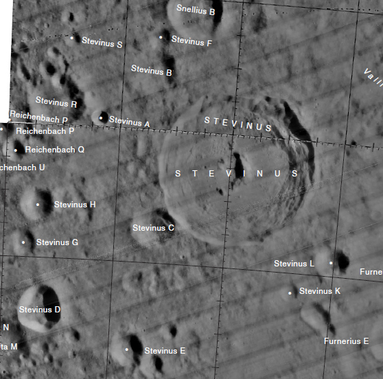
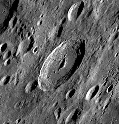
Left: LROC WAC image – found in the WAC mosaic here.
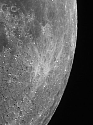
Right: Eric Soucy, Stevinus and [/Furnerius Furnerius], with the pair of high-albedo raycraters Furnerius A and Stevinus A, sometimes called the Headlights.
Images
LPOD Photo Gallery Lunar Orbiter Images Apollo Images
Lunar Orbiter 5's Frame 040 shows a close-up of Stevinus, captured near the lower-left corner of the photograph.- DannyCaes DannyCaes Mar 23, 2008
Maps
([/LAC%20zone LAC zone] 114B2) LAC map Geologic map
Description
Elger
([/IAU%20Directions IAU Directions]) STEVINUS.--A somewhat larger ring-plain, S. of [/Snellius Snellius], with a border rising on the S. to more than 11,000 feet above a dark interior, which includes a bright central mountain.
Wikipedia
Additional Information
- IAU page: Stevinus
- Depth data from [/Kurt%20Fisher%20crater%20depths Kurt Fisher database]
- Westfall, 2000: 3.82 km
- Cherrington, 1969: 4.69 km
- The Japanese spacecraft Hiten - Hagoromo crash-landed southeast of Stevinus (34.3° South/ 55.6° East, April 10 - 1993) and reportedly caused a brief effect visible in the infrared during the daytime. Svenhem (2006) !st International Conference on Impact Cratering in the Solar Syste. ESTEC, Noordwijk.
- [/Radar%20bright Radar bright] at 70 cm.
- [/Central%20peak%20composition Central peak composition]: GNTA2, AG, AGN & AN ([/Tompkins%20%26%20Pieters%2C%201999 Tompkins & Pieters, 1999])
- Stevinus and its satellite crater Stevinus A are on the [/ALPO%20list%20of%20bright%20ray%20craters ALPO list of bright ray craters], but... only Stevinus A is rayed! (C.Wood).
- Central peak height
- [/Sekiguchi%2C%201972 Sekiguchi, 1972]: 2.4 km measured from the west. A small mound to the SW of the central peak measures 1.2 km - fatastronomer fatastronomer
- TSI = 30, CPI = 25, FI = 20; MI =75 [/Smith%20and%20Sanchez%2C%201973 Smith and Hartnell, 1973]
Nomenclature
- Simon Stevin (1548/49 – 1620) was a Flemish mathematician and engineer. He was active in a great many areas of science and engineering, both theoretical and practical. He also translated various mathematical terms into Dutch, making it the only European language in which the word for mathematics ('wiskunde') was not derived from Greek (via Latin).
The Headlights
- The pair of high-albedo raycraters Stevinus A and Furnerius A are sometimes called the Headlights, see page 20 in the 21st Century Atlas of the Moon by Charles Wood and Maurice Collins.
LROC Articles
- Dry Debris or Liquid Flow? (In Stevinus A)
- Pancakes in a Melt Pond
LPOD Articles
Lettered craters

Graphic LAC Nos’ No. 98 and No. 114. Excerpt from the USGS Digital Atlas of the Moon.
Bibliography
- Hill, Harold. 1991. [/Hill%2C%201991 A Portfolio of Lunar Drawings]., pages 232, 233.
[/Alphabetical%20Index Named Features] -- Prev: [/Stetson Stetson] -- Next: [/Stewart Stewart]
This page has been edited 1 times. The last modification was made by - tychocrater tychocrater on Jun 13, 2009 3:24 pm - afx3u3

