Scott
Contents
Scott
|
Lat: 82.1°S, Long: 48.5°E, Diam: 103 km, Depth: 5.57 km, [/R%C3%BCkl%2074 Rükl: 74] |
Table of Contents

LO-IV-094H
Images
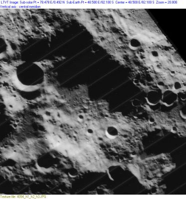
LPOD Photo Gallery Lunar Orbiter Images
- Although it is not mentioned in the LPI's search-list of orbital Apollo photographs, the crater called Scott WAS photographed during the mission of Apollo 15. It was captured near the central part of the upper margin of frame AS15-95-12988.
- Research: Danny Caes.
Maps
([/LAC%20zone LAC zone] 144A1) USGS Digital Atlas PDF
Description
Description: Wikipedia
Additional Information
Depth data from [/Kurt%20Fisher%20crater%20depths Kurt Fisher database]
- Westfall, 2000: 5.57 km
- Cherrington, 1969: 2.98 km.
The shadows in LO-IV-094H (as measured by [/LTVT LTVT]) indicate height differences of up to 6,860 m from the ridge on the northern wall to the crater floor. But there is a considerable element of luck in finding shadows that span the most appropriate points. For example, in this case, the highest point along the NE ridge is near the apex of the inverted-V in LO-IV-094H, and the azimuth of the sun was such that this point did not cast a shadow onto the crater floor.
By contrast in LO-IV-106H,  the shadow did fall on the crater floor, and LTVT found a drop of 8,660 m. Click on the image at left for further details. This shadow measurement may be compared to the result expected on the basis of elevations listed in the Unified Lunar Control Network-2005, which suggests that height differences of up to 9,300 m might be expected.
The height difference of 8,660 m is already quite respectable, as is 6,860 m. The tallest mountains on Earth reach little more than 5,000 m above the surrounding terrain (see the "Comparisons" section of the Wikipedia article regarding Mount Everest). So the ascent from the floor of Scott to this high point on the north rim would be quite arduous.
- JimMosher JimMosher
Nomenclature
- Named for Captain Robert Falcon Scott, CVO, RN, (6 June 1868 – 29 March 1912), a Royal Naval officer and Antarctic explorer. In the so-called "Race to the South Pole" Scott came second, behind the Norwegian Roald [/Amundsen Amundsen]. Scott and his four companions died while trying to return to their base.
- Name originally proposed by Arthur and used by [/Wilkins%20and%20Moore Wilkins and Moore] in their The Moon, but it did not become official nomenclature until used in the [/Rectified%20Lunar%20Atlas Rectified Lunar Atlas] (1963) and approved by the IAU in 1964 ([/Whitaker Whitaker], 1999, p. 234).
LPOD Articles
Bibliography
- Hill, Harold. [/A%20Portfolio%20of%20Lunar%20Drawings A Portfolio of Lunar Drawings], pages 190, 191.
- MacRobert, Alan M. Exploring the Moon's South Pole. Sky and Telescope, October 1993. pages 66-67.
J. L. Scott and double star observations
Not at all related to Captain Robert Falcon Scott, but... could somebody tell me more about a certain J.L.Scott who seems to have been a double star observer? J.L.Scott is briefly mentioned in the SKY CATALOGUE 2000.0, Volume 2 (page X; Table I, Double Star Designation Codes). - DannyCaes DannyCaes Jul 31, 2015
This page has been edited 1 times. The last modification was made by - tychocrater tychocrater on Jun 13, 2009 3:24 pm - afx3u2