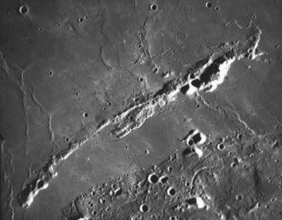
Montes Agricola
Contents
Montes Agricola (with Rima Chopin)
|
Lat: 29.08°N, Long: 54.23°W, Diam: 161.19 km, Height: km, [/R%C3%BCkl%2018 Rükl: 18] |
Table of Contents
[#Montes Agricola (with Rima Chopin) Montes Agricola (with Rima Chopin)]
[#Montes Agricola (with Rima Chopin)-Images Images]
[#Montes Agricola (with Rima Chopin)-Maps Maps]
[#Montes Agricola (with Rima Chopin)-Description Description]
[#Montes Agricola (with Rima Chopin)-Description-Wikipedia Wikipedia]
[#Montes Agricola (with Rima Chopin)-Additional Information Additional Information]
[#Montes Agricola (with Rima Chopin)-Nomenclature Nomenclature]
[#Montes Agricola (with Rima Chopin)-LPOD Articles LPOD Articles]
[#Montes Agricola (with Rima Chopin)-EPOD Articles EPOD Articles]
[#Montes Agricola (with Rima Chopin)-Bibliography Bibliography]

Apollo 15 image AS15-M-2484 HR Montes Agricola is the mountain chain running diagonally across the photo. Other IAU-named features in the field include [/Mons%20Herodotus Mons Herodotus] (the isolated peak at bottom center), [/Dorsum%20Niggli Dorsum Niggli] running south from the part of Montes Agricola directly above Mons Herodotus, [/Dorsa%20Burnet Dorsa Burnet] running north from the south tip of Montes Agricola, [/Dorsa%20Whiston Dorsa Whiston] running north a little to the right of that, [/Rima%20Agricola Rima Agricola] (a major sinuous rille snaking along the south side of Montes Agricola), the broader but less long [/Rima%20Cleopatra Rima Cleopatra] on the north side, the crater [/Humason Humason] in the upper left, and the horseshoe-shaped [/Aloha Aloha] (near Rima Cleopatra).
Images
LPOD Photo Gallery images Lunar Orbiter Images Apollo Images Lunar Image of the Week 04/21/2009
- Lunar Orbiter 5's Frame 209 shows Montes Agricola near the photograph's right margin. North is to the right. Research Danny Caes.
- AS15-88-11982 shows Montes Agricola and the northern part of the Aristarchus plateau. This photograph was printed on pages 253-254 of the article To The Mountains Of The Moon by Kenneth F. Weaver; National Geographic, february 1972 (Apollo 15). Research Danny Caes.
- AS15-88-11984 is another one of Apollo 15's orbital Hasselblads of Montes Agricola. Research: David Woods (Apollo 15 Flight Journal).
- The southern part of Montes Agricola is seen at the top margin of AS15-M-2614, which is one of Apollo 15's oblique southward looking Fairchild-camera photographs of the [/Aristarchus%20plateau Aristarchus plateau] and environs. Research Danny Caes.
Maps
([/LAC%20zone LAC zone] 38B2) LAC map Geologic map LM map LTO map
Description
Wikipedia
Additional Information
- IAU page: Montes Agricola
Nomenclature
- Named for Georgius Agricola (March 24, 1494 – November 21, 1555), a German scholar and Earth scientist known as "the father of mineralogy". His real name was Georg Bauer; Agricola is the Latinised version of his name, Bauer meaning peasant. He is best known for his book De Re Metallica. It is a complete and systematic treatise on mining and metallurgy, illustrated with many fine and interesting woodcuts which illustrate every conceivable process to extract ores from the ground and metal from the ore. De re metallica is considered a classic document of Medieval metallurgy, unsurpassed for two centuries. In 1912, the Mining Magazine (London) published an English translation.
- The mare-like region between Montes Agricola and the [/Aristarchus%20Plateau Aristarchus Plateau] is unofficially called the Agricola Straits, see Lunar Image of the Week 04/21/2009.
- According to chart 24 in the Times Atlas of the Moon, the southwestern end of Montes Agricola is (or was?) officially known as Herodotus Eta. - DannyCaes DannyCaes Feb 16, 2014
- The subdivisions of Montes Agricola were called Herodotus Eta (southwestern end), Herodotus Delta, Kappa, and Iota (the northeastern end) on chart SLC F3 (System of Lunar Craters, 1966).
- The rille which runs along the southern edge of Montes Agricola was once called Rima Chopin, see Lunar Topographic Orthophotomap 38-B2.
- There is also a craterlet called Agricola at the Taurus Littrow Valley (the landing site of Apollo 17). Agricola (crater) - "This was the Latin name of Georg Bauer (1494-1555), who wrote some of the first known treatises on mineralogy, geology, and mining. His most famous work was on 16th Century mining and metallurgy. This book, De Re Metallica, was translated from Latin into English by Herbert Hoover and his wife. Hoover (the 31st President of the United States) is also honored by this crater designation for his lifelong intellectual exploration of history and government and for his humanistic concern for all people following World War I and the Great Depression." ALSJ-contributor Harald Kucharek notes "'Bauer' is German for 'Farmer' and 'Agricola' has the same meaning in Latin. During Bauer's era, scholars not only published in Latin, but also changed their names to the Latin equivalents." (source: APOLLO LUNAR SURFACE JOURNAL, Eric M. Jones).
LPOD Articles
EPOD Articles
Bibliography
- [/NASA%20SP-362 Apollo Over the Moon], Chapter 4: The Maria (Part 2), Figure 72 (the western part of Montes Agricola and [/Dorsa%20Burnet Dorsa Burnet])
[/Alphabetical%20Index Named Features] -- Prev: [/Mons%20Agnes Mons Agnes] -- Next: [/Rima%20Agricola Rima Agricola]
This page has been edited 1 times. The last modification was made by - tychocrater tychocrater on Jun 13, 2009 3:24 pm - afx3u3