Lindsay
Contents
Lindsay - and Barcroft (Dollond B) southeast of it
(Lindsay was previously Dollond C)
| Lat: 7.0°S, Long: 13.0°E, Diam: 32 km, Depth: 0.62 km, Rükl: 45 |
Table of Contents
[#Lindsay - and Barcroft (Dollond B) southeast of it Lindsay - and Barcroft (Dollond B) southeast of it]
[#Lindsay - and Barcroft (Dollond B) southeast of it-Images Images]
[#Lindsay - and Barcroft (Dollond B) southeast of it-Maps Maps]
[#Lindsay - and Barcroft (Dollond B) southeast of it-Description Description]
[#Lindsay - and Barcroft (Dollond B) southeast of it-Description: Wikipedia Description: Wikipedia]
[#Lindsay - and Barcroft (Dollond B) southeast of it-Additional Information Additional Information]
[#Lindsay - and Barcroft (Dollond B) southeast of it-Ruins of a very ancient large crater west of Lindsay Ruins of a very ancient large crater west of Lindsay]
[#Lindsay - and Barcroft (Dollond B) southeast of it-Nomenclature Nomenclature]
[#Lindsay - and Barcroft (Dollond B) southeast of it-LPOD Articles LPOD Articles]
[#Lindsay - and Barcroft (Dollond B) southeast of it-Bibliography Bibliography]

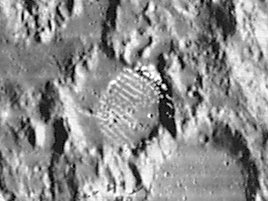
Lunar Orbiter IV 089 H3
Lindsay (Dollond C) at center of the image (with several odd white blemishes from the photographic unit aboard Lunar Orbiter IV) and larger Barcroft (Dollond B) southeast of it. Barcroft was one of the discontinued names from H.P.Wilkins and P.Moore (see their book The Moon).
Images
LPOD Photo Gallery Lunar Orbiter Images Apollo Images (all orbital Apollo photographs of Lindsay are online as Dollond C).
- Several "forgotten" orbital photographs of Lindsay (Dollond C) are online in Apollo 16's REV 37 (oblique northward looking Fairchild camera frames). One of those photographs, AS16-M-1397, shows Lindsay slightly above and to the left of the frame's centre. An almost identical looking frame is AS16-M-0833, from REV 27.
- Research orbital Apollo 16 photography: Danny Caes
Maps
(LAC zone 78A4) LAC map Geologic map LM map AIC map LTO map
Description
Description: Wikipedia
Additional Information
Depth data from Kurt Fisher database
- Westfall, 2000: 0.62 km
- Viscardy, 1985: 1.55 km
Ruins of a very ancient large crater west of Lindsay
- West of Lindsay there seems to be a circle-shaped arrangement of elevations that looks more-or-less like the ruins of a large crater the size of Hipparchus. This circle-shaped tendency is depicted on SLC map C5 (System of Lunar Craters, 1966). How much of this ancient crater could be observed during low-sun circumstances? - DannyCaes DannyCaes Jan 21, 2017
Nomenclature
- Eric Mervyn Lindsay (January 26, 1907–July 27, 1974) was an Irish astronomer. He is more noted for his political influence in favor of astronomy than for important astronomical discoveries. For example, he was responsible for persuading the Irish government and Harvard University to found a telescope at Boyden Station in South Africa for the purpose of charting the southern skies. Dr. Lindsay was also instrumental in the founding of Armagh Planetarium.
- Related material on other features named after Irish scientists.
- The LPI's red labeled scan of frame LOIV-089-h3 shows the name Lindsay as Lindsey.- DannyCaes DannyCaes Jul 1, 2012
LPOD Articles
Bibliography
Other moon-related Lindsays:
- John F. Lindsay; Lunar Stratigraphy and Sedimentology (Elsevier).
This page has been edited 1 times. The last modification was made by - tychocrater tychocrater on Jun 13, 2009 3:24 pm - afx3u2