Difference between revisions of "Flamsteed"
| (2 intermediate revisions by the same user not shown) | |||
| Line 3: | Line 3: | ||
{| class="wiki_table" | {| class="wiki_table" | ||
| | | | ||
| − | Lat: 4.51°S, Long: 44.34°W, Diam: 19.34 km, Depth: 2.16 km, [ | + | Lat: 4.51°S, Long: 44.34°W, Diam: 19.34 km, Depth: 2.16 km, [[R%C3%BCkl%2040|Rükl: 40]], [[Stratigraphy|Eratosthenian]]<br /> |
|} | |} | ||
<div id="toc"> | <div id="toc"> | ||
| − | + | [http://www.lpod.org/coppermine/displayimage.php?pid=283&fullsize=1 [[Image:Flamsteed%20&%20Flam%20P%20iv_143_h3%20.jpg|external image Flamsteed%20&%20Flam%20P%20iv_143_h3%20.jpg]]]<br /> ''[http://lpod.org/coppermine/displayimage.php?pos=-283 Lunar Orbiter IV-143-h3]''<br /> This overhead view is centered on the ruined 112-km diameter ring of '''Flamsteed P'''.<br /> '''Flamsteed''' itself is the pronounced crater just inside the southern end of this ring. To its southeast is 10-km '''Flamsteed B''', and on the floor of the ruined ring are 6-km '''Flamsteed D''' and 4-km '''Flamsteed K'''.<br /> The individual arc-shaped sections of the large '''Flamsteed P''' ring were once known as '''Flamsteed Gamma''' (west of '''Flamsteed'''), '''Flamsteed Delta''' (northwest of '''Flamsteed'''), '''Flamsteed Psi''' (north-northwest of '''Flamsteed'''), '''Flamsteed Phi''' (north-northeast of '''Flamsteed'''), '''Flamsteed Beta''' (northeast of '''Flamsteed'''), and '''Flamsteed Lambda''' (east of '''Flamsteed'''), see chart [http://the-moon.us/wiki/SLC-F5 SLC F5] (''system of Lunar Craters'', 1966).<br /> <br /> | |
| − | |||
==Images== | ==Images== | ||
[http://www.lpod.org/coppermine/thumbnails.php?album=search&type=full&search=Flamsteed LPOD Photo Gallery] [http://www.lpi.usra.edu/resources/lunar_orbiter/bin/srch_nam.shtml?Flamsteed%7C0 Lunar Orbiter Images] [http://www.lpi.usra.edu/resources/apollo/search/feature/?feature=Flamsteed Apollo Images]<br /> | [http://www.lpod.org/coppermine/thumbnails.php?album=search&type=full&search=Flamsteed LPOD Photo Gallery] [http://www.lpi.usra.edu/resources/lunar_orbiter/bin/srch_nam.shtml?Flamsteed%7C0 Lunar Orbiter Images] [http://www.lpi.usra.edu/resources/apollo/search/feature/?feature=Flamsteed Apollo Images]<br /> | ||
| Line 18: | Line 17: | ||
At the northern part of the '''Flamsteed P''' ring (2°20' South/ 43°55' West), an unnamed rough looking craterlet with surrounding field of boulders was captured on Lunar Orbiter 3 frame [http://www.lpi.usra.edu/resources/lunarorbiter/images/preview/3189_h2.jpg LO3-189-h2].<br /> A section of this photograph (close-up of the rough looking craterlet) was printed in the book ''Geology on the Moon'' (J.E.Guest/ R.Greeley). In the German edition of this book (''Geology auf dem Mond''), this photograph was printed on page 136.<br /> The high-albedo ejectablanket around this craterlet, appearing as a bright dot or "point", is seen on page 150 (LAC 75) in the ''Clementine Atlas of the Moon'' (Bussey/ Spudis) at the above mentioned coordinates. In other words: it is observable through common telescopes; before, during, and after Full Moon.<br /> It is also detectable on chart 26 (page 65) in the ''21st Century Atlas of the Moon'' (Wood/ Collins), at location H-1/2 (the northern part of '''Flamsteed P''''s floor).<br /> See also the purple "blob" in the USGS's ''Geologic map of the Flamsteed K region'' ([http://www.lpi.usra.edu/resources/mapcatalog/usgs/I626/ I-626]).<br /> Research: Danny Caes<br /> <br /> | At the northern part of the '''Flamsteed P''' ring (2°20' South/ 43°55' West), an unnamed rough looking craterlet with surrounding field of boulders was captured on Lunar Orbiter 3 frame [http://www.lpi.usra.edu/resources/lunarorbiter/images/preview/3189_h2.jpg LO3-189-h2].<br /> A section of this photograph (close-up of the rough looking craterlet) was printed in the book ''Geology on the Moon'' (J.E.Guest/ R.Greeley). In the German edition of this book (''Geology auf dem Mond''), this photograph was printed on page 136.<br /> The high-albedo ejectablanket around this craterlet, appearing as a bright dot or "point", is seen on page 150 (LAC 75) in the ''Clementine Atlas of the Moon'' (Bussey/ Spudis) at the above mentioned coordinates. In other words: it is observable through common telescopes; before, during, and after Full Moon.<br /> It is also detectable on chart 26 (page 65) in the ''21st Century Atlas of the Moon'' (Wood/ Collins), at location H-1/2 (the northern part of '''Flamsteed P''''s floor).<br /> See also the purple "blob" in the USGS's ''Geologic map of the Flamsteed K region'' ([http://www.lpi.usra.edu/resources/mapcatalog/usgs/I626/ I-626]).<br /> Research: Danny Caes<br /> <br /> | ||
==Maps== | ==Maps== | ||
| − | ''([ | + | ''([[LAC%20zone|LAC zone]] 75A3)'' [http://www.lpi.usra.edu/resources/mapcatalog/LAC/lac75/ LAC map] [http://www.lpi.usra.edu/resources/mapcatalog/usgs/I385/ Geologic map] [http://www.lpi.usra.edu/resources/mapcatalog/AIC/AIC75A/ AIC map]<br /> <br /> |
==Description== | ==Description== | ||
| − | '''Flamsteed''' is a small complex crater with rim slumps, especially on the southern edge where a scallop marks where wall material slid into the crater. A large ruined crater, '''Flamsteed P''', extends to the north of '''Flamsteed'''. This 112 km diameter partial ring was a normal crater that has been nearly completely covered by [ | + | '''Flamsteed''' is a small complex crater with rim slumps, especially on the southern edge where a scallop marks where wall material slid into the crater. A large ruined crater, '''Flamsteed P''', extends to the north of '''Flamsteed'''. This 112 km diameter partial ring was a normal crater that has been nearly completely covered by [[Oceanus%20Procellarum|Oceanus Procellarum]] lava flows. <span class="membersnap">- tychocrater <small>Sep 29, 2007</small></span><br /> <br /> |
===Elger=== | ===Elger=== | ||
| − | ''([ | + | ''([[IAU%20directions|IAU Directions]])'' FLAMSTEED.--A bright ring-plain, 9 miles in diameter, in a barren region in the [[Oceanus%20Procellarum|Oceanus Procellarum]], N.W. of [[Wichmann|Wichmann]]. It has a regular border (broken at one place on the N. by a gap, which probably represents a crater), rising to a height of about 1,400 feet above the surrounding plain. A great enclosure, 60 miles in diameter, lies on the N. of Flamsteed. It is defined by low ridges which exhibit many breaks, though under a high light the ring is apparently continuous. Within are several small craters and two considerable hills, nearly central.<br /> <br /> |
===Wikipedia=== | ===Wikipedia=== | ||
[http://en.wikipedia.org/wiki/Flamsteed_(crater) Flamsteed]<br /> <br /> | [http://en.wikipedia.org/wiki/Flamsteed_(crater) Flamsteed]<br /> <br /> | ||
| Line 28: | Line 27: | ||
* IAU page: [http://planetarynames.wr.usgs.gov/Feature/1974 Flamsteed] | * IAU page: [http://planetarynames.wr.usgs.gov/Feature/1974 Flamsteed] | ||
| − | * Depth data from [ | + | * Depth data from [[Kurt%20Fisher%20Crater%20Depths|Kurt Fisher database]] |
** Pike, 1976: 2.16 km | ** Pike, 1976: 2.16 km | ||
** Arthur, 1974: 2.16 km | ** Arthur, 1974: 2.16 km | ||
| Line 35: | Line 34: | ||
* [http://www2.lpod.org/wiki/July_9,_2004 Surveyor I] landed north of '''Flamsteed''' within the ruined crater '''Flamsteed P'''. | * [http://www2.lpod.org/wiki/July_9,_2004 Surveyor I] landed north of '''Flamsteed''' within the ruined crater '''Flamsteed P'''. | ||
* [http://www.lpi.usra.edu/resources/mapcatalog/usgs/I626/ USGS's Geologic Map of the Flamsteed K region (I-626)] shows the landing site of ''Surveyor 1'' within the '''Flamsteed P''' ring, north-northeast of the bowl-shaped crater '''Flamsteed K'''. | * [http://www.lpi.usra.edu/resources/mapcatalog/usgs/I626/ USGS's Geologic Map of the Flamsteed K region (I-626)] shows the landing site of ''Surveyor 1'' within the '''Flamsteed P''' ring, north-northeast of the bowl-shaped crater '''Flamsteed K'''. | ||
| − | * Satellite craters '''Flamsteed C, F, FA''' and '''FB''' are on the [ | + | * Satellite craters '''Flamsteed C, F, FA''' and '''FB''' are on the [[ALPO%20list%20of%20bright%20ray%20craters|ALPO list of bright ray craters]]. |
| − | * '''Flamsteed''' and '''Flamsteed B & GC''' are thermal anomaly craters, implying youthful ages - [ | + | * '''Flamsteed''' and '''Flamsteed B & GC''' are thermal anomaly craters, implying youthful ages - [[Moore%20et%20al%2C%201980|Moore et al, 1980]] |
* '''Flamsteed P''' - also called the '''''Flamsteed Ring''''' - [http://altairvi.blogspot.com/2007/11/extended-lunar-module-mission-1967.html in 1967] was the proposed site of a future extended lunar mission. | * '''Flamsteed P''' - also called the '''''Flamsteed Ring''''' - [http://altairvi.blogspot.com/2007/11/extended-lunar-module-mission-1967.html in 1967] was the proposed site of a future extended lunar mission. | ||
* '''Flamsteed F''' has an oblong depression outside the south-southwestern part of its rim, see''':''' http://bit.ly/2hv4w93 | * '''Flamsteed F''' has an oblong depression outside the south-southwestern part of its rim, see''':''' http://bit.ly/2hv4w93 | ||
<br /> | <br /> | ||
==Quite large circle-shaped formation southwest of the Flamsteed P ring== | ==Quite large circle-shaped formation southwest of the Flamsteed P ring== | ||
| − | What seems to be a circle-shaped formation southwest of the '''Flamsteed P ring''' is an arrangement of wrinkle ridges, more-or-less'''...''' well'''...''' ''circle shaped'' (see [http://the-moon.us/wiki/SLC-F5 SLC-map F5]). Is it perhaps part of the remains of the '''Flamsteed-Billy impact basin'''? <span class="membersnap">- | + | What seems to be a circle-shaped formation southwest of the '''Flamsteed P ring''' is an arrangement of wrinkle ridges, more-or-less'''...''' well'''...''' ''circle shaped'' (see [http://the-moon.us/wiki/SLC-F5 SLC-map F5]). Is it perhaps part of the remains of the '''Flamsteed-Billy impact basin'''? <span class="membersnap">- DannyCaes <small>Feb 4, 2017</small></span><br /> <br /> |
==Nomenclature== | ==Nomenclature== | ||
* Named for [http://en.wikipedia.org/wiki/John_Flamsteed John Flamsteed] (19 August 1646 - 31 December 1719), an English astronomer. On 4 March 1675 he was appointed by royal warrant "The King's Astronomical Observator" — the first British Astronomer Royal, with an allowance of £100 a year. | * Named for [http://en.wikipedia.org/wiki/John_Flamsteed John Flamsteed] (19 August 1646 - 31 December 1719), an English astronomer. On 4 March 1675 he was appointed by royal warrant "The King's Astronomical Observator" — the first British Astronomer Royal, with an allowance of £100 a year. | ||
| − | * According to ''[ | + | * According to ''[[Whitaker|Whitaker]]'' (p. 219), this name was introduced by [[M%C3%A4dler|Mädler]]. The names '''Flamstedius''' and '''Flamsteedius''' had been used earlier by [http://en.wikipedia.org/wiki/John_Keill John Keill] and by [http://en.wikipedia.org/wiki/Maximilian_Hell Maximilian Hell], but for different formations (pp. 89, 93-94). |
| − | * Printed as '''Flamste<u>a</u>d''' on top of the nomenclature gazetteer near the right margin of the National Geographic Society's revised and reprinted edition of the map THE EARTH'S MOON. <span class="membersnap">- | + | * Printed as '''Flamste<u>a</u>d''' on top of the nomenclature gazetteer near the right margin of the National Geographic Society's revised and reprinted edition of the map THE EARTH'S MOON. <span class="membersnap">- DannyCaes <small>Oct 7, 2015</small></span> (this map is a nitpicker's delight!). |
| − | * Crater '''Flamsteed K''' (on the floor of the '''Flamsteed P''' ring) is called '''Flamsteed D''' on chart 51 in the ''Times Atlas of the Moon''. <span class="membersnap">- | + | * Crater '''Flamsteed K''' (on the floor of the '''Flamsteed P''' ring) is called '''Flamsteed D''' on chart 51 in the ''Times Atlas of the Moon''. <span class="membersnap">- DannyCaes <small>Mar 17, 2014</small></span> |
| − | * Crater '''Flamsteed D''' (also on the floor of the '''Flamsteed P''' ring) is called '''Flamsteed E''' on chart 51 in the ''Times Atlas''. <span class="membersnap">- | + | * Crater '''Flamsteed D''' (also on the floor of the '''Flamsteed P''' ring) is called '''Flamsteed E''' on chart 51 in the ''Times Atlas''. <span class="membersnap">- DannyCaes <small>Mar 18, 2014</small></span> |
| − | * In selenography, craters '''Flamsteed D''' and '''K''' (both in the '''Flamsteed P''' ring) seem to be quite a confusing pair, because on LAC 75 (page 151) in the 2012 edition of the ''Clementine Atlas of the Moon'' (Bussey/ Spudis), '''Flamsteed D''' was printed at the location of '''Flamsteed K''', and '''Flamsteed K''' at the location of '''Flamsteed D'''.<span class="membersnap">- | + | * In selenography, craters '''Flamsteed D''' and '''K''' (both in the '''Flamsteed P''' ring) seem to be quite a confusing pair, because on LAC 75 (page 151) in the 2012 edition of the ''Clementine Atlas of the Moon'' (Bussey/ Spudis), '''Flamsteed D''' was printed at the location of '''Flamsteed K''', and '''Flamsteed K''' at the location of '''Flamsteed D'''.<span class="membersnap">- DannyCaes <small>Mar 18, 2014</small></span> |
| − | * In the 2004 edition of the ''Clementine Atlas'', '''Flamsteed D''' was "'''Flamsteed E'''", and '''Flamsteed K''' was "'''Flamsteed D'''".<span class="membersnap">- | + | * In the 2004 edition of the ''Clementine Atlas'', '''Flamsteed D''' was "'''Flamsteed E'''", and '''Flamsteed K''' was "'''Flamsteed D'''".<span class="membersnap">- DannyCaes <small>Mar 19, 2014</small></span> |
* '''Flamsteed P''' is called the '''''Flamsteed Ring''''' on Chart 26 (page 65) of the ''21st Century Atlas of the Moon'' (Charles A. Wood/ Maurice J.S. Collins). | * '''Flamsteed P''' is called the '''''Flamsteed Ring''''' on Chart 26 (page 65) of the ''21st Century Atlas of the Moon'' (Charles A. Wood/ Maurice J.S. Collins). | ||
<br /> | <br /> | ||
| Line 76: | Line 75: | ||
---- | ---- | ||
| − | [ | + | [[Alphabetical%20Index|Named Features]] -- Prev: [[Rima%20Flammarion|Rima Flammarion]] -- Next: [[Flank|Flank]]<br /> |
---- | ---- | ||
| − | + | </div> | |
Latest revision as of 02:49, 16 April 2018
Contents
- 1 Flamsteed - and the Flamsteed P ring north of it
- 1.1 Images
- 1.2 Rough looking craterlet with surrounding field of boulders
- 1.3 Maps
- 1.4 Description
- 1.5 Additional Information
- 1.6 Quite large circle-shaped formation southwest of the Flamsteed P ring
- 1.7 Nomenclature
- 1.8 LROC Articles
- 1.9 LPOD Articles
- 1.10 APOD Articles
- 1.11 Bibliography
- 1.12 John Flamsteed in the Sourcebook Project (William R. Corliss)
Flamsteed - and the Flamsteed P ring north of it
|
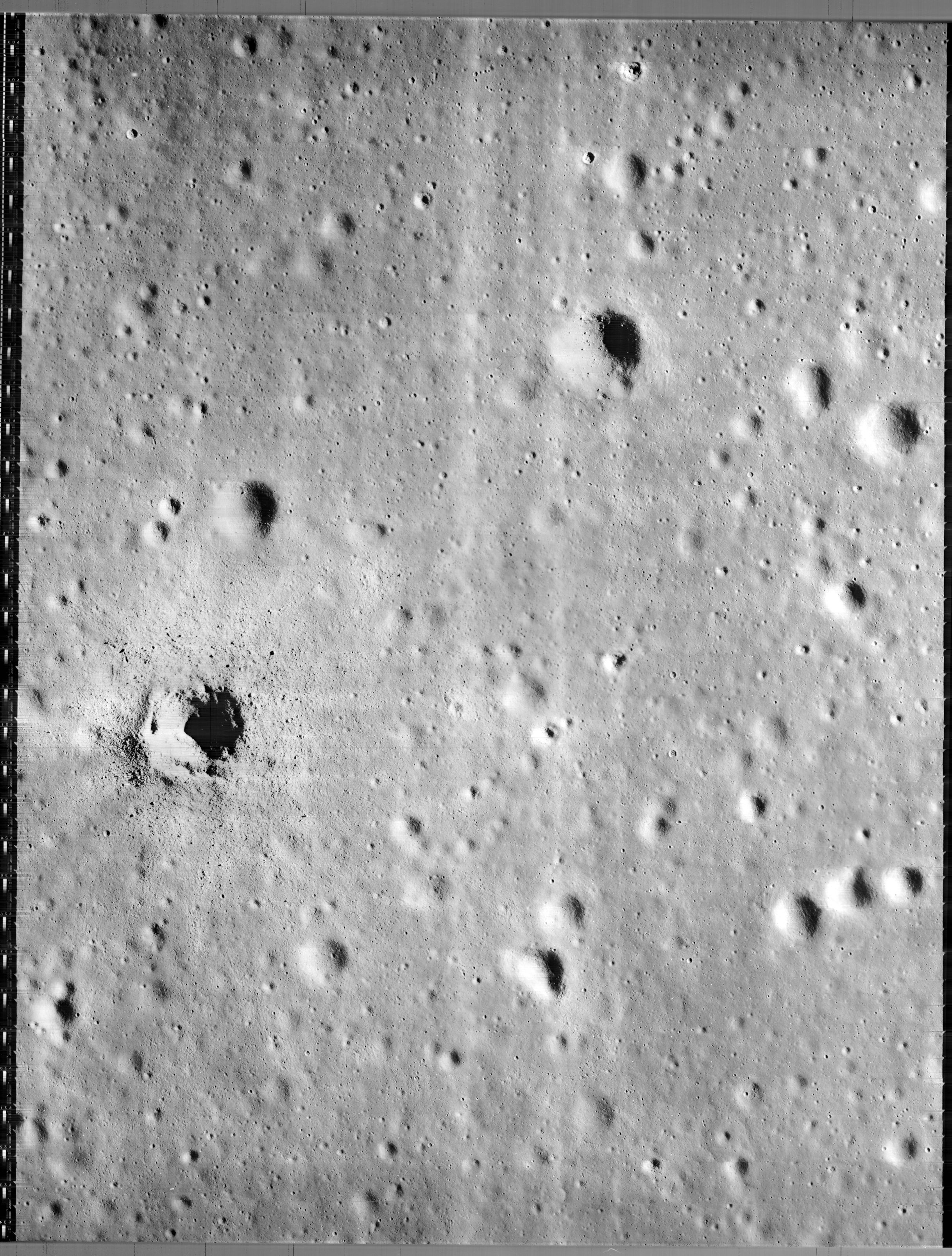
Lat: 4.51°S, Long: 44.34°W, Diam: 19.34 km, Depth: 2.16 km, Rükl: 40, Eratosthenian |

Lunar Orbiter IV-143-h3
This overhead view is centered on the ruined 112-km diameter ring of Flamsteed P.
Flamsteed itself is the pronounced crater just inside the southern end of this ring. To its southeast is 10-km Flamsteed B, and on the floor of the ruined ring are 6-km Flamsteed D and 4-km Flamsteed K.
The individual arc-shaped sections of the large Flamsteed P ring were once known as Flamsteed Gamma (west of Flamsteed), Flamsteed Delta (northwest of Flamsteed), Flamsteed Psi (north-northwest of Flamsteed), Flamsteed Phi (north-northeast of Flamsteed), Flamsteed Beta (northeast of Flamsteed), and Flamsteed Lambda (east of Flamsteed), see chart SLC F5 (system of Lunar Craters, 1966).
Images
LPOD Photo Gallery Lunar Orbiter Images Apollo Images
- Lunar Orbiter 1's frames 1185 to 1199, and 1207 to 1215 show the northeastern parts of the Flamsteed P ring.
- Lunar Orbiter 3's frame 172 shows a west-southwestern oblique look at the Flamsteed P ring.
- Lunar Orbiter 3's frames 3181 to 3184 show the northeastern parts of the Flamsteed P ring. Frames 3195 to 3200 show the eastern parts of it. Frames 3202 to 3204 show the eastern and east-southeastern parts of it. Frames 3205 to 3212 show the north-northwestern and north-northeastern parts of it.
- Research Lunar Orbiter frames: Danny Caes
Rough looking craterlet with surrounding field of boulders
At the northern part of the Flamsteed P ring (2°20' South/ 43°55' West), an unnamed rough looking craterlet with surrounding field of boulders was captured on Lunar Orbiter 3 frame LO3-189-h2.
  A section of this photograph (close-up of the rough looking craterlet) was printed in the book Geology on the Moon (J.E.Guest/ R.Greeley). In the German edition of this book (Geology auf dem Mond), this photograph was printed on page 136.
  The high-albedo ejectablanket around this craterlet, appearing as a bright dot or "point", is seen on page 150 (LAC 75) in the Clementine Atlas of the Moon (Bussey/ Spudis) at the above mentioned coordinates. In other words: it is observable through common telescopes; before, during, and after Full Moon.
  It is also detectable on chart 26 (page 65) in the 21st Century Atlas of the Moon (Wood/ Collins), at location H-1/2 (the northern part of Flamsteed P's floor).
  See also the purple "blob" in the USGS's Geologic map of the Flamsteed K region (I-626).
  Research: Danny Caes
Maps
(LAC zone 75A3) LAC map Geologic map AIC map
Description
Flamsteed is a small complex crater with rim slumps, especially on the southern edge where a scallop marks where wall material slid into the crater. A large ruined crater, Flamsteed P, extends to the north of Flamsteed. This 112 km diameter partial ring was a normal crater that has been nearly completely covered by Oceanus Procellarum lava flows. - tychocrater Sep 29, 2007
Elger
(IAU Directions) FLAMSTEED.--A bright ring-plain, 9 miles in diameter, in a barren region in the Oceanus Procellarum, N.W. of Wichmann. It has a regular border (broken at one place on the N. by a gap, which probably represents a crater), rising to a height of about 1,400 feet above the surrounding plain. A great enclosure, 60 miles in diameter, lies on the N. of Flamsteed. It is defined by low ridges which exhibit many breaks, though under a high light the ring is apparently continuous. Within are several small craters and two considerable hills, nearly central.
Wikipedia
Additional Information
- IAU page: Flamsteed
- Depth data from Kurt Fisher database
- Pike, 1976: 2.16 km
- Arthur, 1974: 2.16 km
- Westfall, 2000: 2.16 km
- Viscardy, 1985: 2.16 km
- Surveyor I landed north of Flamsteed within the ruined crater Flamsteed P.
- USGS's Geologic Map of the Flamsteed K region (I-626) shows the landing site of Surveyor 1 within the Flamsteed P ring, north-northeast of the bowl-shaped crater Flamsteed K.
- Satellite craters Flamsteed C, F, FA and FB are on the ALPO list of bright ray craters.
- Flamsteed and Flamsteed B & GC are thermal anomaly craters, implying youthful ages - Moore et al, 1980
- Flamsteed P - also called the Flamsteed Ring - in 1967 was the proposed site of a future extended lunar mission.
- Flamsteed F has an oblong depression outside the south-southwestern part of its rim, see: http://bit.ly/2hv4w93
Quite large circle-shaped formation southwest of the Flamsteed P ring
What seems to be a circle-shaped formation southwest of the Flamsteed P ring is an arrangement of wrinkle ridges, more-or-less... well... circle shaped (see SLC-map F5). Is it perhaps part of the remains of the Flamsteed-Billy impact basin? - DannyCaes Feb 4, 2017
Nomenclature
- Named for John Flamsteed (19 August 1646 - 31 December 1719), an English astronomer. On 4 March 1675 he was appointed by royal warrant "The King's Astronomical Observator" — the first British Astronomer Royal, with an allowance of £100 a year.
- According to Whitaker (p. 219), this name was introduced by Mädler. The names Flamstedius and Flamsteedius had been used earlier by John Keill and by Maximilian Hell, but for different formations (pp. 89, 93-94).
- Printed as Flamstead on top of the nomenclature gazetteer near the right margin of the National Geographic Society's revised and reprinted edition of the map THE EARTH'S MOON. - DannyCaes Oct 7, 2015 (this map is a nitpicker's delight!).
- Crater Flamsteed K (on the floor of the Flamsteed P ring) is called Flamsteed D on chart 51 in the Times Atlas of the Moon. - DannyCaes Mar 17, 2014
- Crater Flamsteed D (also on the floor of the Flamsteed P ring) is called Flamsteed E on chart 51 in the Times Atlas. - DannyCaes Mar 18, 2014
- In selenography, craters Flamsteed D and K (both in the Flamsteed P ring) seem to be quite a confusing pair, because on LAC 75 (page 151) in the 2012 edition of the Clementine Atlas of the Moon (Bussey/ Spudis), Flamsteed D was printed at the location of Flamsteed K, and Flamsteed K at the location of Flamsteed D.- DannyCaes Mar 18, 2014
- In the 2004 edition of the Clementine Atlas, Flamsteed D was "Flamsteed E", and Flamsteed K was "Flamsteed D".- DannyCaes Mar 19, 2014
- Flamsteed P is called the Flamsteed Ring on Chart 26 (page 65) of the 21st Century Atlas of the Moon (Charles A. Wood/ Maurice J.S. Collins).
LROC Articles
LPOD Articles
- The Basis for a New Atlas (LRO's close-up of Flamsteed with part of the Flamsteed P ring).
APOD Articles
- The Shadow of Surveyor 1 (June the 2nd of 2016: the 50th anniversary of the soft landing of Surveyor 1 at the Flamsteed P ring).
Bibliography
-Surveyor 1 in the Flamsteed P ring:
- Surveyor: Candid Camera On The Moon by Homer E. Newell (National Geographic October 1966, pages 578 to 592).
John Flamsteed in the Sourcebook Project (William R. Corliss)
- In Mysterious Universe, a handbook of astronomical anomalies (1979) :
- Page 572: The Temporary Stars (David E. Packer, Journal of the British Astronomical Association, 1894).
Named Features -- Prev: Rima Flammarion -- Next: Flank