Dorsa Ewing
Contents
Dorsa Ewing
|
Lat: 10.2°S, Long: 39.4°W, Length: 141 km, Height: km, [/R%C3%BCkl%2041 Rükl: 41] |
Table of Contents
[#Dorsa Ewing Dorsa Ewing]
[#Dorsa Ewing-Images Images]
[#Dorsa Ewing-Maps Maps]
[#Dorsa Ewing-Description Description]
[#Dorsa Ewing-Description: Wikipedia Description: Wikipedia]
[#Dorsa Ewing-Additional Information Additional Information]
[#Dorsa Ewing-Nomenclature Nomenclature]
[#Dorsa Ewing-LPOD Articles LPOD Articles]
[#Dorsa Ewing-Bibliography Bibliography]

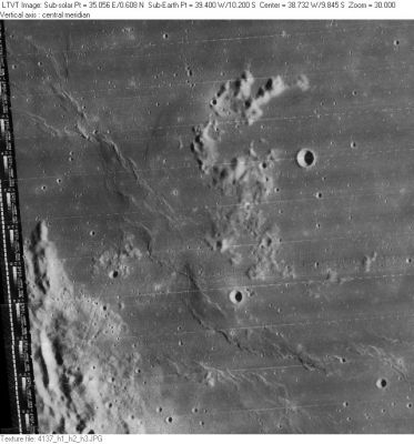
LO-IV-137H The Dorsa Ewing defined by the position and diameter given above (taken from the on-line [/IAU%20Planetary%20Gazetteer IAU Planetary Gazetteer]) extends from the upper left to the lower right of this [/Lunar%20Orbiter Lunar Orbiter] image. LTO 75C1 suggests it should include an additional ridge to the southeast (well outside the present view). The 4-km circular crater in the upper right (to the west of the unnamed hills) is [/Scheele Scheele]. The slightly smaller crater to its southwest, near Dorsa Ewing is [/Letronne Letronne] C. The pattern along the left margin is calibration data. To its right, the mountainous area is the east rim of [/Letronne Letronne].
Images
LPOD Photo Gallery Lunar Orbiter Images Apollo Images
- Apollo 16's vertical metric (mapping) Fairchild camera frame AS16-M-2992 shows Dorsa Ewing during local post sunrise circumstances.
- Research Danny Caes
Maps
([/LAC%20zone LAC zone] 75C1) LAC map Geologic map LTO map Topophotomap
Description
Description: Wikipedia
Additional Information
At 11° south/ 36°15' west (near Dorsa Ewing and north of Rima Herigonius) is a cluster of bowl-shaped craterlets which is an interesting target for telescopic observers and photographers of minute features in the southern part of Oceanus Procellarum (see also: Apollo 16 Preliminary Science Report, P.29-91, P.29-80. Apollo 17 Preliminary Science Report, P. 31-4). - DannyCaes DannyCaes Nov 18, 2007 (calls "Ewing's mob").
Nomenclature
William Maurice; American geophysicist (1906-1974).
- Dorsum Ewing was among the many provisional [/dorsum dorsa] names appearing on NASA’s [/LTO LTO] charts that were approved by the [/IAU IAU] “as now assigned and printed” (on those charts) in [/IAU%20Transactions%20XVIB IAU Transactions XVIB]. The labels on LTO 75C1 assign the name to two distinct ridges, the first corresponds to the present IAU position and diameter (as illustrated above), while the other starts to its southwest. The second ridge would extend into [/LAC%20zone LTO provinces] 75C4 and possibly 75C3, but since those LTO charts were never published, it is impossible to know how far the name was intended to extend. - JimMosher JimMosher
LPOD Articles
Parallel Ridges (note: the portion of Dorsa Ewing shown above is in shadow in this LPOD)
Bibliography
APOLLO OVER THE MOON; A VIEW FROM ORBIT, Chapter 4: The Maria (Part 2), Figure 68.
This page has been edited 1 times. The last modification was made by - tychocrater tychocrater on Jun 13, 2009 3:24 pm - afx3u2