Difference between revisions of "Coriolis"
(Created page with "<div id="content_view" class="wiki" style="display: block"> =Coriolis= {| class="wiki_table" | Lat: 0.1°N, Long: 171.8°E, Diam: 78 km, Depth: km, Rükl: ''(farside)'', [...") |
|||
| Line 3: | Line 3: | ||
{| class="wiki_table" | {| class="wiki_table" | ||
| | | | ||
| − | Lat: 0.1°N, Long: 171.8°E, Diam: 78 km, Depth: km, Rükl: ''(farside)'', [http://the-moon. | + | Lat: 0.1°N, Long: 171.8°E, Diam: 78 km, Depth: km, Rükl: ''(farside)'', [http://the-moon.us/wiki/Stratigraphy Nectarian] by USGS.<br /> |
|} | |} | ||
<div id="toc"> | <div id="toc"> | ||
| Line 11: | Line 11: | ||
[http://www.lpod.org/coppermine/thumbnails.php?album=search&type=full&search=Coriolis LPOD Photo Gallery] [http://www.lpi.usra.edu/resources/lunar_orbiter/bin/srch_nam.shtml?Coriolis%7C0 Lunar Orbiter Images] [http://www.lpi.usra.edu/resources/apollo/search/feature/?feature=Coriolis Apollo Images] [http://en.wikipedia.org/wiki/File:AS10-28-4067.jpg Apollo 10 image]<br /> [http://www.lpi.usra.edu/resources/lunarorbiter/images/preview/2034_h3.jpg LO-II 034 h3] is a HiRes scan of the above depicted Lunar Orbiter II frame, which shows '''Coriolis''''s floor in great detail (near the frame's lower right corner, south up).<span class="membersnap">- [http://www.wikispaces.com/user/view/DannyCaes [[Image:DannyCaes-lg.jpg|16px|DannyCaes]]] [http://www.wikispaces.com/user/view/DannyCaes DannyCaes] <small>Nov 11, 2012</small></span><br /> | [http://www.lpod.org/coppermine/thumbnails.php?album=search&type=full&search=Coriolis LPOD Photo Gallery] [http://www.lpi.usra.edu/resources/lunar_orbiter/bin/srch_nam.shtml?Coriolis%7C0 Lunar Orbiter Images] [http://www.lpi.usra.edu/resources/apollo/search/feature/?feature=Coriolis Apollo Images] [http://en.wikipedia.org/wiki/File:AS10-28-4067.jpg Apollo 10 image]<br /> [http://www.lpi.usra.edu/resources/lunarorbiter/images/preview/2034_h3.jpg LO-II 034 h3] is a HiRes scan of the above depicted Lunar Orbiter II frame, which shows '''Coriolis''''s floor in great detail (near the frame's lower right corner, south up).<span class="membersnap">- [http://www.wikispaces.com/user/view/DannyCaes [[Image:DannyCaes-lg.jpg|16px|DannyCaes]]] [http://www.wikispaces.com/user/view/DannyCaes DannyCaes] <small>Nov 11, 2012</small></span><br /> | ||
==Maps== | ==Maps== | ||
| − | ''([http://the-moon. | + | ''([http://the-moon.us/wiki/LAC%20zone LAC zone] 68D4)'' [http://planetarynames.wr.usgs.gov/images/Lunar/lac_68.pdf USGS Digital Atlas PDF]<br /> <br /> |
==Description== | ==Description== | ||
A middle aged crater of the complex type. Erosion has smoothed away the terraces and infill has buried the original floor - only a few scatter hills remain of the central peaks. A short crater chain or rilles occurs on the northern half of the floor. <span class="membersnap">- [http://www.wikispaces.com/user/view/tychocrater [[Image:tychocrater-lg.jpg|16px|tychocrater]]] [http://www.wikispaces.com/user/view/tychocrater tychocrater] <small>May 16, 2009</small></span><br /> <br /> | A middle aged crater of the complex type. Erosion has smoothed away the terraces and infill has buried the original floor - only a few scatter hills remain of the central peaks. A short crater chain or rilles occurs on the northern half of the floor. <span class="membersnap">- [http://www.wikispaces.com/user/view/tychocrater [[Image:tychocrater-lg.jpg|16px|tychocrater]]] [http://www.wikispaces.com/user/view/tychocrater tychocrater] <small>May 16, 2009</small></span><br /> <br /> | ||
| Line 17: | Line 17: | ||
[http://en.wikipedia.org/wiki/Coriolis_(crater) Coriolis]<br /> <br /> | [http://en.wikipedia.org/wiki/Coriolis_(crater) Coriolis]<br /> <br /> | ||
==Additional Information== | ==Additional Information== | ||
| − | * '''Coriolis Y''' mapped as [http://the-moon. | + | * '''Coriolis Y''' mapped as [http://the-moon.us/wiki/Stratigraphy Copernican] by USGS. |
<br /> | <br /> | ||
==Nomenclature== | ==Nomenclature== | ||
Revision as of 20:12, 11 April 2018
Contents
Coriolis
|
Lat: 0.1°N, Long: 171.8°E, Diam: 78 km, Depth: km, Rükl: (farside), Nectarian by USGS. |
Table of Contents
[#Coriolis Coriolis]
[#Coriolis-Images Images]
[#Coriolis-Maps Maps]
[#Coriolis-Description Description]
[#Coriolis-Description: Wikipedia Description: Wikipedia]
[#Coriolis-Additional Information Additional Information]
[#Coriolis-Nomenclature Nomenclature]
[#Coriolis-LPOD Articles LPOD Articles]
[#Coriolis-Bibliography Bibliography]


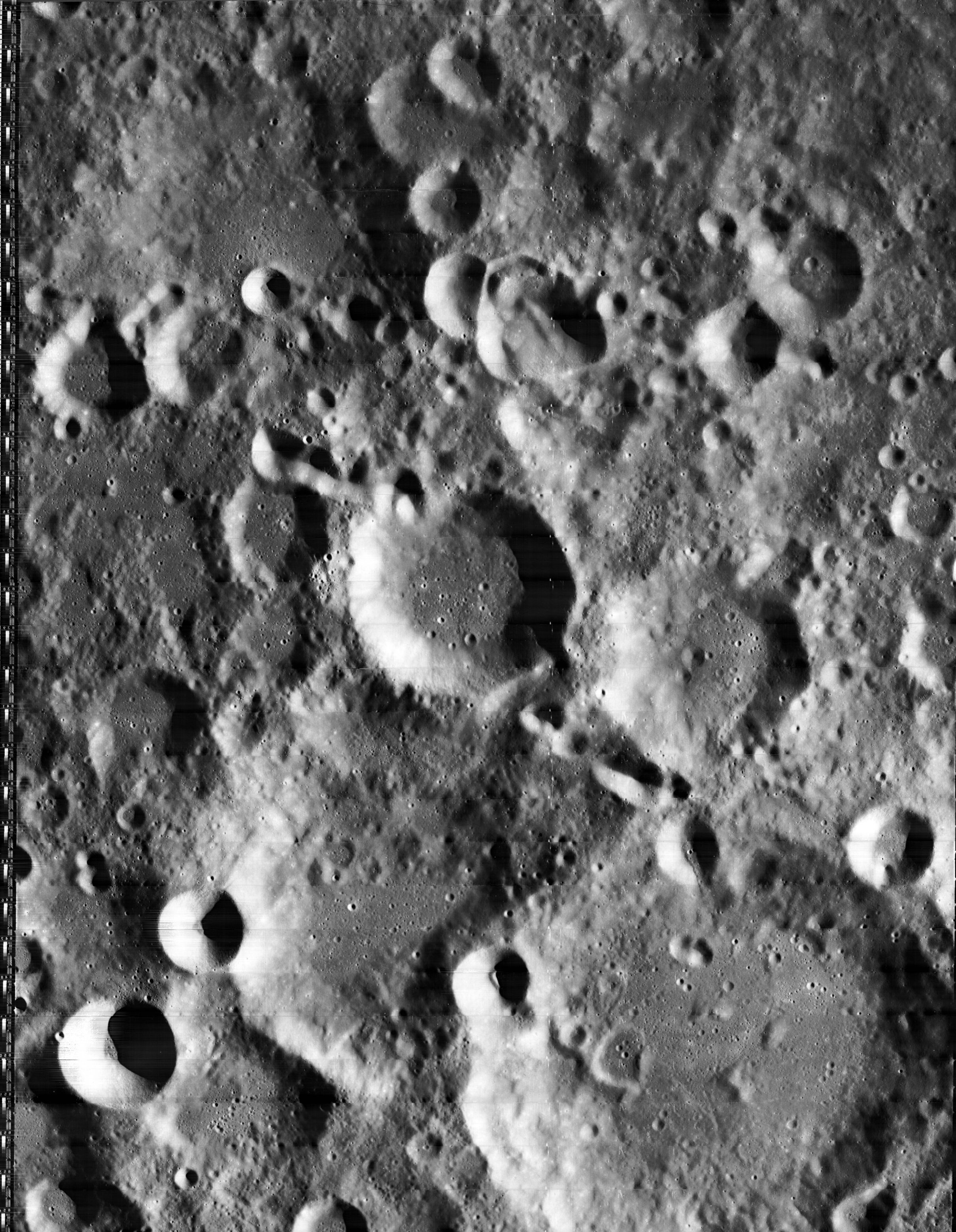
left: II-O34-H3 . right: LROC . Coriolis lies on a low plain at the farside central highlands.
Images
LPOD Photo Gallery Lunar Orbiter Images Apollo Images Apollo 10 image
LO-II 034 h3 is a HiRes scan of the above depicted Lunar Orbiter II frame, which shows Coriolis's floor in great detail (near the frame's lower right corner, south up).- DannyCaes DannyCaes Nov 11, 2012
Maps
(LAC zone 68D4) USGS Digital Atlas PDF
Description
A middle aged crater of the complex type. Erosion has smoothed away the terraces and infill has buried the original floor - only a few scatter hills remain of the central peaks. A short crater chain or rilles occurs on the northern half of the floor. - tychocrater tychocrater May 16, 2009
Description: Wikipedia
Additional Information
- Coriolis Y mapped as Copernican by USGS.
Nomenclature
Gaspard-Gustave de; French physicist (1792-1843).
LPOD Articles
Bibliography
This page has been edited 1 times. The last modification was made by - tychocrater tychocrater on Jun 13, 2009 3:24 pm - afx3u2