Bayer
Contents
Bayer
|
Lat: 51.6°S, Long: 35.0°W, Diam: 47 km, Depth: 2.44 km, Rükl: 71 |
Table of Contents
[#Bayer Bayer]
[#Bayer-Images Images]
[#Bayer-Maps Maps]
[#Bayer-Description Description]
[#Bayer-Description: Elger Description: Elger]
[#Bayer-Description: Wikipedia Description: Wikipedia]
[#Bayer-Additional Information Additional Information]
[#Bayer-Nomenclature Nomenclature]
[#Bayer-LPOD Articles LPOD Articles]
[#Bayer-Bibliography Bibliography]

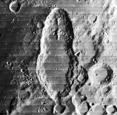
Lunar Orbiter IV image IV-155-H1
Schiller at center, Bayer at lower right, with tiny crater within.
Images
LPOD Photo Gallery Lunar Orbiter Images
Maps
(LAC zone 125A2) LAC map Geologic map
Description
Description: Elger
(IAU Directions) BAYER.--This object, 29 miles in diameter, with a terraced border rising on the E. to a height of 8,000 feet above the floor, is so closely associated with Schiller, that it may almost be regarded as forming part of it. A long lofty mountain arm, apparently connected with the E. wall of the latter, runs from the W. side of Bayer towards the N.E. There is a crater on the W. side of the interior.
Description: Wikipedia
Additional Information
Depth data from Kurt Fisher database
- Westfall, 2000: 2.44 km
- Viscardy, 1985: 2 km
- Satellite crater Bayer N is on the ALPO list of banded craters
Nomenclature
Johann Bayer (1572-1625) German lawyer, uranographer (celestial cartographer).
LPOD Articles
Bibliography
This page has been edited 1 times. The last modification was made by - tychocrater tychocrater on Jun 13, 2009 3:24 pm - afx3u2