Difference between revisions of "Büsching"
(Created page with "<div id="content_view" class="wiki" style="display: block"> =Büsching= {| class="wiki_table" | Lat: 38.0°S, Long: 20.0°E, Diam: 52 km, Depth: 1.81 km, R%C3%BCkl%2066|...") |
|||
| (One intermediate revision by the same user not shown) | |||
| Line 6: | Line 6: | ||
|} | |} | ||
<div id="toc"> | <div id="toc"> | ||
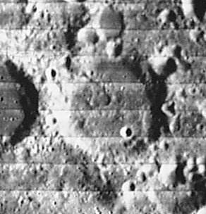
| − | + | [[Image:Busching_LO_iv_095_h2.jpg|external image Busching_LO_iv_095_h2.jpg]]<br /> ''[http://lpod.org/coppermine/displayimage.php?pos=-1736 LOIV 095 H2]''<br /> <br /> | |
| − | |||
==Images== | ==Images== | ||
[http://www.lpod.org/coppermine/thumbnails.php?album=search&type=full&search=Busching LPOD Photo Gallery] [http://www.lpi.usra.edu/resources/lunar_orbiter/bin/srch_nam.shtml?Busching%7C0 Lunar Orbiter Images] [http://www.lpi.usra.edu/resources/apollo/search/feature/?feature=Busching Apollo Images]<br /> <br /> | [http://www.lpod.org/coppermine/thumbnails.php?album=search&type=full&search=Busching LPOD Photo Gallery] [http://www.lpi.usra.edu/resources/lunar_orbiter/bin/srch_nam.shtml?Busching%7C0 Lunar Orbiter Images] [http://www.lpi.usra.edu/resources/apollo/search/feature/?feature=Busching Apollo Images]<br /> <br /> | ||
| Line 15: | Line 14: | ||
<br /> | <br /> | ||
==Description: Elger== | ==Description: Elger== | ||
| − | ''([[IAU% | + | ''([[IAU%20directions|IAU Directions]])'' BUSCHING.--A ring-plain S. of [[Zagut|Zagut]], about 36 miles in diameter, with a moderately high but irregular wall. There are several craterlets within and some low hills.<br /> <br /> |
==Description: Wikipedia== | ==Description: Wikipedia== | ||
[http://en.wikipedia.org/wiki/B%C3%BCsching_(crater) Büsching]<br /> <br /> | [http://en.wikipedia.org/wiki/B%C3%BCsching_(crater) Büsching]<br /> <br /> | ||
==Additional Information== | ==Additional Information== | ||
| − | Depth data from [[Kurt%20Fisher% | + | Depth data from [[Kurt%20Fisher%20Crater%20Depths|Kurt Fisher database]]<br /> |
* Westfall, 2000: 1.81 km | * Westfall, 2000: 1.81 km | ||
* Viscardy, 1985: 1.7 km | * Viscardy, 1985: 1.7 km | ||
| Line 33: | Line 32: | ||
<br /> <br /> | <br /> <br /> | ||
---- | ---- | ||
| − | + | </div> | |
Latest revision as of 02:43, 16 April 2018
Contents
Büsching
|
Lat: 38.0°S, Long: 20.0°E, Diam: 52 km, Depth: 1.81 km, Rükl: 66 |
Images
LPOD Photo Gallery Lunar Orbiter Images Apollo Images
Maps
(LAC zone 113A3) LAC map Geologic map
Description
Description: Elger
(IAU Directions) BUSCHING.--A ring-plain S. of Zagut, about 36 miles in diameter, with a moderately high but irregular wall. There are several craterlets within and some low hills.
Description: Wikipedia
Additional Information
Depth data from Kurt Fisher database
- Westfall, 2000: 1.81 km
- Viscardy, 1985: 1.7 km
- Cherrington, 1969: 2.4 km
- Satellite crater Busching E is on the ALPO list of banded craters
Nomenclature
Anton Friedrich Büsching (1724-1793) was a celebrated German geographer. His Erdbeschreibung ("Earth description") was the first geographical work of any scientific merit. It gives only the geography of Europe.
LPOD Articles
Bibliography
