Difference between revisions of "Amici"
(Created page with "<div id="content_view" class="wiki" style="display: block"> =Amici= {| class="wiki_table" | Lat: 9.9°S, Long: 172.1°W, Diam: 54 km, Depth: km, Rükl: ''(farside)''<br />...") |
|||
| Line 4: | Line 4: | ||
| Lat: 9.9°S, Long: 172.1°W, Diam: 54 km, Depth: km, Rükl: ''(farside)''<br /> | | Lat: 9.9°S, Long: 172.1°W, Diam: 54 km, Depth: km, Rükl: ''(farside)''<br /> | ||
|} | |} | ||
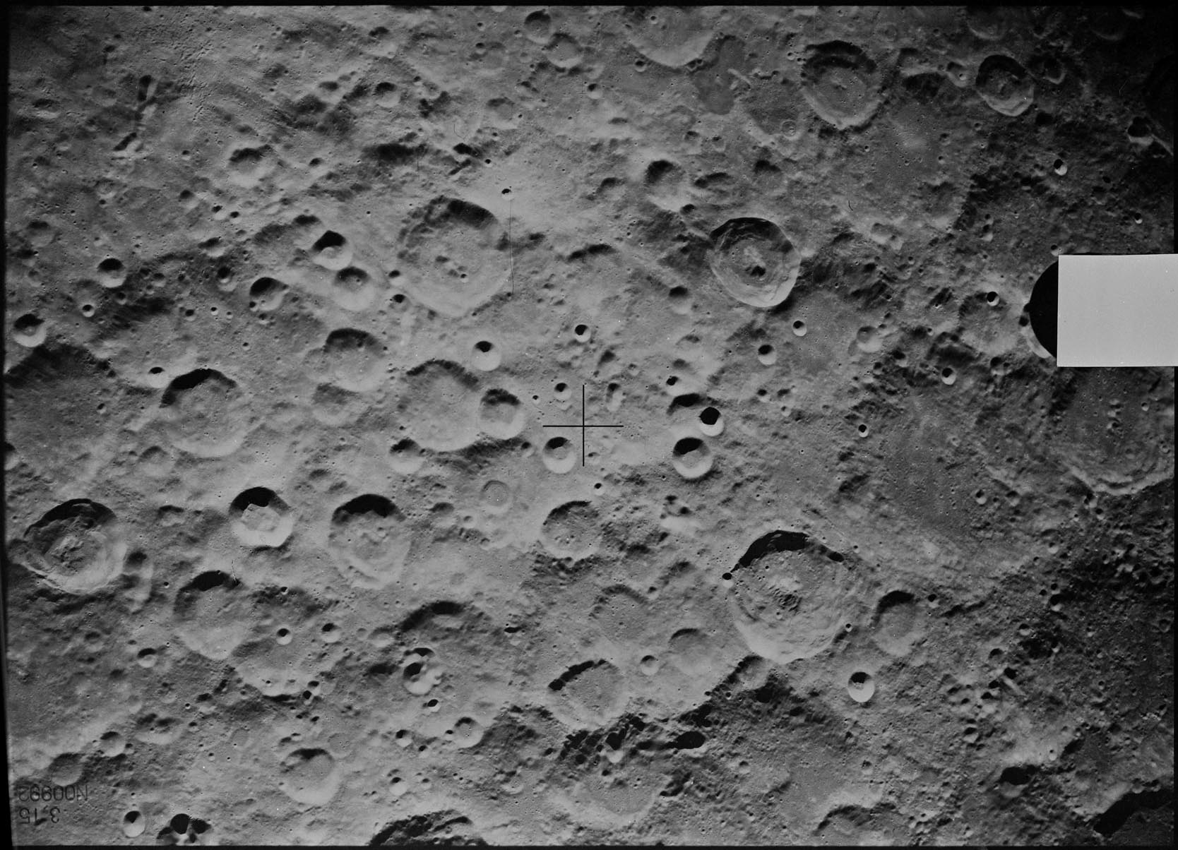
| − | [http://www.lpod.org/coppermine/displayimage.php?pid=4098&fullsize=1 [[Image:amici.jpg|amici.jpg]]][[Image:amici-color.jpg|amici-color.jpg]]<br /> left: '''''LROC''''' '''Amici''' at upper right, upper left satellite '''T'''; below from left to right satellites '''R''', '''P''' and '''M'''<br /> Right: ''[http://planetarynames.wr.usgs.gov/images/Lunar/lac_86.pdf USGS Digital Atlas - Color-coded LAC 86]''. Situated not very far from the northern rim of the [ | + | [http://www.lpod.org/coppermine/displayimage.php?pid=4098&fullsize=1 [[Image:amici.jpg|amici.jpg]]][[Image:amici-color.jpg|amici-color.jpg]]<br /> left: '''''LROC''''' '''Amici''' at upper right, upper left satellite '''T'''; below from left to right satellites '''R''', '''P''' and '''M'''<br /> Right: ''[http://planetarynames.wr.usgs.gov/images/Lunar/lac_86.pdf USGS Digital Atlas - Color-coded LAC 86]''. Situated not very far from the northern rim of the [[South%20Pole-Aitken%20basin|South Pole Aitken Basin]], '''Amici''' lies in very rugged terrain. A slight peak-like shadow in the central region can be seen in the left image above, but like the crater itself, overall degradation of the crater and possible peak has occcured.<br /> <br /> <div id="toc"> |
=Table of Contents= | =Table of Contents= | ||
<div style="margin-left: 1em">[#Amici Amici]</div><div style="margin-left: 2em">[#Amici-Images Images]</div><div style="margin-left: 2em">[#Amici-Maps Maps]</div><div style="margin-left: 2em">[#Amici-Description Description]</div><div style="margin-left: 2em">[#Amici-Description: Wikipedia Description: Wikipedia]</div><div style="margin-left: 2em">[#Amici-Additional Information Additional Information]</div><div style="margin-left: 2em">[#Amici-Nomenclature Nomenclature]</div><div style="margin-left: 2em">[#Amici-LPOD Articles LPOD Articles]</div><div style="margin-left: 2em">[#Amici-Bibliography Bibliography]</div></div> | <div style="margin-left: 1em">[#Amici Amici]</div><div style="margin-left: 2em">[#Amici-Images Images]</div><div style="margin-left: 2em">[#Amici-Maps Maps]</div><div style="margin-left: 2em">[#Amici-Description Description]</div><div style="margin-left: 2em">[#Amici-Description: Wikipedia Description: Wikipedia]</div><div style="margin-left: 2em">[#Amici-Additional Information Additional Information]</div><div style="margin-left: 2em">[#Amici-Nomenclature Nomenclature]</div><div style="margin-left: 2em">[#Amici-LPOD Articles LPOD Articles]</div><div style="margin-left: 2em">[#Amici-Bibliography Bibliography]</div></div> | ||
| Line 13: | Line 13: | ||
<br /> | <br /> | ||
==Maps== | ==Maps== | ||
| − | ''([ | + | ''([[LAC%20zone|LAC zone]] 86C2)'' [http://planetarynames.wr.usgs.gov/images/Lunar/lac_86.pdf USGS Digital Atlas PDF]<br /> <br /> |
==Description== | ==Description== | ||
<br /> | <br /> | ||
Revision as of 15:39, 15 April 2018
Contents
Amici
| Lat: 9.9°S, Long: 172.1°W, Diam: 54 km, Depth: km, Rükl: (farside) |


left: LROC Amici at upper right, upper left satellite T; below from left to right satellites R, P and M
Right: USGS Digital Atlas - Color-coded LAC 86. Situated not very far from the northern rim of the South Pole Aitken Basin, Amici lies in very rugged terrain. A slight peak-like shadow in the central region can be seen in the left image above, but like the crater itself, overall degradation of the crater and possible peak has occcured.
Table of Contents
[#Amici Amici]
[#Amici-Images Images]
[#Amici-Maps Maps]
[#Amici-Description Description]
[#Amici-Description: Wikipedia Description: Wikipedia]
[#Amici-Additional Information Additional Information]
[#Amici-Nomenclature Nomenclature]
[#Amici-LPOD Articles LPOD Articles]
[#Amici-Bibliography Bibliography]
Images
LPOD Photo Gallery Lunar Orbiter Images
- View of color-coded relief map draped over three-dimensional Moon on NASA World Wind
- Frame 53, made by ZOND 8, shows Amici near the frame's left margin, at the same height of the frame's central cross. Research: Danny Caes
Maps
(LAC zone 86C2) USGS Digital Atlas PDF
Description
Description: Wikipedia
Additional Information
Nomenclature
- Named for Giovanni Battista Amici (March 25, 1786 - April 10, 1863), an Italian astronomer and microscopist who invented the dipleidoscope, an instrument used to determine true noon. His name is best known for the improvements he effected in the mirrors of reflecting telescopes and especially in the construction of the microscope. Two frequently encountered kinds of optical prisms are named after him.
LPOD Articles
Bibliography
This page has been edited 1 times. The last modification was made by - tychocrater tychocrater on Jun 13, 2009 3:24 pm - afx3u2