Al-Tusi
Contents
King Y
(formerly known as Al-Tusi, a discontinued(?) IAU name)
| Lat: 6.5°N, Long: 119.8°E, Diam: 48 km, Depth: km, Rükl: (farside) |
Table of Contents
[#King Y King Y]
[#King Y-Images Images]
[#King Y-Maps Maps]
[#King Y-Description Description]
[#King Y-Description: Wikipedia Description: Wikipedia]
[#King Y-Additional Information Additional Information]
[#King Y-Nomenclature Nomenclature]
[#King Y-LROC Articles LROC Articles]
[#King Y-Bibliography Bibliography]

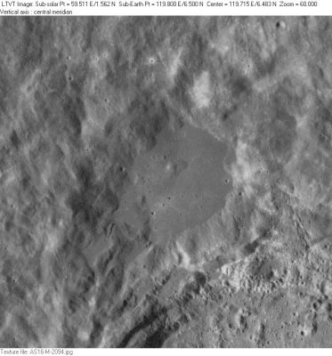
AS16-M-2094 King Y (with part of 76-km King to its southeast) nearly fills this Apollo view, but its smooth floor is more obvious than its broad sloping walls.
Images
LPOD Photo Gallery Lunar Orbiter Images Apollo Images
- King Y (the LTO's Al-Tusi) was also photographed on color Hasselblad film, such as Apollo 16's frames AS16-120-19265 (near the frame's lower left corner), 19266 (left of frame's centre), 19267 (near the frame's upper left corner), and 19273 (central).
- Research orbital Apollo 16 photography: Danny Caes.
Maps
(LAC zone 65D2) USGS Digital Atlas PDF LTO map Topophotomap
IAU page
Description
Description: Wikipedia
Additional Information
Nomenclature
- This farside satellite feature of King was given its present name by Ewen Whitaker in NASA RP-1097 (1982). However, it had previously been given the distinctive name of Al-Tusi when, in 1976, the IAU approved that provisional name for the crater at 7.0 N, 120.0 W "as assigned", presumably on LTO-65C1 and LTO-65D2 (IAU Transactions XVIB). Al-Tusi was also incorporated into several minor feature names introduced on Topophotomap 65D2(S1). However, as Whitaker notes in his list of invalid names, the "Al-Tusi" mentioned in the IAU citation is the same person as the one already honored by the nearside crater Nasireddin. The name Al-Tusi (for the farside features) seems to have been dropped, for that name does not appear in the on-line IAU Planetary Gazetteer. But since there is no further mention of it in the IAU Transactions, exactly when and where it was dropped is unclear. Whitaker's own system of lettered craters for the farside (as published in NASA RP-1097) was adopted by the IAU in 2006 (IAU Transactions XXVI). - JimMosher JimMosher
LROC Articles
An Impact Melt Veneer in the Highlands
Bibliography
This page has been edited 1 times. The last modification was made by - tychocrater tychocrater on Jun 13, 2009 3:24 pm - afx4 - mrx1