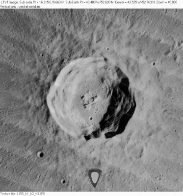
Harpalus
Contents
Harpalus
|
Lat: 52.6°N, Long: 43.4°W, Diam: 39 km, Depth: 3.6 km, Rükl: 2, [/Stratigraphy Eratosthenian] |
Table of Contents

LO-IV-158H The triangular feature near the bottom margin is a defect in the [/Lunar%20Orbiter Lunar Orbiter] on-board development.
Images
LPOD Photo Gallery Lunar Orbiter Images
- Lunar Orbiter stereo view
Trivia:
An imaginary convoy of lunar explorers, near and on the floor of Harpalus, is seen in an extraordinary painting which was made by Chesley Bonestell, for the magazine Collier's (see: the ninth painting on page Collier's 2 in Fabio Femino's Fantascienza website). - DannyCaes DannyCaes Jan 13, 2008
Maps
([/LAC%20zone LAC zone] 11D1) LAC map Geologic map
Description
Description: Elger
([/IAU%20Directions IAU Directions]) HARPALUS.--A conspicuous ring-plain, about 14 miles in diameter, on the N.W. of [/Foucault Foucault], with a floor sinking 13,000 feet below the surrounding surface. As the cubic contents of the border and glacis are quite inadequate to account for it, we may ask, what has become of the material which presumably once filled this vast depression? Harpalus has a bright central mountain.
Description: Wikipedia
Additional Information
- Depth data from [/Kurt%20Fisher%20crater%20depths Kurt Fisher database]
- Westfall, 2000: 3.6 km
- Viscardy, 1985: 2.85 km
- Cherrington, 1969: 2.98 km
- Central peak height
- [/Sekiguchi%2C%201972 Sekiguchi, 1972]: 0.4 km, 0.3 km "Two mounds standing side by side"
- 0.2 km "A smaller hill to the east of the [central peaks]." - fatastronomer fatastronomer
- [/Sekiguchi%2C%201972 Sekiguchi, 1972]: 0.4 km, 0.3 km "Two mounds standing side by side"
- Included in [/ALPO%20list%20of%20bright%20ray%20craters ALPO list of bright ray craters]
- Stratigraphy changed from Copernican to Eratosthenian based on Galileo data and crater counts (McEwen et al, 1993)
- TSI = 30, CPI = 30, FI = 20; MI =80 [/Smith%20and%20Sanchez%2C%201973 Smith and Sanchez, 1973]
Nomenclature
- The name Harpalus has continued unchanged since its original use for this feature on [/Riccioli Riccioli]'s map ([/Whitaker Whitaker], p. 212).
- This crater was called Morini by Van Langren.
- According to the [/IAU%20Planetary%20Gazetteer IAU Planetary Gazetteer] this crater is named for Harpalus (unkn-c. 460 B.C.), a Greek astronomer who made refinements to the luni-solar cycle in the time between [/Cleostratus Cleostratus] and [/Meton Meton]. The original name has sometimes (almost certainly incorrectly) been attributed to a later and more famous Harpalus, who was a colorful friend of Alexander the Great, but with no known astronomical connection. - JimMosher JimMosher
- Harpalus Lambda (hill east-southeast of Harpalus, north of Foucault), Harpalus Gamma and Harpalus Xi (two hills west-northwest of Harpalus). See Chart 1 in the Times Atlas of the Moon.
LPOD Articles
Bibliography
This page has been edited 1 times. The last modification was made by - tychocrater tychocrater on Jun 13, 2009 3:24 pm - afx3u2