Rima G. Bond
Contents
[hide]Rima G. Bond
|
Lat: 33.3°N, Long: 35.5°E, Length: 168 km, Depth: km, Rükl: 15 |
Table of Contents
[#Rima G. Bond Rima G. Bond]
[#Rima G. Bond-Images Images]
[#Rima G. Bond-Maps Maps]
[#Rima G. Bond-Description Description]
[#Rima G. Bond-Description: Wikipedia Description: Wikipedia]
[#Rima G. Bond-Additional Information Additional Information]
[#Rima G. Bond-Nomenclature Nomenclature]
[#Rima G. Bond-LPOD Articles LPOD Articles]
[#Rima G. Bond-Bibliography Bibliography]

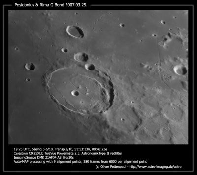
Oliver Pettenpaul, Posidonius & Rima G. Bond (near the right margin of the image).
Images
LPOD Photo Gallery Lunar Orbiter Images Apollo Images
Maps
(LAC zone 27D4) LAC map Geologic map
Description
Description: Wikipedia
Additional Information
- Rima G. Bond runs west of craters Hall and G. Bond. The northern part of it at Lacus Somniorum.
- Chart 8 (page 29) in the 21st Century Atlas of the Moon (Wood/ Collins) shows Rima G. Bond pretty well (see location 1/2-D; G. Bond Rille).
Nomenclature
- Named from nearby crater. (G. Bond)
- According to Chart 21 in the Times Atlas of the Moon, this rille (west of craters Hall and G. Bond) is called Rima G. Bond I (the first G. Bond rille). However, on that chart there is no trace of a second (II) or a third (III) Rima G. Bond. - DannyCaes DannyCaes Feb 4, 2014
- There seems to be some confusion when the name Rima Bond is mentioned. Keep in mind that there is also a rille on the floor of W. Bond, although the name of this rille (Rima W. Bond) is not officially recognized by the IAU. - DannyCaes DannyCaes Jul 26, 2014
LPOD Articles
Rille Finder
Unknown Rille
Shadow Magnification
Bibliography
This page has been edited 1 times. The last modification was made by - tychocrater tychocrater on Jun 13, 2009 3:24 pm - afx3u2