Promontorium Lavinium
Contents
Promontorium Lavinium
(discontinued(?) IAU name)
| Lat: 14.9°N, Long: 49.5°E, Diameter: km, Depth: km, Rukl: 26 | |
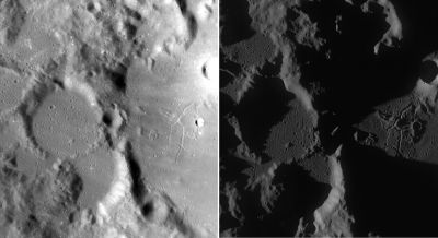
Right: Two LROC views (WAC No.'s M119530553ME and M117169050ME) of the region under different lighting conditions. Both images calibrated by LROC_WAC_Previewer.
Table of Contents
[#Promontorium Lavinium Promontorium Lavinium]
[#Promontorium Lavinium-Images Images]
[#Promontorium Lavinium-Maps Maps]
[#Promontorium Lavinium-Description Description]
[#Promontorium Lavinium-Additional Information Additional Information]
[#Promontorium Lavinium-Nomenclature Nomenclature]
[#Promontorium Lavinium-LPOD Articles LPOD Articles]
[#Promontorium Lavinium-Bibliography Bibliography]
Images
LPOD Photo Gallery Lunar Orbiter Images
Although not mentioned in the LPI's list, it (Promontorium Lavinium) WAS photographed during the Apollo program! - DannyCaes DannyCaes May 8, 2010
- Apollo 17's orbital ITEK-panoramic frame AS17-P-2259 and its stereo-companion AS17-P-2264 show Promontorium Lavinium near the left margins of both frames (one doesn't have to scroll to the right, the promontorium is immediately detectable).
Research: Danny Caes
Maps
(LAC zone 61B2) LAC map Geologic map LTO map
Description
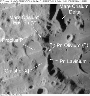
Bounding the tiny break in the western rim of the Crisium Basin are two headlands that almost meet. To the north is the area east of the crater Proclus P, and to the south is the eastern wall of Glaisher X. Each of these headlands was named in the late 1800's by the English selenographer William Birt. He called the northern one Promontorium Olivium and the southern Promontorium Lavinium. Both of these names were included in Named Lunar Formations and in the System of Lunar Craters, but do not appear in the current list of IAU names. Prom. Olivium is broad and flatly rounded in cross-section, it appears to be the continuation of the Crisium Basin rim. Prom. Lavinium is narrower with a more V-shaped profile - it casts the more dramatic shadow under low illumination. These are conspicuous landmarks and these names should be re-instated.
Additional Information
Nomenclature
- The name Promontorium Lavinium appeared both in the Collated List (1913) and in Named Lunar Formations (1935, where it was Catalog #100). It also appears on maps A3 and A4 of the System of Lunar Craters, but it was not labeled on the contemporaneous LAC maps, and does not appear in later lists of IAU-approved nomenclature. However, it also does not appear on any published list of deletions, and does not appear to have been formally dropped.
LPOD Articles
Sunset on the Wasatch Mountains
Wilkins and the Bridge
Bibliography
This page has been edited 1 times. The last modification was made by - tychocrater tychocrater on Jun 13, 2009 3:24 pm - mfx3

