Planitia Descensus
Contents
Planitia Descensus (landingsite of Luna 9)
|
Lat: 7.1°N, Long: 64.4°W, Diam: 0 km, Depth: km, Rükl: 28 |
Table of Contents
[#Planitia Descensus (landingsite of Luna 9) Planitia Descensus (landingsite of Luna 9)]
[#Planitia Descensus (landingsite of Luna 9)-Images Images]
[#Planitia Descensus (landingsite of Luna 9)-Maps Maps]
[#Planitia Descensus (landingsite of Luna 9)-Description Description]
[#Planitia Descensus (landingsite of Luna 9)-Description: Wikipedia Description: Wikipedia]
[#Planitia Descensus (landingsite of Luna 9)-Additional Information Additional Information]
[#Planitia Descensus (landingsite of Luna 9)-Nomenclature Nomenclature]
[#Planitia Descensus (landingsite of Luna 9)-LPOD Articles LPOD Articles]
[#Planitia Descensus (landingsite of Luna 9)-Bibliography Bibliography]

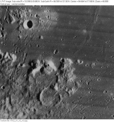
LO-IV-162H The crater in the upper left is Cavalerius F.
Images
LPOD Photo Gallery Lunar Orbiter Images
- Frame 3214, made by Lunar Orbiter 3, shows an oblique view of Planitia Descensus and crater Galilaei in the distance.
- Apollo 17's NIKON-camera photographs AS17-158-23895 and 23896 show Planitia Descensus near the upper margins of both frames (made in earthlight circumstances).
- Research Lunar Orbiter 3 and Apollo 17 photography: Danny Caes
Maps
(LAC zone 56D2) LAC map Geologic map
Description
This IAU name commemorates the February 3, 1966 landing site of Luna 9, the first spacecraft from Earth to successfully soft-land on the Moon and return images from it. In the Lunar Orbiter image shown here, the official IAU coordinates are marked by a white cross on the peak to the right of center, but the actual landing was in a mare area. Many charts place the Luna 9 landing site in the plain immediately to the left of the cross. However NASA SP-241, which may be more definitive, places it to the right, almost touching the left side of the bright crescent. The position shown in SP-241 is approximately 7.19°N, 64.18°W

  Although Planitia means "plain" the name is thought to refer, like Statio Tranquillitatis, to the landing site only, a feature of zero size, and not to the surrounding region.

 - JimMosher JimMosher
Description: Wikipedia
Additional Information
- Luna 9 was the first mission to establish that the lunar surface (at least at that point) could bear the weight of a spacecraft.
- Robert Christy gives the landing site coordinates as 7.13 degrees north, 60.36 degrees west (the latter, giving a location near Reiner Gamma, is almost certainly a typo).
- John Walker gives the landing site coordinates as 7.08 degrees north, 64.37 degrees west (a position on the peak, very close to the cross).
Nomenclature
- Luna 9 landing site ("plain of descent").
- Called Sinus Adlunationis on the Complete Moon Map of 1969 by the Sternberg Astronomy Institute. Research: Danny Caes
LPOD Articles
Bibliography
- Jaffe, L. D.; Scott, R. F. 1966 Lunar Surface Strength: Implications of Luna 9 Landing SCIENCE vol. 153, 407-408.
This page has been edited 1 times. The last modification was made by - tychocrater tychocrater on Jun 13, 2009 3:24 pm - afx3u2