Sita
Contents
Sita (craterlet in King)
| Lat: 4.6°N, Long: 120.8°E, Diam: 2 km, Depth: km, Rükl: (farside) |
Table of Contents
[#Sita (craterlet in King) Sita (craterlet in King)]
[#Sita (craterlet in King)-Images Images]
[#Sita (craterlet in King)-Maps Maps]
[#Sita (craterlet in King)-Description Description]
[#Sita (craterlet in King)-Description: Wikipedia Description: Wikipedia]
[#Sita (craterlet in King)-Additional Information Additional Information]
[#Sita (craterlet in King)-Nomenclature Nomenclature]
[#Sita (craterlet in King)-LPOD Articles LPOD Articles]
[#Sita (craterlet in King)-Bibliography Bibliography]

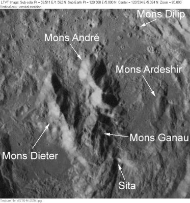
This Apollo 16 view of the floor of the crater King shows the location of Sita -- a fresh impact crater with a spray of bright ejecta to the east. It appears to have hit on the steep slope of what appears to be a landslide from the south rim, terminating near the part of the central peaks known as Mons Ganau. Other IAU-named features in this view are Mons André, Mons Dieter, Mons Ardeshir, and Mons Dilip.
Images
LPOD Photo Gallery Lunar Orbiter Images Apollo Images
Maps
(LAC zone 65C1) LTO map Topophotomap
Description
Description: Wikipedia
Additional Information
Nomenclature
Indian female name.
- Sita is a Minor Feature whose name was originally intended only for use in connection with Topophotomap 65C1/S1, on which it is plotted.
- Sita is also the name of an asteroid: 244 Sita- DannyCaes DannyCaes Mar 24, 2013
LPOD Articles
Bibliography
This page has been edited 1 times. The last modification was made by - tychocrater tychocrater on Jun 13, 2009 3:24 pm - afx3u2