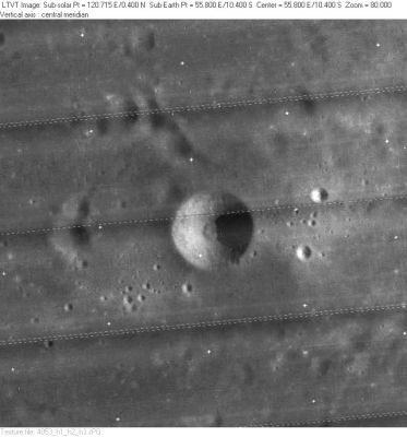
Al-Marrakushi
Contents
Al-Marrakushi
(formerly [/Langrenus Langrenus] D)
|
Lat: 10.4°S, Long: 55.8°E, Diam: 8 km, Depth: 1.11 km, [/R%C3%BCkl%2048 Rükl: 48] |
Table of Contents
[#Al-Marrakushi Al-Marrakushi]
[#Al-Marrakushi-Images Images]
[#Al-Marrakushi-Maps Maps]
[#Al-Marrakushi-Description Description]
[#Al-Marrakushi-Description: Wikipedia Description: Wikipedia]
[#Al-Marrakushi-Additional Information Additional Information]
[#Al-Marrakushi-Nomenclature Nomenclature]
[#Al-Marrakushi-LPOD Articles LPOD Articles]
[#Al-Marrakushi-Bibliography Bibliography]

LO-IV-053H
Images
LPOD Photo Gallery Lunar Orbiter Images Apollo Images
- The first orbital Hasselblad photograph of Apollo 8's Magazine 13-E (AS8-13-2215) shows an oblique southward looking close up of bowl-shaped crater Langrenus D (Al-Marrakushi) in the southern part of Mare Fecunditatis.
- An interesting mosaic (AS8-13-2215 to 2227), created by David Woods and Frank O'Brien of the Apollo 8 Flight Journal, shows the location of Al-Marrakushi related to the known region of Goclenius and Colombo (southward looking view).
- Al Marrakushi's odd surrounding high-albedo streaks (ejecta rays from Langrenus) are noticeable on several oblique south looking frames made by the orbital Mapping/Metric Fairchild camera of Apollo 15. Of these, AS15-M-2533 shows Al-Marrakushi near the centre of the frame.
- Oblique southward looking close up photographs of Al-Marrakushi were also made during the mission of Apollo 16, such as orbital ITEK-panoramic frames AS16-P-4442 and AS16-P-4447. In both frames, bowl-shaped crater Al-Marrakushi is noticeable near the left margins. Note also the bright ray-like material from its larger neighbour in the east: Langrenus.
- Apollo 16's Fairchild camera frame AS16-M-0671 shows Al-Marrakushi slightly to the left of the frame's centre.
- Research orbital Apollo photography: Danny Caes
Maps
([/LAC%20zone LAC zone] 80D2) LAC map Geologic map LTO map
Description
Description: Wikipedia
Additional Information
- Depth data from [/Kurt%20Fisher%20crater%20depths Kurt Fisher database]
- Westfall, 2000: 1.11 km
- Viscardy, 1985: 1.11 km
Nomenclature
- Named for Abu `Ali al-Hasan Ibn `Ali al-Marrakushi (fl. c. A.D. 1281/1282), a Moroccan astronomer and mathematician.
- The name [/Langrenus Langrenus] D was part of the original [/IAU%20nomenclature IAU nomenclature] of [/Blagg%20and%20M%C3%BCller Blagg and Müller] (Catalog Entry 4691). It was attributed to Mädler.
- This replacement name for a formerly [/lettered%20crater lettered crater] was provisionally introduced on LTO-80D2 (Nov. 1974), for which it served as the chart title. It was approved in 1976 ([/IAU%20Transactions%20XVIB IAU Transactions XVIB]). - JimMosher JimMosher
LPOD Articles
Bibliography
This page has been edited 1 times. The last modification was made by - tychocrater tychocrater on Jun 13, 2009 3:24 pm - afx3u2