Rima Archytas
Contents
Rima Archytas
|
Lat: 53.0°N, Long: 3.0°E, Length: 90 km, Depth: km, [/R%C3%BCkl%204 Rükl: 4] |
Table of Contents
[#Rima Archytas Rima Archytas]
[#Rima Archytas-Images Images]
[#Rima Archytas-Maps Maps]
[#Rima Archytas-Description Description]
[#Rima Archytas-Description: Wikipedia Description: Wikipedia]
[#Rima Archytas-Additional Information Additional Information]
[#Rima Archytas-Nomenclature Nomenclature]
[#Rima Archytas-LPOD Articles LPOD Articles]
[#Rima Archytas-Bibliography Bibliography]

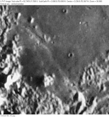
Consolidated Lunar Atlas -- Plate A5 This view is centered on a portion of [/Mare%20Frigoris Mare Frigoris] north of [/Vallis%20Alpes Vallis Alpes] and southwest of [/Protagoras Protagoras]. The graben-like channel of Rima Archytas can be seen passing between some low hills and unnamed craters in the upper left (at about 53.8°N/2.7°E). On still lower sun angle views it appears to extend south as a very shallow trough.
Images
LPOD Photo Gallery Lunar Orbiter Images Apollo Images
Maps
([/LAC%20zone LAC zone] 12C2) LAC map Geologic map
Description
Description: Wikipedia
Additional Information
Nomenclature
- Named after nearby crater. ([/Archytas Archytas])
- Although a rille associated with [/Archytas Archytas] (Archytas I) was included in the original 1935 IAU nomenclature of [/Blagg%20and%20M%C3%BCller Blagg and Müller], Rima Archytas is among the many rille names listed in the [/IAU%20Planetary%20Gazetteer IAU Planetary Gazetteer] as having been approved in 1964. The [/System%20of%20Lunar%20Craters System of Lunar Craters] plotted Rima Archytas I as consisting of just the short channel visible in the Consolidated Lunar Atlas photo shown above (shown as about 6-km wide and 56 km long); however, as indicated in the figure caption, there is a shadowy extension of it to the south-southeast visible in still lower sun views. LAC-12 shows Rima Archytas I extending over this greater length, which seems to be a shallow trough. The on-line [/IAU%20Planetary%20Gazetteer IAU Planetary Gazetteer] seems to have adopted this latter definition, moving the center southward and giving Rima Archytas a “diameter” of 90 km (as quoted in the present title line). The best available Lunar Orbiter photos (taken at a sun angle of about 19°) reveal only a channel about 4 km wide and less than 20 km long near the center of the region plotted on the [/System%20of%20Lunar%20Craters System of Lunar Craters] charts. With the higher sun angle they are unable to confirm any extension of this channel to the north or south. - JimMosher JimMosher
LPOD Articles
Bibliography
This page has been edited 1 times. The last modification was made by - tychocrater tychocrater on Jun 13, 2009 3:24 pm - afx3u2