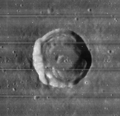
Ross
Contents
[hide]Ross
|
Lat: 11.7°N, Long: 21.7°E, Diam: 24 km, Depth: 1.84 km, Rükl: 35 |
Images
LPOD Photo Gallery Lunar Orbiter Images Apollo Images
Apollo 15's southern oblique look at Ross: AS15-P-9885.
Maps
(LAC zone 60B4) LAC map Geologic map LM map LTO map
Description
Description: Elger
(IAU Directions) ROSS.-- A somewhat larger ring-plain of irregular form, on the N.E. of Maclear. There are gaps on the bright S.E. border and a crater on the S.W. wall. The central mountain is an easy feature.
Description: Wikipedia
Additional Information
- Depth data from Kurt Fisher database
- Westfall, 2000: 1.84 km
- Viscardy, 1985: 1.8 km
- Cherrington, 1969: 1.79 km
- Ross and Ross D are thermal anomaly craters, implying youthful ages - Moore et al, 1980
- TSI = 25, CPI = 10, FI = 15; MI =60 Smith and Sanchez, 1973
- "Temporary hill", 3 km in diameter and casting a shadow, seen by Thomas A. Cragg on 16th july 1964 southeast of Ross D (source: V.A.Firsoff's The Old Moon and the New (1969), page 183).- DannyCaes May 18, 2012
- Patrick Moore: To the northeast of Ross is Ross D, where TLP have been reported, though in my view the evidence is very slender (source: Patrick Moore's New Guide to the Moon (1976), page 249).- DannyCaes May 19, 2012
- Possible swirl formation to the west-northwest of Ross, at 12°30' North/ 20°30' East. Page 120 (LAC 60) of the Clementine Atlas of the Moon shows something of this (possible) swirl.- DannyCaes Aug 5, 2013
- South-southwest of Ross H', near four unnamed dome-like formations (north-northwest of the large dome Arago Alpha), is (or should be) the impact location of Ranger 6, which was an unsuccessful attempt to make close-up photographs of the moon while the probe descended toward the lunar surface.
The exact coordinates of Ranger 6s impact location are: 9°24' North/ 21°30' East.
Note that chart 35 in Antonin Rukl's Atlas of the Moon doesn't show the location of Ranger 6. According to chart 44 in the Times Atlas of the Moon, Ross H is the nearest one of the officially named lunar formations, north-northeast of the impact location of Ranger 6. Additional research Danny Caes
The field of Irregular Mare Patches (IMPs) south-southeast of Ross E (known as Ross E 1)
The exact coordinates of this IMP field are: LAT 10.460 / LON 23.547 (south-southeast of the bowl shaped crater Ross E).
Nomenclature
- The IAU name currently honors two men:
- James Clark Ross (1800-1862), a British explorer.
- Frank Elmore Ross (1874-1966), an American astronomer and optician.
- This crater was Catalog number 531 in the original IAU nomenclature of Named Lunar Formations, where the name Ross is attributed to Beer and Mädler.
- Frank E. Ross was added as a second honoree in Menzel, 1971.
- Named Lunar Formations included a rille associated with Ross which is now regarded as part of Rimae Maclear.
- Ross Mu (the hill east of Ross, west of Carrel) (see page 115 in Tony Dethier's Maanmonografieen).
- Might be interesting to know, or to add: Andrew Ross (1798-1859; English lens maker), see page Those connected in some way with the Craig Telescope. - DannyCaes Jul 20, 2015
LPOD Articles
Bibliography
Hill, Harold. A Portfolio of Lunar Drawings, pages 10, 11.
