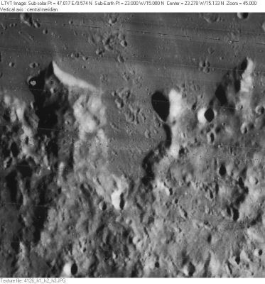
Pietrosul Bay
Contents
Pietrosul Bay
(discontinued IAU name)
|
Lat: 15.2°N, Long: 23.3°W, Diam: 45 km, Height: km, Rükl 20 |
LO-IV-126 Pietrosul Bay is the vase-shaped region in the center of the frame. The small circular crater to its right is Gay-Lussac C.
Images
LPOD|Photo Gallery images Lunar Orbiter Images Apollo Images
Maps
(LAC zone 58A2) LAC map Geologic map
Description
This once-named protrusion of Mare Imbrium into the Carpathian Mountains between T. Mayer and Gay-Lussac is no longer part of the IAU Nomenclature.
Additional Information
Nomenclature
- Named for a region in the terrestrial Carpathians.
- This name was introduced as “Pietrosul Bucht” by Krieger and König. It was modified to “Pietrosul Bay” for inclusion in the original IAU nomenclature of 1935 as prepared by Blagg and Müller. The name was deleted by Kuiper et al., whose changes to Blagg and Müller (published in the Photographic Lunar Atlas) were approved by the IAU in 1961. (Whitaker, p. 226)
Faits Divers
- Pietrosul in music: Hora de la Pietrosu (Ionica Minune) (a wonderful example of the most swinging music ever made!). - DannyCaes Apr 23, 2017
LPOD Articles
Bibliography
Printed as Pietrosul baai on the fourth quadrant (the northwest quadrant) of the greenish colored moonmap in A.J.M.Wanders's book Op Ontdekking in het Maanland (Het Spectrum, 1949).- DannyCaes Jan 13, 2013
