Kira
Contents
Kira (craterlet in Patsaev Q, aka Chenier)
| Lat: 17.6°S, Long: 132.8°E, Diam: 3 km, Depth: km, Rükl: (farside) |
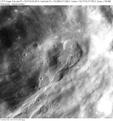
AS15-M-0305 This is a closeup of a flow structure on the western floor of Patsaev Q (aka Chenier). The central pit to which the name Kira applies is the dark feature in the center of the frame.
Images
LPOD Photo Gallery Lunar Orbiter Images Apollo Images
Maps
(LAC zone 102A1) LTO map Topophotomap
Description
This is an odd volcanic feature on the floor of Patsaev Q (Patsaev Q was provisionally called “Cheniér” on the LTO and Topophotomap – a name that was never adopted by the IAU). It consists of dome-like flows around a central pit. The flows cover a diameter of about 10 km, but judging from its stated dimension, the IAU name applies only to the central caldera.
Description: Wikipedia
Additional Information
Nomenclature
- Russian female first name. This is a generic name, and does not honor any person in particular.
- According to NASA RP-1097, Kira is a Minor Feature whose name was originally intended only for use in connection with Topophotomap 102A1/S1(on which it is plotted). It was among 95 such names from the Topophotomaps that were approved by the IAU and became part of the official nomenclature in 1979 (IAU Transactions XVIIB).
- Kira is the most eastern one of the far side's small formations which have generic "first names".- DannyCaes Jul 8, 2010
LPOD Articles
Bibliography
