Ivan
Contents
Ivan
(formerly Prinz B)|
Lat: 26.9°N, Long: 43.3°W, Diam: 4 km, Depth: 0.59 km, Rükl: 19 |
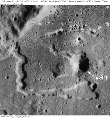
LO-V-188M Ivan is about 20-km NNE of Vera, another pit in the Rimae Prinz area. Its connection to a particular major rille is much less apparent than for Vera.
WARNING: the odd grey spots in the upper half of the top image are not true topographical formations, they were created on the photographic film aboard L.O.5. (Lunar Orbiter 5). These spots are NOT related to the Irregular Mare Patches (IMPs) described below.- DannyCaes Oct 21, 2014
Images
LPOD Photo Gallery Lunar Orbiter Images Apollo Images
- Lunar Orbiter 5's frame 189-h1 shows a close up of Ivan (Prinz B) near the photograph's upper margin.- DannyCaes Mar 22, 2014
Maps
(LAC zone 39A3) LAC map Geologic map LM map LTO map
Description
Description: Wikipedia
Additional Information
Depth data from Kurt Fisher database
- Westfall, 2000: 0.59 km
- Viscardy, 1985: 0.73 km
Cluster of small irregular mare patches (IMPs) north-northeast of Prinz, east of Ivan
- Prinz 1, at LAT 26.79 / LON -42.96 (east of Ivan, immediately west of Rima Handel)(northwest of its bowl-shaped "source").- DannyCaes Oct 21, 2014
Nomenclature
Russian male name.
- According to NASA RP-1097, "Ivan" is a Minor Feature whose name was originally intended only for use in connection with Topophotomap 39A3/S1(on which it is plotted).
LPOD Articles
Bibliography
