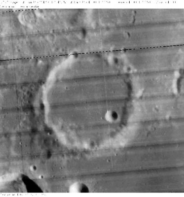
Cook
Contents
Cook
|
Lat: 17.5°S, Long: 48.9°E, Diam: 46 km, Depth: 1.12 km, Rükl: 59 |
LO-IV-060 The 6-km crater on the floor is Cook A. The craters partially visible along the lower margin are 36-km Monge and 9-km Cook G.
Images
LPOD Photo Gallery Lunar Orbiter Images Apollo Images
- Although there seem to be no orbital Apollo photographs in the LPI's list for Cook, there are several of Apollo 16's south looking Fairchild-camera frames which show the dark floor of that crater! One of those frames is AS16-M-0676, which shows Cook near the central part of the curved horizon. In this frame, Cook is the crater with the small bright bowl-shaped craterlet on its floor.
Research: Danny Caes.
Maps
(LAC zone 97B2) LAC map Geologic map
Description
Description: Elger
(IAU Directions) COOK.--A ring-plain, about 25 miles in diameter, on the W. side of the Mare Foecunditatis in S. lat. 17 deg., with low and (except on the S.W.) very narrow walls. There is a small circular depression on the S. border, and a prominent crater on the E. side of the dark interior. On the S.S.W. is the curiously shaped enclosure Cook d, with very bright broad lofty walls and a fine central mountain. On the plain E. of Cook is a conspicuous crater-row, consisting of six or seven craters, diminishing in size in both directions from the centre.
Description: Wikipedia
Additional Information
Depth data from Kurt Fisher database
- Westfall, 2000: 1.12 km
- Viscardy, 1985: 1.2 km
- Cherrington, 1969: 1.15 km
- Satellite craters Cook B and F are on the ALPO list of bright ray craters.
Nomenclature
James; British explorer (1728-1779).
  The name Cook was not included on the corresponding LAC map (LAC 97) of the Clementine Atlas of the Moon.- DannyCaes Aug 15, 2010
LPOD Articles
Bibliography
