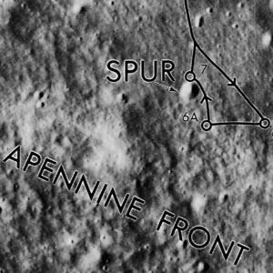
Apennine Front
Contents
Apennine Front (Apollo 15 site feature name and informal geologic name)
|
Lat: 25.9°N, Long: 3.7°E, Diameter: 6 km, Rükl: 22 |
Apollo 15 Site Traverses Chart
Images
LPOD Photo Gallery Lunar Orbiter Images Apollo Images
Maps
(LAC zone 41B4) LAC map Geologic map LM map LTO map Topophotomap Lunar Photomap (Site Traverse)
Description
Originally an informal name used by geologists to refer to the extensive Imbrium-facing side of the Apennine Mountains, a small portion of this later visited by Apollo 15 astronauts was labeled Apennine Front on Topophotomap 41B4S1 and on Site Traverse Map 41B4S4 and has become part of the IAU Nomenclature. In reading journal articles, it is often difficult to distinguish whether the authors are referring to the specific small area labeled on Topophotomap 41B4S1, to everything along the base of the Apennines near the Apollo 15 landing site, or to the "Apennine Front" in the broadest sense.

  This use on the map is at odds with all use in the lunar geologic literature. The Apennine Front is the scarp along the Mare Imbrium facing side of the Apennines. - tychocrater tychocrater May 23, 2009
Description: Wikipedia
The Apennine Front is described about halfway in the page Hadley-Apennine
Additional Information
- In the IAU sense, the Landing Site Name Apennine Front is a Minor Feature for which Topophotomap 41B4S1 is given as the reference. On that map, it marks the point where the slope of Mons Hadley Delta meets the plain of Palus Putredinis. Most of the Apollo 15 "Apennine Front" samples were actually collected in the vicinity of Spur, a 90 m diameter impact crater about 300 m from the base (~70 m higher in elevation). Site Traverse Map 41B4S4 places the Apennine Front label much higher up the slope, well above Spur crater, a little over 1 km from the location indicated on Topophotomap 41B4S1.
- The name also appears on a Map of informal astronaut-assigned landing site names posted in Eric Jones' Apollo 15 Image Library, but it does not appear to have been intended to refer to any specific feature.
- As indicated in the title line of this page, the IAU's Apennine Front has been assigned an official "diameter" of 6 km, although no specific boundaries are indicated on any of the maps cited above.
- Because the IAU's Planetary Gazetteer lists feature positions only to the nearest 0.1 degrees in lunar longitude and latitude, the officially listed coordinates of Apennine Front and Spur are identical (25.9 N/3.7 E), even though they are presumably distinct features. In the Apollo 15 control system, Spur crater is actually shown at 25.974 N/3.657 E. The center of the Apennine Front label is placed at 25.976 N/3.680 E (foot of Mons Hadley Delta slope) on Topophotomap 41B4S1, and at 25.957 N/3.643 E (well up the Mons Hadley Delta slope) on Site Traverse Map 41B4S4.
Nomenclature
- Apennine Front is listed in the IAU Planetary Gazetteer as an "astronaut-named feature, Apollo 15 site," approved in 1973. The list of approved names on which it appeared was not actually published until 1976
- In the geologist-named sense "Apennine Front" has a meaning similar to the Rocky Mountain Front on Earth. In the IAU-adopted sense, according to IAU Transactions XVIB, the official meaning is: "the explored foothills of Hadley Delta".
- The origin of the diameter of 6 km that currently appears in the IAU Planetary Gazetteer is unknown. - Jim Mosher
LPOD Articles
Bibliography
- Taylor, S. R. et al. 1973. Lunar highlands composition: Apennine Front. Proceedings of the Lunar Science Conference, vol. 4, p.1445
- Simon, S. B.; Papike, J. J.; Laul, J. C. 1988. Chemistry and petrology of the Apennine Front, Apollo 15. I - KREEP basalts and plutonic rocks. Lunar and Planetary Science Conference, 18th, Houston, TX, Mar. 16-20, 1987, Proceedings (A89-10851 01-91). Cambridge and New York/Houston, TX, Cambridge University Press/Lunar and Planetary Institute. p. 187-201.
- Ryder, G. 1989. Mare basalts on the Apennine Front and the mare stratigraphy of the Apollo 15 landing site. Lunar and Planetary Science Conference, 19th, Houston, TX, Mar. 14-18, 1988, Proceedings (A89-36486 15-91). Cambridge/Houston, TX, Cambridge University Press/Lunar and Planetary Institute. p. 43-50.
