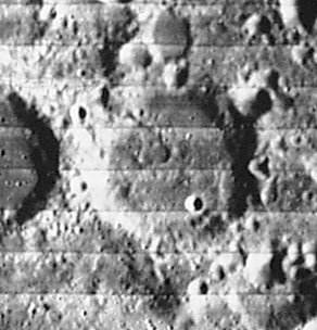
Büsching
Contents
Büsching
|
Lat: 38.0°S, Long: 20.0°E, Diam: 52 km, Depth: 1.81 km, Rükl: 66 |
Images
LPOD Photo Gallery Lunar Orbiter Images Apollo Images
Maps
(LAC zone 113A3) LAC map Geologic map
Description
Description: Elger
(IAU Directions) BUSCHING.--A ring-plain S. of Zagut, about 36 miles in diameter, with a moderately high but irregular wall. There are several craterlets within and some low hills.
Description: Wikipedia
Additional Information
Depth data from Kurt Fisher database
- Westfall, 2000: 1.81 km
- Viscardy, 1985: 1.7 km
- Cherrington, 1969: 2.4 km
- Satellite crater Busching E is on the ALPO list of banded craters
Nomenclature
Anton Friedrich Büsching (1724-1793) was a celebrated German geographer. His Erdbeschreibung ("Earth description") was the first geographical work of any scientific merit. It gives only the geography of Europe.
LPOD Articles
Bibliography
