Lorentz
Contents
- 1 Lorentz Basin - with Nernst and Rontgen on its floor
- 2 Table of Contents
- 2.1 Images
- 2.2 Four Lunar Orbiter IV photographs of the Lorentz-Nernst-Rontgen group, made just after local sunrise:
- 2.3 Maps
- 2.4 Basin Classification
- 2.5 Description
- 2.6 Description: Wikipedia
- 2.7 Additional Information
- 2.8 Nomenclature
- 2.9 LPOD Articles
- 2.10 Bibliography
- 2.11 Lorentz in the Sourcebook Project (William R. Corliss)
Lorentz Basin - with Nernst and Rontgen on its floor
(unofficial name; IAU crater name: Lorentz, 312 km diam)
| Lat: 32.6°N, Long: 95.3°W, Main ring diam: 365 km, Basin depth: 4.45 km, Rükl: (farside) |
Table of Contents
[#Lorentz Basin - with Nernst and Rontgen on its floor Lorentz Basin - with Nernst and Rontgen on its floor]
[#Lorentz Basin - with Nernst and Rontgen on its floor-Images Images]
[#Lorentz Basin - with Nernst and Rontgen on its floor-Four Lunar Orbiter IV photographs of the Lorentz-Nernst-Rontgen group, made just after local sunrise: Four Lunar Orbiter IV photographs of the Lorentz-Nernst-Rontgen group, made just after local sunrise:]
[#Lorentz Basin - with Nernst and Rontgen on its floor-Maps Maps]
[#Lorentz Basin - with Nernst and Rontgen on its floor-Basin Classification Basin Classification]
[#Lorentz Basin - with Nernst and Rontgen on its floor-Description Description]
[#Lorentz Basin - with Nernst and Rontgen on its floor-Description: Wikipedia Description: Wikipedia]
[#Lorentz Basin - with Nernst and Rontgen on its floor-Additional Information Additional Information]
[#Lorentz Basin - with Nernst and Rontgen on its floor-Nomenclature Nomenclature]
[#Lorentz Basin - with Nernst and Rontgen on its floor-LPOD Articles LPOD Articles]
[#Lorentz Basin - with Nernst and Rontgen on its floor-Bibliography Bibliography]
[#Lorentz Basin - with Nernst and Rontgen on its floor-Lorentz in the Sourcebook Project (William R. Corliss) Lorentz in the Sourcebook Project (William R. Corliss)]


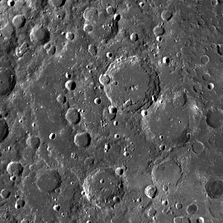
Upper image: LROC . The double ring structure is preserved only on western half of the basin; eastern sector dominated by the presence of Nernst and Röntgen craters, plus Laue on top of S rim.
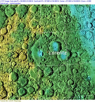
Lower image: Clementine, Clementine LIDAR Altimeter texture from PDS Map-a-Planet remapped to north-up aerial view by LTVT. The dot is the center position and the white circle the main ring position from Chuck Wood's Impact Basin Database. Grid spacing = 10 degrees.
Images
LPOD Photo Gallery Lunar Orbiter Images
Four Lunar Orbiter IV photographs of the Lorentz-Nernst-Rontgen group, made just after local sunrise:
- LO-IV-182-med, in which the Lorentz-Nernst-Rontgen group was captured at the upper half of the frame. The largest part of Lorentz is still in darkness. Craters Nernst and Rontgen are easily detectable (note the small central peak on the floor of Rontgen).
- LO-IV-187-med, in which the group was captured very near the frame's upper margin.
- LO-IV-188-med, in which the group was captured at the upper half of the frame (this is the best frame of the four).
- LO-IV-190-med, in which the group was captured at the lower-left section of the frame.
- Research Danny Caes
Maps
(LAC zone 36C4) USGS Digital Atlas PDF
Basin Classification
(description of terms and most numeric basin data from Wood, C.A. (2004) Impact Basin Database)
| Certainty of Existence |
USGS Age |
Wilhelms Age Group |
Ring Diameters |
Mare Thickness |
Mascon |
| Certain |
Pre-Nectarian |
6 |
170, 365 km |
0.9 km |
No; -33 mGal gravity anomaly |
Description
Description: Wikipedia
Additional Information
Nomenclature
The IAU crater name honors Hendrik Antoon Lorentz (1853-1928), a Dutch physicist and Nobel laureate.
- The impact basin is named after the crater.
LPOD Articles
Bibliography
Lorentz in the Sourcebook Project (William R. Corliss)
- In Mysterious Universe, a handbook of astronomical anomalies (1979) :
- Page 660: Motion of the Earth through the Ether (Science, 1925).
This page has been edited 1 times. The last modification was made by - tychocrater tychocrater on Jun 13, 2009 3:24 pm - afx3u2