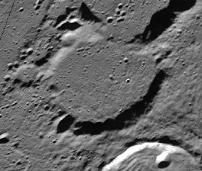
Challis
Contents
Challis
|
Lat: 79.58°N, Long: 9.09°E, Diam: 53.21 km, Depth: 1.73 km, Rükl: 4, Nectarian |
Table of Contents
[#Challis Challis]
[#Challis-Images Images]
[#Challis-Maps Maps]
[#Challis-Description Description]
[#Challis-Description-Elger Elger]
[#Challis-Description-Wikipedia Wikipedia]
[#Challis-Additional Information Additional Information]
[#Challis-Nomenclature Nomenclature]
[#Challis-LPOD Articles LPOD Articles]
[#Challis-Bibliography Bibliography]
[#Challis-James Challis in the Sourcebook Project (William R. Corliss) James Challis in the Sourcebook Project (William R. Corliss)]

Clementine
Images
LPOD Photo Gallery Lunar Orbiter Images
Maps
(LAC zone 3B2) USGS Digital Atlas PDF
Description
Elger
(IAU Directions) CHALLIS.--A ring-plain adjoining Scoresby on the N.W. It is of about the same size and shape.
Wikipedia
Additional Information
- IAU page: Challis
- Depth data from Kurt Fisher database
- Westfall, 2000: 1.73 km
- Cherrington, 1969: 2.8 km
Nomenclature
- Named for James Challis (December 12, 1803 – December 3, 1882), a British clergyman and astronomer. He was born in Braintree, Essex and died in Cambridge. He was director of the Cambridge Observatory at the University of Cambridge from 1836 until 1861, at which time he was succeeded by John Couch Adams.
LPOD Articles
Bibliography
James Challis in the Sourcebook Project (William R. Corliss)
- In Mysterious Universe, a handbook of astronomical anomalies (1979) :
- Page 495: Ring of Neptune (Astronomische Nachrichten, 1847).
- Page 496: Neptune, its supposed ring and satellite (American Journal of Science, 1847).
- Page 496: Reflections concerning Neptune's ring (William G. Hoyt, Sky and Telescope, 1978).
Named Features -- Prev: Chaffee -- Next: Chalonge
This page has been edited 1 times. The last modification was made by - tychocrater tychocrater on Jun 13, 2009 3:24 pm - afx3u3