Borel
Contents
Borel (in the southeastern part of Mare Serenitatis)
(formerly Le Monnier C)
|
Lat: 22.3°N, Long: 26.4°E, Diam: 4 km, Depth: 1.09 km, Rükl: 24 |
Table of Contents
[#Borel (in the southeastern part of Mare Serenitatis) Borel (in the southeastern part of Mare Serenitatis)]
[#Borel (in the southeastern part of Mare Serenitatis)-Images Images]
[#Borel (in the southeastern part of Mare Serenitatis)-Maps Maps]
[#Borel (in the southeastern part of Mare Serenitatis)-Description Description]
[#Borel (in the southeastern part of Mare Serenitatis)-Description: Wikipedia Description: Wikipedia]
[#Borel (in the southeastern part of Mare Serenitatis)-Additional Information Additional Information]
[#Borel (in the southeastern part of Mare Serenitatis)-Nomenclature Nomenclature]
[#Borel (in the southeastern part of Mare Serenitatis)-LPOD Articles LPOD Articles]
[#Borel (in the southeastern part of Mare Serenitatis)-Bibliography Bibliography]

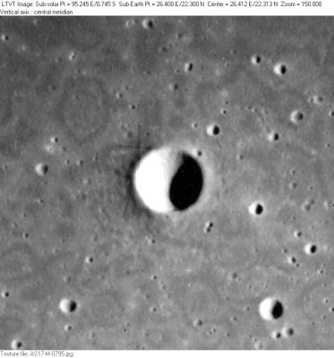
AS17-M-0795 Regarding the background mottles: a similar pattern appears on all the Apollo 17 Metric images of this region, but the details of the reticulation are different on every frame. The pattern is listed as a photographic defect on LTO-42C2 (see annotation in lower right corner).
Images
LPOD Photo Gallery Lunar Orbiter Images Apollo Images
- The bowl-shaped crater Borel was also captured on Apollo 15's orbital ITEK-panoramic frame AS15-P-9304 and its stereo-companion 9309. Borel is the largest one of the depicted craters.
- Post sunrise views of Borel were captured on Apollo 17's ITEK frames AS17-P-2319 and AS17-P-2326. On both frames, scroll to the right until you see the largest one of the small craters: that's Borel.
Additional research orbital Apollo 15 and Apollo 17 photography: Danny Caes
Maps
(LAC zone 42C2) LAC map Geologic map LM map LTO map
Description
Description: Wikipedia
Additional Information
Depth data from Kurt Fisher database
- Westfall, 2000: 1.09 km
- Viscardy, 1985: 0.95 km
- The shadow in AS17-M-0795 suggests a bowl-shaped form with a maximum depth of about 1060 m. - JimMosher JimMosher
- The WAC mosaic in the online LROC ACT-REACT QUICK MAP shows some sort of dark concentric band just below Borel's rim (all the way around on its inner slopes). - DannyCaes DannyCaes Aug 20, 2017
Nomenclature
Félix Édouard Émile; French mathematician (1871-1956).
- This replacement name for a formerly lettered crater was introduced on LTO-42C2. - JimMosher JimMosher
LPOD Articles
Bibliography
This page has been edited 1 times. The last modification was made by - tychocrater tychocrater on Jun 13, 2009 3:24 pm - afx3u2