Rima Mairan
Contents
Rima Mairan
| Lat: 38.0°N, Long: 47.0°W, Length: 90 km, Depth: km, Rükl: 9 |
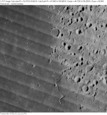
LO-IV-158H Rima Mairan extends vertically along the center of this image. The 10-km flooded crater at top center is not named, but several of the small ones in the field to the right are: Mairan C and F and Gruithuisen R and S. See the USGS-IAU Digital Atlas/Nomenclature Chart (PDF).
Images
LPOD Photo Gallery Lunar Orbiter Images Apollo Images
- Apollo 15's orbital B-and-W Hasselblad AS15-95-12870 doesn't show Rima Sharp (as mentioned in the caption), it shows a northward looking oblique view of Rima Mairan.
- The last frames of Apollo 15's color-Hasselblad magazine 93-P show Rima Mairan as seen from an orbital location slightly southward of it (looking "up north", toward the northern horizon). Of these, AS15-93-12733 shows Rima Mairan near the centre of the frame, with the curious volcanic hillock Mairan T near the upper margin.
- Research orbital Apollo 15 photography: Danny Caes.
Maps
(LAC zone 23C1) LAC map Geologic map
Description
Description: Wikipedia
Additional Information
Dark spot at 37°15' North/ 46°20' West, as part of Rima Mairan. This dark spot is visible on page 46 (LAC 23) in the Clementine Atlas of the Moon.- DannyCaes Sep 4, 2011
Nomenclature
- Named after the nearby crater. (Mairan)
- Number 85 in Debra Hurwitz's Atlas and Catalog of Sinuous Rilles (together with Rima Sharp).
- This feature was not depicted on the System of Lunar Craters Quad Maps, and it is depicted but not named on LAC-23. It is not known precisely when or where the present name was introduced (the IAU Planetary Gazetteer gives LAC-23 as the map reference), but it was approved "as assigned" by the IAU in 1985 (IAU Transactions XIXB).
LPOD Articles
Three Rilles and a Strange Volcano
Bibliography
