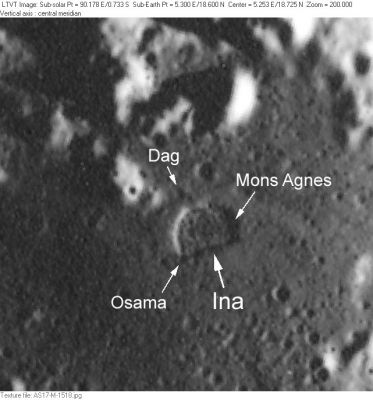
Dag
Contents
Dag (near the D-shaped Ina caldera in Lacus Felicitatis)
|
Lat: 18.7°N, Long: 5.3°E, Diam: 0.5 km, Depth: km, Rükl: 22 |
Table of Contents
[#Dag (near the D-shaped Ina caldera in Lacus Felicitatis) Dag (near the D-shaped Ina caldera in Lacus Felicitatis)]
[#Dag (near the D-shaped Ina caldera in Lacus Felicitatis)-Images Images]
[#Dag (near the D-shaped Ina caldera in Lacus Felicitatis)-Maps Maps]
[#Dag (near the D-shaped Ina caldera in Lacus Felicitatis)-Description Description]
[#Dag (near the D-shaped Ina caldera in Lacus Felicitatis)-Description: Wikipedia Description: Wikipedia]
[#Dag (near the D-shaped Ina caldera in Lacus Felicitatis)-Additional Information Additional Information]
[#Dag (near the D-shaped Ina caldera in Lacus Felicitatis)-Nomenclature Nomenclature]
[#Dag (near the D-shaped Ina caldera in Lacus Felicitatis)-LPOD Articles LPOD Articles]
[#Dag (near the D-shaped Ina caldera in Lacus Felicitatis)-Bibliography Bibliography]

AS17-M-1518 Dag is a very small depression a little beyond the north rim of the Ina caldera in Lacus Felicitatis. The other IAU-named features in this field are Osama and Mons Agnes.
Images
LPOD Photo Gallery Lunar Orbiter Images Apollo Images
Maps
(LAC zone 41C3) LAC map Geologic map LM map LTO map Topophotomap
Description
Description: Wikipedia
Additional Information
Nomenclature
- Scandinavian male name.
- According to NASA RP-1097, "Dag" is a Minor Feature whose name was originally intended only for use in connection with Topophotomap 41C3/S1(on which it is plotted).
LPOD Articles
See at page Ina
Bibliography
This page has been edited 1 times. The last modification was made by - tychocrater tychocrater on Jun 13, 2009 3:24 pm - afx3u2