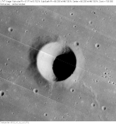
Dechen
Contents
Dechen
|
Lat: 46.1°N, Long: 68.2°W, Diam: 12 km, Depth: 2.29 km, Rükl: 8 |
Table of Contents
[#Dechen Dechen]
[#Dechen-Images Images]
[#Dechen-Maps Maps]
[#Dechen-Description Description]
[#Dechen-Description: Wikipedia Description: Wikipedia]
[#Dechen-Additional Information Additional Information]
[#Dechen-Nomenclature Nomenclature]
[#Dechen-LPOD Articles LPOD Articles]
[#Dechen-LROC Articles LROC Articles]
[#Dechen-Bibliography Bibliography]

LO-IV-183H
Images
LPOD Photo Gallery Lunar Orbiter Images Apollo Images
Maps
(LAC zone 22B1) USGS Digital Atlas PDF
Description
Description: Wikipedia
Additional Information
- Depth data from Kurt Fisher database
- Westfall, 2000: 2.29 km
- From the shadows in LO-IV-183H, Dechen is 2300-2500 m deep. - JimMosher JimMosher
- Dechen's peculiar appearance when the morning terminator runs over it (looking like some sort of "flat dish"), was photographed by the dedicated lunar observer Stefan Lammel. - DannyCaes DannyCaes Dec 8, 2007
- TSI = 5, CPI = 5, FI = 5; MI =15 Smith and Sanchez, 1973
Nomenclature
- Ernst Heinrich Karl von; German geologist, mineralogist (1800-1889).
- According to Whitaker (p. 224), this name was introduced by Schmidt.
LPOD Articles
LROC Articles
Small crater in Oceanus Procellarum (northeast of Dechen D).
Bibliography
This page has been edited 1 times. The last modification was made by - tychocrater tychocrater on Jun 13, 2009 3:24 pm - afx3u2