Difference between revisions of "Lindenau"
| Line 3: | Line 3: | ||
{| class="wiki_table" | {| class="wiki_table" | ||
| | | | ||
| − | Lat: 32.3°S, Long: 24.9°E, Diam: 53 km, Depth: 2.93 km, Rükl: 67, [ | + | Lat: 32.3°S, Long: 24.9°E, Diam: 53 km, Depth: 2.93 km, Rükl: 67, [[Stratigraphy|Upper Imbrian]]<br /> |
|} | |} | ||
<div id="toc"> | <div id="toc"> | ||
| Line 11: | Line 11: | ||
[http://www.lpod.org/coppermine/thumbnails.php?album=search&type=full&search=Lindenau LPOD Photo Gallery] [http://www.lpi.usra.edu/resources/lunar_orbiter/bin/srch_nam.shtml?Lindenau%7C0 Lunar Orbiter Images] [http://www.lpi.usra.edu/resources/apollo/search/feature/?feature=Lindenau Apollo Images]<br /> <br /> | [http://www.lpod.org/coppermine/thumbnails.php?album=search&type=full&search=Lindenau LPOD Photo Gallery] [http://www.lpi.usra.edu/resources/lunar_orbiter/bin/srch_nam.shtml?Lindenau%7C0 Lunar Orbiter Images] [http://www.lpi.usra.edu/resources/apollo/search/feature/?feature=Lindenau Apollo Images]<br /> <br /> | ||
==Maps== | ==Maps== | ||
| − | ''([ | + | ''([[LAC%20zone|LAC zone]] 113B1)'' [http://www.lpi.usra.edu/resources/mapcatalog/LAC/lac113/ LAC map] [http://www.lpi.usra.edu/resources/mapcatalog/usgs/I695/ Geologic map]<br /> <br /> |
==Description== | ==Description== | ||
<br /> | <br /> | ||
==Description: Elger== | ==Description: Elger== | ||
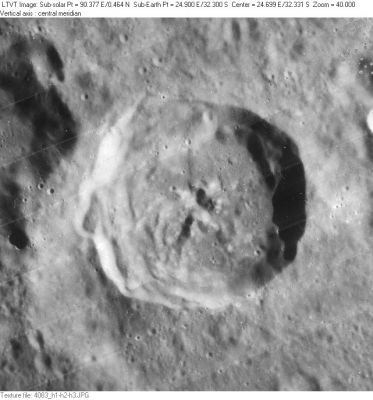
| − | ''([ | + | ''([[IAU%20Directions|IAU Directions]])'' LINDENAU.--This formation, about 35 miles in diameter, is bounded on the E. by a regular unbroken wall nearly 8,600 feet in height; but which on the W. and N.W. is far loftier and more complex, rising to about 12,000 feet above the floor, consisting of four or more distinct ramparts, separated by deep valleys, and extending towards [[Rabbi%20Levi|Rabbi Levi]]. Neison points out that under a high light Lindenau appears to have a bright uniform single wall. There is a small central mountain and some minor inequalities in the interior.<br /> <br /> |
==Description: Wikipedia== | ==Description: Wikipedia== | ||
[http://en.wikipedia.org/wiki/Lindenau_(crater) Lindenau]<br /> <br /> | [http://en.wikipedia.org/wiki/Lindenau_(crater) Lindenau]<br /> <br /> | ||
==Additional Information== | ==Additional Information== | ||
| − | * Depth data from [ | + | * Depth data from [[Kurt%20Fisher%20crater%20depths|Kurt Fisher database]] |
** Arthur, 1974: 2.93 km | ** Arthur, 1974: 2.93 km | ||
** Westfall, 2000: 2.93 km | ** Westfall, 2000: 2.93 km | ||
| Line 25: | Line 25: | ||
** Cherrington, 1969: 2.71 km | ** Cherrington, 1969: 2.71 km | ||
* From the shadows in LO-IV-083H, the east rim of '''Lindenau''' is at least 2900 m above the floor. <span class="membersnap">- [http://www.wikispaces.com/user/view/JimMosher [[Image:JimMosher-lg.jpg|16px|JimMosher]]] [http://www.wikispaces.com/user/view/JimMosher JimMosher]</span> | * From the shadows in LO-IV-083H, the east rim of '''Lindenau''' is at least 2900 m above the floor. <span class="membersnap">- [http://www.wikispaces.com/user/view/JimMosher [[Image:JimMosher-lg.jpg|16px|JimMosher]]] [http://www.wikispaces.com/user/view/JimMosher JimMosher]</span> | ||
| − | * [ | + | * [[Central%20peak%20composition|Central peak composition]]: A, GNTA1 & GNTA2 ([[Tompkins%20%26%20Pieters%2C%201999|Tompkins & Pieters, 1999]]) |
<br /> | <br /> | ||
==Nomenclature== | ==Nomenclature== | ||
Bernhard von; German astronomer (1780-1854).<br /> | Bernhard von; German astronomer (1780-1854).<br /> | ||
| − | * According to ''[ | + | * According to ''[[Whitaker|Whitaker]]'' (p. 219), this name was introduced by [[M%C3%A4dler|Mädler]]. |
<br /> | <br /> | ||
==LPOD Articles== | ==LPOD Articles== | ||
Revision as of 15:01, 15 April 2018
Contents
Lindenau
|
Lat: 32.3°S, Long: 24.9°E, Diam: 53 km, Depth: 2.93 km, Rükl: 67, Upper Imbrian |
Table of Contents
[#Lindenau Lindenau]
[#Lindenau-Images Images]
[#Lindenau-Maps Maps]
[#Lindenau-Description Description]
[#Lindenau-Description: Elger Description: Elger]
[#Lindenau-Description: Wikipedia Description: Wikipedia]
[#Lindenau-Additional Information Additional Information]
[#Lindenau-Nomenclature Nomenclature]
[#Lindenau-LPOD Articles LPOD Articles]
[#Lindenau-Bibliography Bibliography]

LO-IV-083H
Images
LPOD Photo Gallery Lunar Orbiter Images Apollo Images
Maps
(LAC zone 113B1) LAC map Geologic map
Description
Description: Elger
(IAU Directions) LINDENAU.--This formation, about 35 miles in diameter, is bounded on the E. by a regular unbroken wall nearly 8,600 feet in height; but which on the W. and N.W. is far loftier and more complex, rising to about 12,000 feet above the floor, consisting of four or more distinct ramparts, separated by deep valleys, and extending towards Rabbi Levi. Neison points out that under a high light Lindenau appears to have a bright uniform single wall. There is a small central mountain and some minor inequalities in the interior.
Description: Wikipedia
Additional Information
- Depth data from Kurt Fisher database
- Arthur, 1974: 2.93 km
- Westfall, 2000: 2.93 km
- Viscardy, 1985: 2.9 km
- Cherrington, 1969: 2.71 km
- From the shadows in LO-IV-083H, the east rim of Lindenau is at least 2900 m above the floor. - JimMosher JimMosher
- Central peak composition: A, GNTA1 & GNTA2 (Tompkins & Pieters, 1999)
Nomenclature
Bernhard von; German astronomer (1780-1854).
LPOD Articles
Bibliography
This page has been edited 1 times. The last modification was made by - tychocrater tychocrater on Jun 13, 2009 3:24 pm - afx3u2