Difference between revisions of "Doerfel"
(Created page with "<div id="content_view" class="wiki" style="display: block"> =Doerfel= {| class="wiki_table" | Lat: 69.1°S, Long: 107.9°W, Diam: 68 km, Depth: km, Rükl: ''(farside)'', [...") |
|||
| Line 3: | Line 3: | ||
{| class="wiki_table" | {| class="wiki_table" | ||
| | | | ||
| − | Lat: 69.1°S, Long: 107.9°W, Diam: 68 km, Depth: km, Rükl: ''(farside)'', [ | + | Lat: 69.1°S, Long: 107.9°W, Diam: 68 km, Depth: km, Rükl: ''(farside)'', [[Stratigraphy|Upper Imbrian]]<br /> |
|- | |- | ||
| | | | ||
| Line 10: | Line 10: | ||
[[Image:doerfel-color.jpg|doerfel-color.jpg]]<br /> | [[Image:doerfel-color.jpg|doerfel-color.jpg]]<br /> | ||
|} | |} | ||
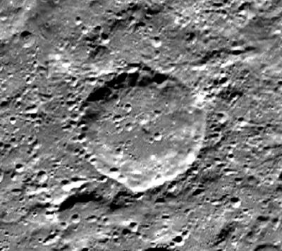
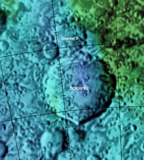
| − | '''Left:''' [http://www.mapaplanet.org/explorer-bin/explorer.cgi?map=Moon&layers=moon_clementine_base_v2&info=NO&advoption=NO&sizeSelector=imageSize&lines=720&samples=1440&Resolution=20&r=1&g=1&b=1&projection=SIMP&grid=none&stretch=auto&north=-79.25&south=-61.25&west=235.25&east=271.25¢er_lat=0¢er=253.25&defaultcenter=on Clementine] image from [http://www.mapaplanet.org Map-A-Planet]. '''Right:''' [http://planetarynames.wr.usgs.gov/images/Lunar/lac_143.pdf Color-coded topography LAC 143] image from [ | + | '''Left:''' [http://www.mapaplanet.org/explorer-bin/explorer.cgi?map=Moon&layers=moon_clementine_base_v2&info=NO&advoption=NO&sizeSelector=imageSize&lines=720&samples=1440&Resolution=20&r=1&g=1&b=1&projection=SIMP&grid=none&stretch=auto&north=-79.25&south=-61.25&west=235.25&east=271.25¢er_lat=0¢er=253.25&defaultcenter=on Clementine] image from [http://www.mapaplanet.org Map-A-Planet]. '''Right:''' [http://planetarynames.wr.usgs.gov/images/Lunar/lac_143.pdf Color-coded topography LAC 143] image from [[USGS%20Digital%20Atlas|USGS Digital Atlas]].<div id="toc"> |
=Table of Contents= | =Table of Contents= | ||
<div style="margin-left: 1em">[#Doerfel Doerfel]</div><div style="margin-left: 2em">[#Doerfel-Images Images]</div><div style="margin-left: 2em">[#Doerfel-Maps Maps]</div><div style="margin-left: 2em">[#Doerfel-Description Description]</div><div style="margin-left: 2em">[#Doerfel-Description: Wikipedia Description: Wikipedia]</div><div style="margin-left: 2em">[#Doerfel-Additional Information Additional Information]</div><div style="margin-left: 2em">[#Doerfel-Nomenclature Nomenclature]</div><div style="margin-left: 2em">[#Doerfel-LPOD Articles LPOD Articles]</div><div style="margin-left: 2em">[#Doerfel-Bibliography Bibliography]</div></div><br /> <br /> <br /> | <div style="margin-left: 1em">[#Doerfel Doerfel]</div><div style="margin-left: 2em">[#Doerfel-Images Images]</div><div style="margin-left: 2em">[#Doerfel-Maps Maps]</div><div style="margin-left: 2em">[#Doerfel-Description Description]</div><div style="margin-left: 2em">[#Doerfel-Description: Wikipedia Description: Wikipedia]</div><div style="margin-left: 2em">[#Doerfel-Additional Information Additional Information]</div><div style="margin-left: 2em">[#Doerfel-Nomenclature Nomenclature]</div><div style="margin-left: 2em">[#Doerfel-LPOD Articles LPOD Articles]</div><div style="margin-left: 2em">[#Doerfel-Bibliography Bibliography]</div></div><br /> <br /> <br /> | ||
| Line 16: | Line 16: | ||
[http://www.lpod.org/coppermine/thumbnails.php?album=search&type=full&search=Doerfel LPOD Photo Gallery] [http://www.lpi.usra.edu/resources/lunar_orbiter/bin/srch_nam.shtml?Doerfel%7C0 Lunar Orbiter Images]<br /> <br /> | [http://www.lpod.org/coppermine/thumbnails.php?album=search&type=full&search=Doerfel LPOD Photo Gallery] [http://www.lpi.usra.edu/resources/lunar_orbiter/bin/srch_nam.shtml?Doerfel%7C0 Lunar Orbiter Images]<br /> <br /> | ||
==Maps== | ==Maps== | ||
| − | ''([ | + | ''([[LAC%20zone|LAC zone]] 143A3)'' [http://planetarynames.wr.usgs.gov/images/Lunar/lac_143.pdf USGS Digital Atlas PDF]<br /> <br /> |
==Description== | ==Description== | ||
<br /> | <br /> | ||
| Line 25: | Line 25: | ||
==Nomenclature== | ==Nomenclature== | ||
* Named for Georg Samuel Doerfel, a German astronomer (1643-1688). | * Named for Georg Samuel Doerfel, a German astronomer (1643-1688). | ||
| − | * The name [ | + | * The name [[Montes%20Doerfel|Montes Doerfel]], for some peaks seen at the [[limb|limb]], was given by [[Johann%20Schr%C3%B6ter|Johann Schröter]] and adopted by the [[IAU|IAU]]. Although later [[lunar%20mons|discontinued]] it was printed on some of the modern moon maps. The crater '''Doerfel''' is in the same general area. |
<br /> | <br /> | ||
==LPOD Articles== | ==LPOD Articles== | ||
<br /> | <br /> | ||
==Bibliography== | ==Bibliography== | ||
| − | Hill, Harold - ''[ | + | Hill, Harold - ''[[A%20Portfolio%20of%20Lunar%20Drawings|A Portfolio of Lunar Drawings]]'', Cambridge 1991, pages 130-131 ([[Bailly|Bailly]] and [[Montes%20Doerfel|the Doerfels]]).<br /> <br /> |
---- | ---- | ||
This page has been edited 1 times. The last modification was made by <span class="membersnap">- [http://www.wikispaces.com/user/view/tychocrater [[Image:tychocrater-lg.jpg|16px|tychocrater]]] [http://www.wikispaces.com/user/view/tychocrater tychocrater]</span> on Jun 13, 2009 3:24 pm - ''afx3u2''</div> | This page has been edited 1 times. The last modification was made by <span class="membersnap">- [http://www.wikispaces.com/user/view/tychocrater [[Image:tychocrater-lg.jpg|16px|tychocrater]]] [http://www.wikispaces.com/user/view/tychocrater tychocrater]</span> on Jun 13, 2009 3:24 pm - ''afx3u2''</div> | ||
Revision as of 14:46, 15 April 2018
Contents
Doerfel
|
Lat: 69.1°S, Long: 107.9°W, Diam: 68 km, Depth: km, Rükl: (farside), Upper Imbrian | |
Table of Contents
[#Doerfel Doerfel]
[#Doerfel-Images Images]
[#Doerfel-Maps Maps]
[#Doerfel-Description Description]
[#Doerfel-Description: Wikipedia Description: Wikipedia]
[#Doerfel-Additional Information Additional Information]
[#Doerfel-Nomenclature Nomenclature]
[#Doerfel-LPOD Articles LPOD Articles]
[#Doerfel-Bibliography Bibliography]
Images
LPOD Photo Gallery Lunar Orbiter Images
Maps
(LAC zone 143A3) USGS Digital Atlas PDF
Description
Description: Wikipedia
Additional Information
Nomenclature
- Named for Georg Samuel Doerfel, a German astronomer (1643-1688).
- The name Montes Doerfel, for some peaks seen at the limb, was given by Johann Schröter and adopted by the IAU. Although later discontinued it was printed on some of the modern moon maps. The crater Doerfel is in the same general area.
LPOD Articles
Bibliography
Hill, Harold - A Portfolio of Lunar Drawings, Cambridge 1991, pages 130-131 (Bailly and the Doerfels).
This page has been edited 1 times. The last modification was made by - tychocrater tychocrater on Jun 13, 2009 3:24 pm - afx3u2

