Difference between revisions of "Zupus"
(Created page with "<div id="content_view" class="wiki" style="display: block"> =Zupus= {| class="wiki_table" | Lat: 17.2°S, Long: 52.3°W, Diam: 38 km, Depth: 1.01 km, [http://the-moon.wiki...") |
|||
| Line 3: | Line 3: | ||
{| class="wiki_table" | {| class="wiki_table" | ||
| | | | ||
| − | Lat: 17.2°S, Long: 52.3°W, Diam: 38 km, Depth: 1.01 km, [http://the-moon. | + | Lat: 17.2°S, Long: 52.3°W, Diam: 38 km, Depth: 1.01 km, [http://the-moon.us/wiki/R%C3%BCkl%2051 Rükl: 51]<br /> |
|} | |} | ||
<div id="toc"> | <div id="toc"> | ||
| Line 11: | Line 11: | ||
[http://www.lpod.org/coppermine/thumbnails.php?album=search&type=full&search=Zupus LPOD Photo Gallery] [http://www.lpi.usra.edu/resources/lunar_orbiter/bin/srch_nam.shtml?Zupus%7C0 Lunar Orbiter Images] [http://www.lpi.usra.edu/resources/apollo/search/feature/?feature=Zupus Apollo Images]<br /> <br /> | [http://www.lpod.org/coppermine/thumbnails.php?album=search&type=full&search=Zupus LPOD Photo Gallery] [http://www.lpi.usra.edu/resources/lunar_orbiter/bin/srch_nam.shtml?Zupus%7C0 Lunar Orbiter Images] [http://www.lpi.usra.edu/resources/apollo/search/feature/?feature=Zupus Apollo Images]<br /> <br /> | ||
==Maps== | ==Maps== | ||
| − | ''([http://the-moon. | + | ''([http://the-moon.us/wiki/LAC%20zone LAC zone] 92B2)'' [http://www.lpi.usra.edu/resources/mapcatalog/LAC/lac92/ LAC map] [http://www.lpi.usra.edu/resources/mapcatalog/usgs/I755/ Geologic map]<br /> <br /> |
==Description== | ==Description== | ||
<br /> | <br /> | ||
==Description: Elger== | ==Description: Elger== | ||
| − | ''([http://the-moon. | + | ''([http://the-moon.us/wiki/IAU%20Directions IAU Directions])'' ZUPUS.--A formation about 12 miles in diameter with a dark floor, situated in the hilly region N.W. of [http://the-moon.us/wiki/Mersenius Mersenius].<br /> <br /> |
==Description: Wikipedia== | ==Description: Wikipedia== | ||
[http://en.wikipedia.org/wiki/Zupus_(crater) Zupus]<br /> <br /> | [http://en.wikipedia.org/wiki/Zupus_(crater) Zupus]<br /> <br /> | ||
==Additional Information== | ==Additional Information== | ||
| − | Depth data from [http://the-moon. | + | Depth data from [http://the-moon.us/wiki/Kurt%20Fisher%20crater%20depths Kurt Fisher database]<br /> |
* Westfall, 2000: 1.01 km | * Westfall, 2000: 1.01 km | ||
* Cherrington, 1969: 1.34 km | * Cherrington, 1969: 1.34 km | ||
Revision as of 19:35, 11 April 2018
Contents
Zupus
|
Lat: 17.2°S, Long: 52.3°W, Diam: 38 km, Depth: 1.01 km, Rükl: 51 |
Table of Contents
[#Zupus Zupus]
[#Zupus-Images Images]
[#Zupus-Maps Maps]
[#Zupus-Description Description]
[#Zupus-Description: Elger Description: Elger]
[#Zupus-Description: Wikipedia Description: Wikipedia]
[#Zupus-Additional Information Additional Information]
[#Zupus-Nomenclature Nomenclature]
[#Zupus-LPOD Articles LPOD Articles]
[#Zupus-Bibliography Bibliography]

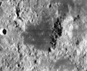
Lunar Orbiter IV 156-H2 submitted by Paolo Amoroso.
Note the pronounced mountain on the eastern part of Zupus's rim. Perhaps we could call it Mount Zupus.
Images
LPOD Photo Gallery Lunar Orbiter Images Apollo Images
Maps
(LAC zone 92B2) LAC map Geologic map
Description
Description: Elger
(IAU Directions) ZUPUS.--A formation about 12 miles in diameter with a dark floor, situated in the hilly region N.W. of Mersenius.
Description: Wikipedia
Additional Information
Depth data from Kurt Fisher database
- Westfall, 2000: 1.01 km
- Cherrington, 1969: 1.34 km
The eastern part of Zupus's floor shows some sort of layered appearance. This appearance is only detectable on the WAC - Big Shadows representation in the online LROC Quickmap.
Nomenclature
- Giovanni Battista Zupi (Zupus) (circa 1590–1650) was an Italian astronomer and mathematician. In 1639, Giovanni was the first person to discover that the planet Mercury had orbital phases, just like the Moon and Venus. His observations demonstrated that the planet orbited around the Sun. This occurred just 30 years after Galileo's first telescope design, and Giovanni's was only slightly more powerful.
- Zupus is one of Giovanni Baptista Riccioli's names, see page 215 of Ewen A. Whitaker's book Mapping and Naming the Moon (Appendix G).
- The dark spot which was called Zupus by Riccioli might have been the southern part of Michel Florent Van Langren's Flumen S. Augustini, this according to Van Langren's map on page 41 of Ewen A. Whitaker's book Mapping and Naming the Moon. The Strasbourg forgery of Van Langren's map (page 43) also shows the name Flumen S. Augustini. See also page 197 (Appendix D: Van Langren's nomenclature).- DannyCaes DannyCaes Jun 4, 2013
- Could we give the mountain at the eastern rim of Zupus a name? Perhaps Zupus Alpha? Or Mons Zupus? Mount Zupus?
LPOD Articles
ZUPIDDY DO DA, Still a Little Zupid
Bibliography
This page has been edited 1 times. The last modification was made by - tychocrater tychocrater on Jun 13, 2009 3:24 pm - afx3u2