Difference between revisions of "Rima Delisle"
| Line 6: | Line 6: | ||
|} | |} | ||
<div id="toc"> | <div id="toc"> | ||
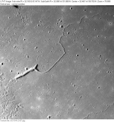
| − | + | [http://www.lpod.org/coppermine/albums/userpics/Rima-Delisle_AS15-M-2187_LTVT.JPG [[Image:normal_Rima-Delisle_AS15-M-2187_LTVT.JPG|external image normal_Rima-Delisle_AS15-M-2187_LTVT.JPG]]]<br /> ''[http://lpod.org/coppermine/displayimage.php?pos=-2805 AS15-M-2187]'' '''Rima Delisle''' is the main rille in this Apollo 15 Metric Camera view. A very small piece of the much longer [[Rima%20Diophantus|Rima Diophantus]] can be seen in the extreme lower right corner. At the middle of the left margin one can see the 1-km circular crater [[Linda|Linda]], named for no obvious region other than it caught the fancy of someone preparing a [[Topophotomap|Topophotomap]] of the region.<br /> <br /> | |
| − | |||
==Images== | ==Images== | ||
| − | [http://www.lpod.org/coppermine/thumbnails.php?album=search&type=full&search=Rima%20Delisle LPOD Photo Gallery] [http://www.lpi.usra.edu/resources/lunar_orbiter/bin/srch_nam.shtml?Rima%20Delisle%7C0 Lunar Orbiter Images] [http://www.lpi.usra.edu/resources/apollo/search/feature/?feature=Rima%20Delisle Apollo Images] Strange as it is, the LPI's search shows no match for '''Rima Delisle''', although there are several orbital photographs of it, made during the mission of Apollo 15!<span class="membersnap">- | + | [http://www.lpod.org/coppermine/thumbnails.php?album=search&type=full&search=Rima%20Delisle LPOD Photo Gallery] [http://www.lpi.usra.edu/resources/lunar_orbiter/bin/srch_nam.shtml?Rima%20Delisle%7C0 Lunar Orbiter Images] [http://www.lpi.usra.edu/resources/apollo/search/feature/?feature=Rima%20Delisle Apollo Images] Strange as it is, the LPI's search shows no match for '''Rima Delisle''', although there are several orbital photographs of it, made during the mission of Apollo 15!<span class="membersnap">- DannyCaes <small>Jan 24, 2010</small></span><br /> <br /> |
==Maps== | ==Maps== | ||
''([[LAC%20zone|LAC zone]] 39B2)'' [http://www.lpi.usra.edu/resources/mapcatalog/LAC/lac39/ LAC map] [http://www.lpi.usra.edu/resources/mapcatalog/usgs/I465/ Geologic map] [http://www.lpi.usra.edu/resources/mapcatalog/LM/lm39/ LM map] [http://www.lpi.usra.edu/resources/mapcatalog/LTO/lto39b2_1/ LTO map]<br /> <br /> | ''([[LAC%20zone|LAC zone]] 39B2)'' [http://www.lpi.usra.edu/resources/mapcatalog/LAC/lac39/ LAC map] [http://www.lpi.usra.edu/resources/mapcatalog/usgs/I465/ Geologic map] [http://www.lpi.usra.edu/resources/mapcatalog/LM/lm39/ LM map] [http://www.lpi.usra.edu/resources/mapcatalog/LTO/lto39b2_1/ LTO map]<br /> <br /> | ||
| Line 25: | Line 24: | ||
The ''dogbone''-shaped depression at Rima Delisle:<br /> ''GEOLOGIE AUF DEM MOND'' (J.E.Guest/ R.Greeley), seite 24, abbildung 2.4. C.<br /> <br /> | The ''dogbone''-shaped depression at Rima Delisle:<br /> ''GEOLOGIE AUF DEM MOND'' (J.E.Guest/ R.Greeley), seite 24, abbildung 2.4. C.<br /> <br /> | ||
---- | ---- | ||
| − | + | </div> | |
Revision as of 16:45, 15 April 2018
Contents
Rima Delisle (aka Rima Verdi)
|
Lat: 31.0°N, Long: 32.0°W, Length: 60 km, Depth: km, Rükl: 10 |
AS15-M-2187 Rima Delisle is the main rille in this Apollo 15 Metric Camera view. A very small piece of the much longer Rima Diophantus can be seen in the extreme lower right corner. At the middle of the left margin one can see the 1-km circular crater Linda, named for no obvious region other than it caught the fancy of someone preparing a Topophotomap of the region.
Images
LPOD Photo Gallery Lunar Orbiter Images Apollo Images Strange as it is, the LPI's search shows no match for Rima Delisle, although there are several orbital photographs of it, made during the mission of Apollo 15!- DannyCaes Jan 24, 2010
Maps
(LAC zone 39B2) LAC map Geologic map LM map LTO map
Description
Description: Wikipedia
Additional Information
Adjacent to Rima Delisle, near Rupes Boris, is a curious dogbone-shaped depression. This "dogbone" was photographed during the mission of Apollo 15, on black-and-white Hasselblad film. AS15-92-12458 shows both Rima Delisle (left) and the "dogbone" near centre. Another Hasselblad of it is AS15-81-10981 ("dogbone" near centre, Rima Delisle toward the top). Research: Danny Caes
Nomenclature
- Named from nearby crater Delisle
  - Number 115 in Debra Hurwitz's Atlas and Catalog of Sinuous Rilles.
  - The "Dogbone" shaped western end of Rima Delisle is also nicknamed "Butterfly Nut" or "Winged Nut" by Danny Caes
  - Rima Delisle was once called Rima Verdi on Lunar Topographic Orthophotomap 39-B2.
LPOD Articles
Bibliography
The dogbone-shaped depression at Rima Delisle:
 GEOLOGIE AUF DEM MOND (J.E.Guest/ R.Greeley), seite 24, abbildung 2.4. C.
