Difference between revisions of "Dorsum Scilla"
| Line 6: | Line 6: | ||
|} | |} | ||
<div id="toc"> | <div id="toc"> | ||
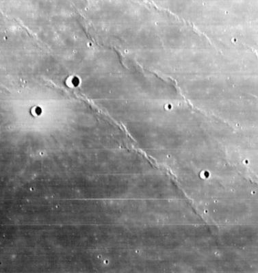
| − | + | [http://www.lpod.org/coppermine/displayimage.php?pid=1811&fullsize=1 [[Image:normal_Dorsum_Scilla_LO_iv_163_h1.jpg|external image normal_Dorsum_Scilla_LO_iv_163_h1.jpg]]]<br /> ''[http://lpod.org/coppermine/displayimage.php?pos=-1811 LOIV 163 H1]'' '''Dorsum Scilla''' is the southernmost of the three prominent ridges visible in this image (running up from the lower right corner). The crater with the bright halo is '''[[Lichtenberg|Lichtenberg]] B''', and its slightly larger companion to the northeast is '''[[Naumann|Naumann]] G'''. Depending on what map one consults, '''Dorsum Scilla''' either terminates at Naumann G, or continues on beyond the upper left corner of the present image, possibly terminating at [[Naumann|Naumann]] (~ 100 km away, and out of image off to the northwest). The two equally prominent ridges, seen in image to the northeast of '''Dorsum Scilla''', are unnamed.<br /> <br /> | |
| − | |||
==Images== | ==Images== | ||
[http://www.lpod.org/coppermine/thumbnails.php?album=search&type=full&search=Dorsum%20Scilla LPOD Photo Gallery] [http://www.lpi.usra.edu/resources/lunar_orbiter/bin/srch_nam.shtml?Dorsum%20Scilla%7C0 Lunar Orbiter Images]<br /> <br /> | [http://www.lpod.org/coppermine/thumbnails.php?album=search&type=full&search=Dorsum%20Scilla LPOD Photo Gallery] [http://www.lpi.usra.edu/resources/lunar_orbiter/bin/srch_nam.shtml?Dorsum%20Scilla%7C0 Lunar Orbiter Images]<br /> <br /> | ||
| Line 22: | Line 21: | ||
* Named for [http://en.wikipedia.org/wiki/Agostino_Scilla Agostino Scilla] (August 10, 1629 - May 31, 1700), an Italian painter, paleontologist, geologist, and pioneer in the study of fossils. He began to study fossils found in the hills of Sicily. In this work he argues for a scientific explanation for fossils, as opposed to them being of fantastic origin or a test of faith from God. He also correctly identified the supposedly magical objects that were called glossopetrae, or "tongue stones", as the teeth of sharks. | * Named for [http://en.wikipedia.org/wiki/Agostino_Scilla Agostino Scilla] (August 10, 1629 - May 31, 1700), an Italian painter, paleontologist, geologist, and pioneer in the study of fossils. He began to study fossils found in the hills of Sicily. In this work he argues for a scientific explanation for fossils, as opposed to them being of fantastic origin or a test of faith from God. He also correctly identified the supposedly magical objects that were called glossopetrae, or "tongue stones", as the teeth of sharks. | ||
| − | * '''Dorsum Scilla''' was among 120 names approved by the [[IAU|IAU]] in 1976 "as assigned" on the NASA [[LTO|LTO]] charts ([[IAU%20Transactions%20XVIB|IAU Transactions XVIB]]). However only the southernmost 14 km of it was actually charted on [http://www.lpi.usra.edu/resources/mapcatalog/LTO/lto38b1_2/ LTO-38B1]. The name seems to have been extended northward on [http://www.lpi.usra.edu/resources/mapcatalog/LM/lm38/ LM-38], and even further to the north on [http://planetarynames.wr.usgs.gov/images/Lunar/lac_38.pdf LAC-38] (540 kb PDF) of the [[USGS%20Digital%20Atlas|USGS Digital Atlas]]. With these extensions it would seem to have become a "dorsa" (a ridge system) rather than a "dorsum" (a single ridge). <span class="membersnap">- | + | * '''Dorsum Scilla''' was among 120 names approved by the [[IAU|IAU]] in 1976 "as assigned" on the NASA [[LTO|LTO]] charts ([[IAU%20Transactions%20XVIB|IAU Transactions XVIB]]). However only the southernmost 14 km of it was actually charted on [http://www.lpi.usra.edu/resources/mapcatalog/LTO/lto38b1_2/ LTO-38B1]. The name seems to have been extended northward on [http://www.lpi.usra.edu/resources/mapcatalog/LM/lm38/ LM-38], and even further to the north on [http://planetarynames.wr.usgs.gov/images/Lunar/lac_38.pdf LAC-38] (540 kb PDF) of the [[USGS%20Digital%20Atlas|USGS Digital Atlas]]. With these extensions it would seem to have become a "dorsa" (a ridge system) rather than a "dorsum" (a single ridge). <span class="membersnap">- Jim Mosher</span> |
<br /> | <br /> | ||
==LPOD Articles== | ==LPOD Articles== | ||
| Line 29: | Line 28: | ||
<br /> <br /> | <br /> <br /> | ||
---- | ---- | ||
| − | + | </div> | |
Revision as of 16:20, 15 April 2018
Contents
Dorsum Scilla
|
Lat: 32.8°N, Long: 60.4°W, Length: 108 km, Height: km, Rükl: 8 |

LOIV 163 H1 Dorsum Scilla is the southernmost of the three prominent ridges visible in this image (running up from the lower right corner). The crater with the bright halo is Lichtenberg B, and its slightly larger companion to the northeast is Naumann G. Depending on what map one consults, Dorsum Scilla either terminates at Naumann G, or continues on beyond the upper left corner of the present image, possibly terminating at Naumann (~ 100 km away, and out of image off to the northwest). The two equally prominent ridges, seen in image to the northeast of Dorsum Scilla, are unnamed.
Images
LPOD Photo Gallery Lunar Orbiter Images
Maps
(LAC zone 23D4) LAC map Geologic map
Description
Description: Wikipedia
Additional Information
- The position and diameter given in the title line are the current values in the IAU Planetary Gazetteer. Most definitions seem to extend Dorsum Scilla farther to the north (see Nomenclature).
Nomenclature
- Named for Agostino Scilla (August 10, 1629 - May 31, 1700), an Italian painter, paleontologist, geologist, and pioneer in the study of fossils. He began to study fossils found in the hills of Sicily. In this work he argues for a scientific explanation for fossils, as opposed to them being of fantastic origin or a test of faith from God. He also correctly identified the supposedly magical objects that were called glossopetrae, or "tongue stones", as the teeth of sharks.
- Dorsum Scilla was among 120 names approved by the IAU in 1976 "as assigned" on the NASA LTO charts (IAU Transactions XVIB). However only the southernmost 14 km of it was actually charted on LTO-38B1. The name seems to have been extended northward on LM-38, and even further to the north on LAC-38 (540 kb PDF) of the USGS Digital Atlas. With these extensions it would seem to have become a "dorsa" (a ridge system) rather than a "dorsum" (a single ridge). - Jim Mosher
LPOD Articles
Bibliography