Difference between revisions of "Karima"
(Created page with "<div id="content_view" class="wiki" style="display: block"> =Karima= {| class="wiki_table" | Lat: 25.9°S, Long: 103.0°E, Diam: 3 km, Depth: km, Rükl: ''(farside)''<br />...") |
|||
| Line 6: | Line 6: | ||
<div id="toc"> | <div id="toc"> | ||
=Table of Contents= | =Table of Contents= | ||
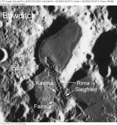
| − | <div style="margin-left: 1em">[#Karima Karima]</div><div style="margin-left: 2em">[#Karima-Images Images]</div><div style="margin-left: 2em">[#Karima-Maps Maps]</div><div style="margin-left: 2em">[#Karima-Description Description]</div><div style="margin-left: 2em">[#Karima-Description: Wikipedia Description: Wikipedia]</div><div style="margin-left: 2em">[#Karima-Additional Information Additional Information]</div><div style="margin-left: 2em">[#Karima-Nomenclature Nomenclature]</div><div style="margin-left: 2em">[#Karima-LPOD Articles LPOD Articles]</div><div style="margin-left: 2em">[#Karima-Bibliography Bibliography]</div></div>[http://www.lpod.org/coppermine/albums/userpics/Bowditch_AS15-M-2358_LTVT.JPG [[Image:normal_Bowditch_AS15-M-2358_LTVT.JPG|external image normal_Bowditch_AS15-M-2358_LTVT.JPG]]]<br /> ''[http://lpod.org/coppermine/displayimage.php?pos=-2505 AS15-M-2358]'' The area shown here is on the northwest shore of [ | + | <div style="margin-left: 1em">[#Karima Karima]</div><div style="margin-left: 2em">[#Karima-Images Images]</div><div style="margin-left: 2em">[#Karima-Maps Maps]</div><div style="margin-left: 2em">[#Karima-Description Description]</div><div style="margin-left: 2em">[#Karima-Description: Wikipedia Description: Wikipedia]</div><div style="margin-left: 2em">[#Karima-Additional Information Additional Information]</div><div style="margin-left: 2em">[#Karima-Nomenclature Nomenclature]</div><div style="margin-left: 2em">[#Karima-LPOD Articles LPOD Articles]</div><div style="margin-left: 2em">[#Karima-Bibliography Bibliography]</div></div>[http://www.lpod.org/coppermine/albums/userpics/Bowditch_AS15-M-2358_LTVT.JPG [[Image:normal_Bowditch_AS15-M-2358_LTVT.JPG|external image normal_Bowditch_AS15-M-2358_LTVT.JPG]]]<br /> ''[http://lpod.org/coppermine/displayimage.php?pos=-2505 AS15-M-2358]'' The area shown here is on the northwest shore of [[Lacus%20Solitudinis|Lacus Solitudinis]], between the craters [[Titius|Titius]] and [[Perel%27man|Perel'man]].<br /> In addition to the the dark-floored [[Bowditch|Bowditch]], the labels indicate several IAU-approved [[minor%20feature|minor feature]] names: [[Edith|Edith]], [[Bawa|Bawa]], [[Karima|Karima]], [[Fairouz|Fairouz]] and [[Rima%20Siegfried|Rima Siegfried]]. [[Bawa|Bawa]] is a pit along the west wall of [[Bowditch|Bowditch]]. It is completely in shadow in this view. <br /> <br /> |
==Images== | ==Images== | ||
[http://www.lpod.org/coppermine/thumbnails.php?album=search&type=full&search=Bowditch LPOD Photo Gallery] [http://www.lpi.usra.edu/resources/lunar_orbiter/bin/srch_nam.shtml?Bowditch%7C0 Lunar Orbiter Images] [http://www.lpi.usra.edu/resources/apollo/search/feature/?feature=Titius Apollo Images]<br /> <br /> | [http://www.lpod.org/coppermine/thumbnails.php?album=search&type=full&search=Bowditch LPOD Photo Gallery] [http://www.lpi.usra.edu/resources/lunar_orbiter/bin/srch_nam.shtml?Bowditch%7C0 Lunar Orbiter Images] [http://www.lpi.usra.edu/resources/apollo/search/feature/?feature=Titius Apollo Images]<br /> <br /> | ||
==Maps== | ==Maps== | ||
| − | ''([ | + | ''([[LAC%20zone|LAC zone]] 100C1)'' [http://www.lpi.usra.edu/resources/mapcatalog/LTO/lto100c1_2/ LTO map] [http://www.lpi.usra.edu/resources/mapcatalog/topophoto/100C1S1/ Topophotomap]<br /> <br /> |
==Description== | ==Description== | ||
<br /> | <br /> | ||
| Line 19: | Line 19: | ||
==Nomenclature== | ==Nomenclature== | ||
Arabic female name.<br /> | Arabic female name.<br /> | ||
| − | * According to [ | + | * According to [[NASA%20RP-1097|NASA RP-1097]], "Karima" is a [[Minor%20Feature|Minor Feature]] whose name was originally intended only for use in connection with [http://www.lpi.usra.edu/resources/mapcatalog/topophoto/100C1S1/ Topophotomap 100C1/S1](on which it is plotted). |
<br /> | <br /> | ||
==LPOD Articles== | ==LPOD Articles== | ||
Revision as of 14:54, 15 April 2018
Contents
Karima
| Lat: 25.9°S, Long: 103.0°E, Diam: 3 km, Depth: km, Rükl: (farside) |
Table of Contents
[#Karima Karima]
[#Karima-Images Images]
[#Karima-Maps Maps]
[#Karima-Description Description]
[#Karima-Description: Wikipedia Description: Wikipedia]
[#Karima-Additional Information Additional Information]
[#Karima-Nomenclature Nomenclature]
[#Karima-LPOD Articles LPOD Articles]
[#Karima-Bibliography Bibliography]

AS15-M-2358 The area shown here is on the northwest shore of Lacus Solitudinis, between the craters Titius and Perel'man.
In addition to the the dark-floored Bowditch, the labels indicate several IAU-approved minor feature names: Edith, Bawa, Karima, Fairouz and Rima Siegfried. Bawa is a pit along the west wall of Bowditch. It is completely in shadow in this view.
Images
LPOD Photo Gallery Lunar Orbiter Images Apollo Images
Maps
(LAC zone 100C1) LTO map Topophotomap
Description
Description: Wikipedia
Additional Information
Nomenclature
Arabic female name.
- According to NASA RP-1097, "Karima" is a Minor Feature whose name was originally intended only for use in connection with Topophotomap 100C1/S1(on which it is plotted).
LPOD Articles
Bibliography
This page has been edited 1 times. The last modification was made by - tychocrater tychocrater on Jun 13, 2009 3:24 pm - afx3u2