Difference between revisions of "Mare Australe"
| Line 6: | Line 6: | ||
|- | |- | ||
| | | | ||
| − | [http://www.lpod.org/coppermine/displayimage.php?pid=260&fullsize=1 [[Image: | + | [http://www.lpod.org/coppermine/displayimage.php?pid=260&fullsize=1 [[Image:Normal_MareAustrale060209.jpg|external image normal_MareAustrale060209.jpg]]]<br /> |
| | | | ||
| − | [http://lpod.org/coppermine/displayimage.php?pid=4682&fullsize=1 [[Image: | + | [http://lpod.org/coppermine/displayimage.php?pid=4682&fullsize=1 [[Image:Normal_australe1.jpg|external image normal_australe1.jpg]]]<br /> |
| | | | ||
| − | [http://www.lpod.org/coppermine/displayimage.php?pid=2313&fullsize=1 [[Image: | + | [http://www.lpod.org/coppermine/displayimage.php?pid=2313&fullsize=1 [[Image:Normal_Australe_Basin_LIDAR_LTVT.JPG|external image normal_Australe_Basin_LIDAR_LTVT.JPG]]]<br /> |
|} | |} | ||
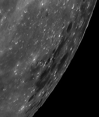
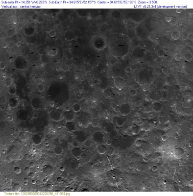
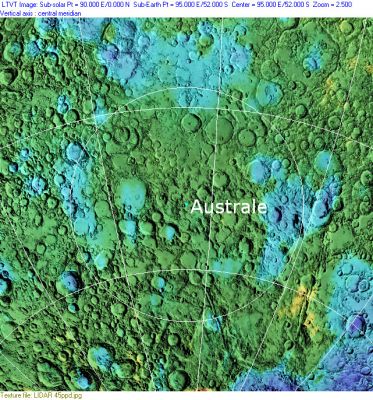
'''Left''': ''[http://lpod.org/coppermine/displayimage.php?pos=-260 Peter Lloyd]'', this image shows the western part of the basin area indicated in the right-hand image, and the terrain to its west. Most of this is ''not'' part of '''Mare Australe'''. Only the southwestern quadrant of the IAU's present '''Mare Australe''' is visible in the extreme upper right. The prominent dark-floored crater near the top is [http://the-moon.us/wiki/Oken Oken], and the larger one below it and closer to the limb is [http://the-moon.us/wiki/Lyot Lyot] -- see Peter's [http://www.madpc.co.uk/~peterl/Moon/Craters/MAustrale.html mouseover] image for clearer identifications. These craters fall within the presumed impact basin, but outside '''Mare Australe''' (as currently defined by the IAU).<br /> '''Middle''': Aerial view of the basin using ''[http://ltvt.wikispaces.com/LTVT LTVT]'' on a ''[http://www.mapaplanet.org/explorer-bin/explorer.cgi?map=Moon&layers=moon_clementine_base_v2&west=520&south=1086&east=1002&north=646¢er=90.75¢er_lat=0&defaultcenter=on&grid=none&stretch=auto&resamp_method=nearest_neighbor&projection=SIMP&r=1&g=1&b=1&advoption=NO&info=NO&resolution=8&lines=1160&samples=1452&scale=3.79041&imageTopX=-2749948.8853216171&imageTopY=1673469.9281454086&box=yes&x=996&y=1080 Clementine]'' view from ''[http://www.mapaplanet.org/ Map-A-Planet]''.<br /> '''Right''': ''[http://lpod.org/coppermine/displayimage.php?pos=-2313 Clementine]'', the '''Australe Impact Basin''' as illustrated by the Clementine LIDAR Altimeter texture from [http://pdsmaps.wr.usgs.gov/PDS/public/explorer/html/lidrlvls.htm PDS Map-a-Planet] remapped to north-up aerial view by [http://www.henriksucla.dk/ LTVT]. The dot is the center position and the white circle the main ring position from Chuck Wood's [http://www.lpod.org/cwm/DataStuff/Lunar%20Basins.htm Impact Basin Database]. Grid spacing = 10 degrees. This interpretation of the impact basin has a significantly different center from the IAU's '''Mare Australe'''.<br /> <br /> <div id="toc"> | '''Left''': ''[http://lpod.org/coppermine/displayimage.php?pos=-260 Peter Lloyd]'', this image shows the western part of the basin area indicated in the right-hand image, and the terrain to its west. Most of this is ''not'' part of '''Mare Australe'''. Only the southwestern quadrant of the IAU's present '''Mare Australe''' is visible in the extreme upper right. The prominent dark-floored crater near the top is [http://the-moon.us/wiki/Oken Oken], and the larger one below it and closer to the limb is [http://the-moon.us/wiki/Lyot Lyot] -- see Peter's [http://www.madpc.co.uk/~peterl/Moon/Craters/MAustrale.html mouseover] image for clearer identifications. These craters fall within the presumed impact basin, but outside '''Mare Australe''' (as currently defined by the IAU).<br /> '''Middle''': Aerial view of the basin using ''[http://ltvt.wikispaces.com/LTVT LTVT]'' on a ''[http://www.mapaplanet.org/explorer-bin/explorer.cgi?map=Moon&layers=moon_clementine_base_v2&west=520&south=1086&east=1002&north=646¢er=90.75¢er_lat=0&defaultcenter=on&grid=none&stretch=auto&resamp_method=nearest_neighbor&projection=SIMP&r=1&g=1&b=1&advoption=NO&info=NO&resolution=8&lines=1160&samples=1452&scale=3.79041&imageTopX=-2749948.8853216171&imageTopY=1673469.9281454086&box=yes&x=996&y=1080 Clementine]'' view from ''[http://www.mapaplanet.org/ Map-A-Planet]''.<br /> '''Right''': ''[http://lpod.org/coppermine/displayimage.php?pos=-2313 Clementine]'', the '''Australe Impact Basin''' as illustrated by the Clementine LIDAR Altimeter texture from [http://pdsmaps.wr.usgs.gov/PDS/public/explorer/html/lidrlvls.htm PDS Map-a-Planet] remapped to north-up aerial view by [http://www.henriksucla.dk/ LTVT]. The dot is the center position and the white circle the main ring position from Chuck Wood's [http://www.lpod.org/cwm/DataStuff/Lunar%20Basins.htm Impact Basin Database]. Grid spacing = 10 degrees. This interpretation of the impact basin has a significantly different center from the IAU's '''Mare Australe'''.<br /> <br /> <div id="toc"> | ||
Revision as of 20:44, 15 April 2018
Contents
Australe Basin
(unofficial name; IAU feature name for central 603 km of mare: Mare Australe )
| IAU Lat: 38.9°S, Long: 93.0°E; Basin main ring diam: 880 km, Depth: 2.13 km, Rükl: Libration Zones IV (CURIE) and V (HALE) | ||
Middle: Aerial view of the basin using LTVT on a Clementine view from Map-A-Planet.
Right: Clementine, the Australe Impact Basin as illustrated by the Clementine LIDAR Altimeter texture from PDS Map-a-Planet remapped to north-up aerial view by LTVT. The dot is the center position and the white circle the main ring position from Chuck Wood's Impact Basin Database. Grid spacing = 10 degrees. This interpretation of the impact basin has a significantly different center from the IAU's Mare Australe.
Images
LPOD Photo Gallery Lunar Orbiter Images Apollo Images
- Mare Australe as photographed by the crew of Apollo 15: AS15-88-12008. It is one of the last images in Apollo 15's Hasselblad-magazine 88/TT. Note the curious bluish "U"-shaped reflections.- DannyCaes Sep 29, 2013
Maps
(LAC zone 116A3) USGS Digital Atlas PDF
Basin Classification
(description of terms and most numeric basin data from Wood, C.A. (2004) Impact Basin Database)
| Certainty of Existence |
USGS Age |
Wilhelms Age Group |
Ring Diameters |
Mare Thickness |
Mascon |
| Probable |
Pre-Nectarian |
3 |
550, 880 km |
1.3 km |
No, 30 mG gravity anomanly |
Note: This feature is not listed in Hartmann and Wood, 1971. The center of the circle appearing in the illustration at the top of this page is placed at 52°S/95°E, which is the center position indicated in the Impact Basin Database. The source of that position is unknown.
Description
Wikipedia
Additional Information
- Mare area of 319,000 km^2 according to measurements by Jim Whitford-Stark.
- Rim Height 140 m
- First described as an impact basin by Stewart-Alexander & Howard (1970). The center was given as 44°S/90°E and the diameter as 900 km.
- The IAU official coordinates for the central region of this basin are: - Lat 47.77°S, Long: 91.99°E, Diameter 996.84 km. - JohnMoore2 JohnMoore2
Nomenclature
- The IAU name is Latin for "Southern Sea".
- The impact basin is named for the mare.
- According to Whitaker (p. 219), the name Mare Australe was introduced by Mädler.
- The exact area that is designated by the IAU name is vaguely defined and has changed appreciably over the years. This feature was Catalog Number 4531 in Mary Blagg's Collated List, and its orginal position in Blagg and Müller was apparently 43°S/77°E. In the later System of Lunar Craters, it appears on maps A7 and B8, where it extends roughly from Oken to Hanno, with an apparent center at about 52°S/75°E. Sometime later, the IAU seems to have adopted the positions and diameters listed in Gazetteer of Planetary Nomenclature, which do not necessarily agree with the previous IAU data. The position and diameter listed on the title line are those from the current official on-line IAU Gazetteer. This defines a circle which extends roughly from Abel to Lamb and from Hamilton to Donner. The craters Oken and Lyot fall outside the present boundary. This vagueness of definition and drifting position is similar to that experienced by Sinus Roris. - Jim Mosher
LROC Articles
LPOD Articles
Lunar 100
L56: A partially flooded ancient basin.
Bibliography
- Gillis, JJ & BL Jolliff (2002). An analysis of remotely sensed data of Mare Australe. Abstracts, Workshop on the Moon Beyond 2002, 3025.
- Whitford-Stark, JL (1979). Charting the southern seas: The evolution of the lunar Mare Australe. Proc. 10th Lunar Planet. Sci. Conf., 2975-2994Proc. 10th Lunar Planet. Sci. Conf., 2975-2994.
- Wood, C.A. 20__. Australe: A Mare on the Edge. S&T Online Article.
- Wood, C.A. 5/2006. Extreme Basinology. S&T 111(5):58-59
- Wood, C.A. Aug. 2002. Australe: A Mare on the Edge. S&T August 2002 v104 p126
- Apollo Over the Moon, Chapter 2: Regional views, Figure 21 (Mare Australe at horizon, Lauritsen in the foreground).


