Difference between revisions of "Schrödinger"
(Created page with "<div id="content_view" class="wiki" style="display: block"> =Schrödinger Basin= ''(unofficial name; IAU crater name: '''Schrödinger'''; 312 km diam)''<br /> {| class="wi...") |
|||
| (One intermediate revision by the same user not shown) | |||
| Line 5: | Line 5: | ||
| Lat: 75.0°S, Long: 132.4°E, Main ring diam: 320 km, Depth: 4.8 km, Rükl: ''(farside)''<br /> | | Lat: 75.0°S, Long: 132.4°E, Main ring diam: 320 km, Depth: 4.8 km, Rükl: ''(farside)''<br /> | ||
|} | |} | ||
| − | [http://www.lpod.org/coppermine/displayimage.php?pid=909&fullsize=1 [[Image: | + | [http://www.lpod.org/coppermine/displayimage.php?pid=909&fullsize=1 [[Image:Normal_schrodinger-clem1.jpg|external image normal_schrodinger-clem1.jpg]]][http://www.lpod.org/coppermine/displayimage.php?pid=2348&fullsize=1 [[Image:Normal_Schrodinger_Basin_LIDAR_LTVT.JPG|external image normal_Schrodinger_Basin_LIDAR_LTVT.JPG]]]<br /> '''Left:''' ''[http://lpod.org/coppermine/displayimage.php?pos=-909 Clementine]''.<br /> '''Right:''' ''[http://lpod.org/coppermine/displayimage.php?pos=-2348 Clementine]'', Clementine LIDAR Altimeter texture from [http://pdsmaps.wr.usgs.gov/PDS/public/explorer/html/lidrlvls.htm PDS Map-a-Planet] remapped to north-up aerial view by [http://www.henriksucla.dk/ LTVT]. The dot is the center position and the white circle the main ring position from Chuck Wood's [http://www.lpod.org/cwm/DataStuff/Lunar%20Basins.htm Impact Basin Database]. Grid spacing = 10 degrees.<br /> <div id="toc"> |
| − | + | ||
| − | |||
==Images== | ==Images== | ||
[http://www.lpod.org/coppermine/thumbnails.php?album=search&type=full&search=Schrodinger LPOD Photo Gallery] [http://www.lpi.usra.edu/resources/lunar_orbiter/bin/srch_nam.shtml?Schrodinger%7C0 Lunar Orbiter Images] [http://www.lpi.usra.edu/resources/apollo/search/feature/?feature=Schrodinger Apollo Images] [http://jda.jaxa.jp/jda/p4_e.php?f_id=15970&mode=level&time=N&genre=5&category=5025 Kaguya HDTV]<br /> | [http://www.lpod.org/coppermine/thumbnails.php?album=search&type=full&search=Schrodinger LPOD Photo Gallery] [http://www.lpi.usra.edu/resources/lunar_orbiter/bin/srch_nam.shtml?Schrodinger%7C0 Lunar Orbiter Images] [http://www.lpi.usra.edu/resources/apollo/search/feature/?feature=Schrodinger Apollo Images] [http://jda.jaxa.jp/jda/p4_e.php?f_id=15970&mode=level&time=N&genre=5&category=5025 Kaguya HDTV]<br /> | ||
| Line 40: | Line 39: | ||
* Exterior impact melt deposits to E, max of ~100 km beyond rim. Most extensive ejecta, rays and secondary craters to the NE, with max wall slumping on E side of crater, and topographically lowest rim crest to S ([[Hawke%20and%20Head%2C%201977|Hawke and Head, 1977]]). | * Exterior impact melt deposits to E, max of ~100 km beyond rim. Most extensive ejecta, rays and secondary craters to the NE, with max wall slumping on E side of crater, and topographically lowest rim crest to S ([[Hawke%20and%20Head%2C%201977|Hawke and Head, 1977]]). | ||
* Mare area of 1,325 km^2 according to measurements by [http://www.lpod.org/cwm/DataStuff/MareAreas.htm Jim Whitford-Stark]. | * Mare area of 1,325 km^2 according to measurements by [http://www.lpod.org/cwm/DataStuff/MareAreas.htm Jim Whitford-Stark]. | ||
| − | * East of '''Schrödinger''' (between '''Schrödinger''' and [[De%20Forest|De Forest]], see [[Clementine%20Atlas|Clementine]]'s photographs of it on LAC 141) is an irregular shaped valley of which the most pronounced (and most shadowed) part is located at 165° to 170° East, 77° South. <span class="membersnap">- | + | * East of '''Schrödinger''' (between '''Schrödinger''' and [[De%20Forest|De Forest]], see [[Clementine%20Atlas|Clementine]]'s photographs of it on LAC 141) is an irregular shaped valley of which the most pronounced (and most shadowed) part is located at 165° to 170° East, 77° South. <span class="membersnap">- DannyCaes <small>May 12, 2009</small></span> |
| − | * The odd crater '''Schrodinger W''', northwest of '''Schrodinger''' itself, looks a bit like one of the craters of the '''Messier''' pair in '''Mare Fecunditatis'''. A large crater is overlapping a little one, or are both the result of one single oblique impact? <span class="membersnap">- | + | * The odd crater '''Schrodinger W''', northwest of '''Schrodinger''' itself, looks a bit like one of the craters of the '''Messier''' pair in '''Mare Fecunditatis'''. A large crater is overlapping a little one, or are both the result of one single oblique impact? <span class="membersnap">- DannyCaes <small>Aug 13, 2014</small></span> |
<br /> | <br /> | ||
==Nomenclature== | ==Nomenclature== | ||
| Line 61: | Line 60: | ||
<br /> <br /> | <br /> <br /> | ||
---- | ---- | ||
| − | + | </div> | |
Latest revision as of 02:16, 16 April 2018
Contents
Schrödinger Basin
(unofficial name; IAU crater name: Schrödinger; 312 km diam)
| Lat: 75.0°S, Long: 132.4°E, Main ring diam: 320 km, Depth: 4.8 km, Rükl: (farside) |


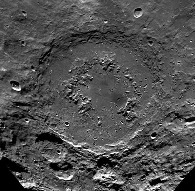
Left: Clementine.
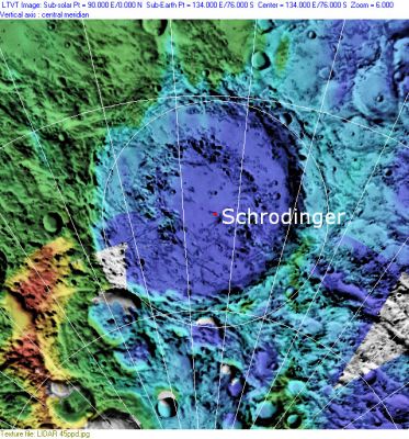
Right: Clementine, Clementine LIDAR Altimeter texture from PDS Map-a-Planet remapped to north-up aerial view by LTVT. The dot is the center position and the white circle the main ring position from Chuck Wood's Impact Basin Database. Grid spacing = 10 degrees.
Images
LPOD Photo Gallery Lunar Orbiter Images Apollo Images Kaguya HDTV
- Clementine close-up of the dark-haloed crater on the floor of Schrödinger
Maps
(LAC zone 140C1) USGS Digital Atlas PDF
Basin Classification
(description of terms and most numeric basin data from Wood, C.A. (2004) Impact Basin Database)
| Certainty of Existence |
USGS Age |
Wilhelms Age Group |
Ring Diameters |
Mare Thickness |
Mascon |
| Certain |
Imbrian |
12 |
150, 320 km |
Description
Wikipedia
Additional Information
- Exterior impact melt deposits to E, max of ~100 km beyond rim. Most extensive ejecta, rays and secondary craters to the NE, with max wall slumping on E side of crater, and topographically lowest rim crest to S (Hawke and Head, 1977).
- Mare area of 1,325 km^2 according to measurements by Jim Whitford-Stark.
- East of Schrödinger (between Schrödinger and De Forest, see Clementine's photographs of it on LAC 141) is an irregular shaped valley of which the most pronounced (and most shadowed) part is located at 165° to 170° East, 77° South. - DannyCaes May 12, 2009
- The odd crater Schrodinger W, northwest of Schrodinger itself, looks a bit like one of the craters of the Messier pair in Mare Fecunditatis. A large crater is overlapping a little one, or are both the result of one single oblique impact? - DannyCaes Aug 13, 2014
Nomenclature
- The IAU crater name honors Erwin Rudolf Josef Alexander Schrödinger (August 12, 1887 – January 4, 1961) an Austrian-Irish physicist who achieved fame for his contributions to quantum mechanics, especially the Schrödinger equation, for which he received the Nobel Prize in 1933. In 1935, he proposed the Schrödinger's cat thought experiment.
- The impact basin is named after the crater.
- The pronounced valley between Schrödinger and De Forest is unofficially called Vallis Schrödinger-De Forest by D.Caes.
- Rimae Schrodinger (an unofficial name from D.Caes for the impressive system of rilles on the floor of Schrodinger).
LPOD Articles
Bibliography
- Kramer, G. Y. et al(2011). Analysis of Schrodinger Basin Using Moon Mineralogy Mapper Spectra – 42nd LPSC Conference (Mar), 2011.
- Shoemaker, E.M., M.S. Robinson & E.M. Eliason (1994) The South Pole region of the Moon as seen by Clementine. Science 266, 1851-1854.
- T. Kohout, K. O’Sullivan, A. Losiak, K. G. Thaisen, S. Weider and D. A. Kring (2009) Scientific Opportunities for Human Exploration of the Moon’s Schrödinger Basin LPSC 40th #1572.