Difference between revisions of "Sinus Asperitatis"
| (2 intermediate revisions by the same user not shown) | |||
| Line 3: | Line 3: | ||
{| class="wiki_table" | {| class="wiki_table" | ||
| | | | ||
| − | Lat: 3.8°S, Long: 27.4°E, Diam: 206 km, Depth: km, [ | + | Lat: 3.8°S, Long: 27.4°E, Diam: 206 km, Depth: km, [[R%C3%BCkl%2047|Rükl: 47]]<br /> |
|} | |} | ||
<div id="toc"> | <div id="toc"> | ||
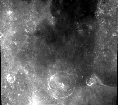
| − | + | [http://www.lpod.org/coppermine/displayimage.php?pid=543&fullsize=1 [[Image:Normal_sinus-asperitatis-clem1.jpg|external image normal_sinus-asperitatis-clem1.jpg]]]<br /> ''[http://lpod.org/coppermine/displayimage.php?pos=-543 Clementine]''<br /> The pronounced crater near the lower margin of this ''Clementine'' photograph is '''Theophilus'''.<br /> <br /> | |
| − | |||
==Images== | ==Images== | ||
[http://www.lpod.org/coppermine/thumbnails.php?album=search&type=full&search=Sinus%20Asperitatis LPOD Photo Gallery] [http://www.lpi.usra.edu/resources/lunar_orbiter/bin/srch_nam.shtml?Sinus%20Asperitatis%7C0 Lunar Orbiter Images] [http://www.lpi.usra.edu/resources/apollo/search/feature/?feature=Sinus%20Asperitatis Apollo Images] (the name '''Sinus Asperitatis''' is not mentioned in the search engine of the ''Apollo Image Atlas'') (to compile an additional list of orbital Apollo photographs of this region north of '''Theophilus''' would be interesting).<br /> <br /> | [http://www.lpod.org/coppermine/thumbnails.php?album=search&type=full&search=Sinus%20Asperitatis LPOD Photo Gallery] [http://www.lpi.usra.edu/resources/lunar_orbiter/bin/srch_nam.shtml?Sinus%20Asperitatis%7C0 Lunar Orbiter Images] [http://www.lpi.usra.edu/resources/apollo/search/feature/?feature=Sinus%20Asperitatis Apollo Images] (the name '''Sinus Asperitatis''' is not mentioned in the search engine of the ''Apollo Image Atlas'') (to compile an additional list of orbital Apollo photographs of this region north of '''Theophilus''' would be interesting).<br /> <br /> | ||
==Maps== | ==Maps== | ||
| − | ''([ | + | ''([[LAC%20zone|LAC zone]] 78B2)'' [http://www.lpi.usra.edu/resources/mapcatalog/LAC/lac78/ LAC map] [http://www.lpi.usra.edu/resources/mapcatalog/usgs/I546/ Geologic map] [http://www.lpi.usra.edu/resources/mapcatalog/LM/lm78/ LM map] [http://www.lpi.usra.edu/resources/mapcatalog/AIC/AIC78B/ AIC map]<br /> <br /> |
==Description== | ==Description== | ||
<br /> | <br /> | ||
| Line 17: | Line 16: | ||
[http://en.wikipedia.org/wiki/Sinus_Asperitatis Sinus Asperitatis]<br /> <br /> | [http://en.wikipedia.org/wiki/Sinus_Asperitatis Sinus Asperitatis]<br /> <br /> | ||
==Additional Information== | ==Additional Information== | ||
| − | * A somewhat fork- or branch-shaped [ | + | * A somewhat fork- or branch-shaped [[rima|rille]] at 6°20' South/ 24°30' East (between [[Theophilus|Theophilus]] and [[Hypatia|Hypatia]], in '''Sinus Asperitatis'''), is described and depicted in NASA SP-362, APOLLO OVER THE MOON; A VIEW FROM ORBIT, Chapter 5: Craters ([http://www.hq.nasa.gov/office/pao/History/SP-362/ch5.3.htm Part 3]), Figure 136. Detection of this rille's exact location: Danny Caes. |
<br /> | <br /> | ||
==Nomenclature== | ==Nomenclature== | ||
| − | * The [ | + | * The [[IAU|IAU]] name is Latin for "Bay of Roughness". |
| − | * This name was not part of the original [ | + | * This name was not part of the original [[IAU%20nomenclature|IAU nomenclature]]. It is one of the 120 names on [[LTO|LTO]] charts approved by the [[IAU|IAU]] in [http://the-moon.us/wiki/IAU%20Transactions%20XVIB 1976] |
* Perhaps interesting to add something in here about a certain terrestrial cloud formation called [https://en.wikipedia.org/wiki/Asperitas_(cloud) Asperitas], and also about one of the early observers and photographers of this cloud formation''':''' [https://en.wikipedia.org/wiki/Margaret_Anne_LeMone Margaret Anne LeMone] | * Perhaps interesting to add something in here about a certain terrestrial cloud formation called [https://en.wikipedia.org/wiki/Asperitas_(cloud) Asperitas], and also about one of the early observers and photographers of this cloud formation''':''' [https://en.wikipedia.org/wiki/Margaret_Anne_LeMone Margaret Anne LeMone] | ||
<br /> | <br /> | ||
| Line 30: | Line 29: | ||
<br /> <br /> | <br /> <br /> | ||
---- | ---- | ||
| − | + | </div> | |
Latest revision as of 20:45, 15 April 2018
Contents
Sinus Asperitatis
|
Lat: 3.8°S, Long: 27.4°E, Diam: 206 km, Depth: km, Rükl: 47 |

Clementine
The pronounced crater near the lower margin of this Clementine photograph is Theophilus.
Images
LPOD Photo Gallery Lunar Orbiter Images Apollo Images (the name Sinus Asperitatis is not mentioned in the search engine of the Apollo Image Atlas) (to compile an additional list of orbital Apollo photographs of this region north of Theophilus would be interesting).
Maps
(LAC zone 78B2) LAC map Geologic map LM map AIC map
Description
Description: Wikipedia
Additional Information
- A somewhat fork- or branch-shaped rille at 6°20' South/ 24°30' East (between Theophilus and Hypatia, in Sinus Asperitatis), is described and depicted in NASA SP-362, APOLLO OVER THE MOON; A VIEW FROM ORBIT, Chapter 5: Craters (Part 3), Figure 136. Detection of this rille's exact location: Danny Caes.
Nomenclature
- The IAU name is Latin for "Bay of Roughness".
- This name was not part of the original IAU nomenclature. It is one of the 120 names on LTO charts approved by the IAU in 1976
- Perhaps interesting to add something in here about a certain terrestrial cloud formation called Asperitas, and also about one of the early observers and photographers of this cloud formation: Margaret Anne LeMone
LPOD Articles
Ring Around a Basin Another kind of melt
Almost Microgeology (George Tarsoudis's pre-sunset photograph of the Hypatia-Torricelli-Theophilus region)
Bibliography