Difference between revisions of "Planck"
| (One intermediate revision by the same user not shown) | |||
| Line 5: | Line 5: | ||
| Lat: 57.9°S, Long: 136.8°E, Main ring diam: 325 km, Depth: 4.0 km, Rükl: ''(farside)''<br /> | | Lat: 57.9°S, Long: 136.8°E, Main ring diam: 325 km, Depth: 4.0 km, Rükl: ''(farside)''<br /> | ||
|} | |} | ||
| − | [http://www.lpod.org/coppermine/displayimage.php?pid=1072&fullsize=1 [[Image: | + | [http://www.lpod.org/coppermine/displayimage.php?pid=1072&fullsize=1 [[Image:Normal_planck-clem1.jpg|external image normal_planck-clem1.jpg]]][http://www.lpod.org/coppermine/displayimage.php?pid=2341&fullsize=1 [[Image:Normal_Planck_Basin_LIDAR_LTVT.JPG|external image normal_Planck_Basin_LIDAR_LTVT.JPG]]]<br /> Left: ''[http://lpod.org/coppermine/displayimage.php?pos=-1072 Clementine]'', Right: ''[http://lpod.org/coppermine/displayimage.php?pos=-2341 Clementine]'', Clementine LIDAR Altimeter texture from [http://pdsmaps.wr.usgs.gov/PDS/public/explorer/html/lidrlvls.htm PDS Map-a-Planet] remapped to north-up aerial view by [http://www.henriksucla.dk/ LTVT]. The dot is the center position and the white circle the main ring position from Chuck Wood's [http://www.lpod.org/cwm/DataStuff/Lunar%20Basins.htm Impact Basin Database]. Grid spacing = 10 degrees.<br /> <br /> <div id="toc"> |
| − | + | ||
| − | |||
==Images== | ==Images== | ||
[http://www.lpod.org/coppermine/thumbnails.php?album=search&type=full&search=Planck LPOD Photo Gallery] [http://www.lpi.usra.edu/resources/lunar_orbiter/bin/srch_nam.shtml?Planck%7C0 Lunar Orbiter Images] [http://www.lpi.usra.edu/resources/apollo/search/feature/?feature=Planck Apollo Images]<br /> <br /> | [http://www.lpod.org/coppermine/thumbnails.php?album=search&type=full&search=Planck LPOD Photo Gallery] [http://www.lpi.usra.edu/resources/lunar_orbiter/bin/srch_nam.shtml?Planck%7C0 Lunar Orbiter Images] [http://www.lpi.usra.edu/resources/apollo/search/feature/?feature=Planck Apollo Images]<br /> <br /> | ||
| Line 42: | Line 41: | ||
* In preparing the list of farside names using space-based overhead photography, the IAU Working Group for Lunar Nomenclature was unable to find evidence of a significant crater at that location, and chose to delete the 1964 approval and re-assign the name to the present crater ([http://the-moon.us/wiki/Menzel%2C%201971 Menzel, 1971]). | * In preparing the list of farside names using space-based overhead photography, the IAU Working Group for Lunar Nomenclature was unable to find evidence of a significant crater at that location, and chose to delete the 1964 approval and re-assign the name to the present crater ([http://the-moon.us/wiki/Menzel%2C%201971 Menzel, 1971]). | ||
* On the greyish light-blue farside map of Patrick Moore's ''Atlas of the Universe'' (edition 1970), the name '''Planck''' (and also the name [http://the-moon.us/wiki/Fermi Fermi]) was printed at the ''[http://the-moon.us/wiki/Rectified%20Lunar%20Atlas Rectified Lunar Atlas]'' location, near craters [http://the-moon.us/wiki/Bohr Bohr] and [http://the-moon.us/wiki/Sundman Sundman]). Research Danny Caes. | * On the greyish light-blue farside map of Patrick Moore's ''Atlas of the Universe'' (edition 1970), the name '''Planck''' (and also the name [http://the-moon.us/wiki/Fermi Fermi]) was printed at the ''[http://the-moon.us/wiki/Rectified%20Lunar%20Atlas Rectified Lunar Atlas]'' location, near craters [http://the-moon.us/wiki/Bohr Bohr] and [http://the-moon.us/wiki/Sundman Sundman]). Research Danny Caes. | ||
| − | * What appears to be an officially unnamed large crater northwest of '''Planck''' (at 127 degrees East/ 52 degrees South, see the upper right corner of LAC 130) looks quite distinct on the farside map of ''Hallwag''. <span class="membersnap">- | + | * What appears to be an officially unnamed large crater northwest of '''Planck''' (at 127 degrees East/ 52 degrees South, see the upper right corner of LAC 130) looks quite distinct on the farside map of ''Hallwag''. <span class="membersnap">- DannyCaes <small>Feb 13, 2012</small></span> |
<br /> | <br /> | ||
==LPOD Articles== | ==LPOD Articles== | ||
| Line 49: | Line 48: | ||
<br /> <br /> | <br /> <br /> | ||
---- | ---- | ||
| − | + | </div> | |
Latest revision as of 02:09, 16 April 2018
Contents
Planck Basin
(unofficial name; IAU crater name: Planck; 314 km diam)
| Lat: 57.9°S, Long: 136.8°E, Main ring diam: 325 km, Depth: 4.0 km, Rükl: (farside) |


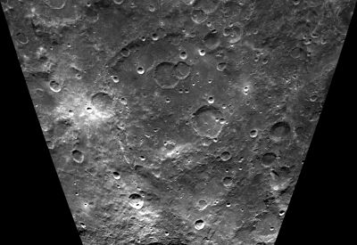
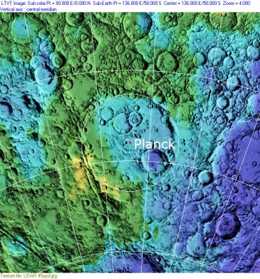
Left: Clementine, Right: Clementine, Clementine LIDAR Altimeter texture from PDS Map-a-Planet remapped to north-up aerial view by LTVT. The dot is the center position and the white circle the main ring position from Chuck Wood's Impact Basin Database. Grid spacing = 10 degrees.
Images
LPOD Photo Gallery Lunar Orbiter Images Apollo Images
Maps
(LAC zone 131D1) USGS Digital Atlas PDF
Basin Classification
(description of terms and most numeric basin data from Wood, C.A. (2004) Impact Basin Database)
| Certainty of Existence |
USGS Age |
Wilhelms Age Group |
Ring Diameters |
Mare Thickness |
Mascon |
| Probable |
Pre-Nectarian |
7 |
160, 325 km |
Description
Description: Wikipedia
Additional Information
Nomenclature
- The IAU crater name honors Max Karl Ernst Ludwig Planck (April 23, 1858 – October 4, 1947), a German physicist and Nobel laureate. He is considered to be the founder of quantum theory, and therefore one of the most important physicists of the twentieth century. Planck was among the few who immediately recognized the significance of the special theory of relativity. Thanks to his influence this theory was soon widely accepted in Germany. Planck also contributed considerably to extend the special theory of relativity.
- The impact basin is named after the crater.
- This name Planck was introduced into lunar nomenclature in the Rectified Lunar Atlas (1963), based on Earth-based photos of the libration zones. It was there assigned to a 78 km diameter crater centered at 87.0° W/ 8.0° N. That assignment was approved by the IAU in 1964.
- In preparing the list of farside names using space-based overhead photography, the IAU Working Group for Lunar Nomenclature was unable to find evidence of a significant crater at that location, and chose to delete the 1964 approval and re-assign the name to the present crater (Menzel, 1971).
- On the greyish light-blue farside map of Patrick Moore's Atlas of the Universe (edition 1970), the name Planck (and also the name Fermi) was printed at the Rectified Lunar Atlas location, near craters Bohr and Sundman). Research Danny Caes.
- What appears to be an officially unnamed large crater northwest of Planck (at 127 degrees East/ 52 degrees South, see the upper right corner of LAC 130) looks quite distinct on the farside map of Hallwag. - DannyCaes Feb 13, 2012
LPOD Articles
Bibliography