Difference between revisions of "Capella Rilles"
(Created page with "<div id="content_view" class="wiki" style="display: block"> =Capella Rilles= ''(discontinued IAU names)''<br /> {| class="wiki_table" | Lat: 4.8°S, Long: 36.5°E, Lengt...") |
|||
| (2 intermediate revisions by the same user not shown) | |||
| Line 4: | Line 4: | ||
{| class="wiki_table" | {| class="wiki_table" | ||
| | | | ||
| − | Lat: 4.8°S, Long: 36.5°E, Length: 150 km, Depth: km, [ | + | Lat: 4.8°S, Long: 36.5°E, Length: 150 km, Depth: km, [[R%C3%BCkl%2047|Rükl: 47]]<br /> |
|} | |} | ||
<div id="toc"> | <div id="toc"> | ||
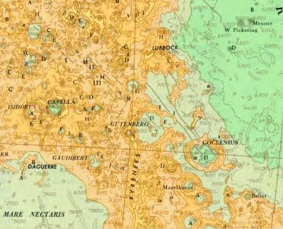
| − | + | [http://www.lpod.org/coppermine/albums/userpics/Goclenius_Gutenberg_Capella_rilles_LTM_Sheet_1.jpg [[Image:Normal_Goclenius_Gutenberg_Capella_rilles_LTM_Sheet_1.jpg|external image normal_Goclenius_Gutenberg_Capella_rilles_LTM_Sheet_1.jpg]]]<br /> ''[http://lpod.org/coppermine/displayimage.php?pos=-1929 Army Map Service]'' The three '''Capella rilles''' of ''[[Named%20Lunar%20Formations|Named Lunar Formations]]'' (I, II and III) are to the northeast of [[Capella|Capella]], near '''[[Capella|Capella]] M'''.<br /> <br /> | |
| − | |||
==Images== | ==Images== | ||
[http://www.lpod.org/coppermine/thumbnails.php?album=search&type=full&search=Capella LPOD Photo Gallery] [http://www.lpi.usra.edu/resources/lunar_orbiter/bin/srch_nam.shtml?Capella%7C0 Lunar Orbiter Images] [http://www.lpi.usra.edu/resources/apollo/search/feature/?feature=Capella Apollo Images]<br /> <br /> | [http://www.lpod.org/coppermine/thumbnails.php?album=search&type=full&search=Capella LPOD Photo Gallery] [http://www.lpi.usra.edu/resources/lunar_orbiter/bin/srch_nam.shtml?Capella%7C0 Lunar Orbiter Images] [http://www.lpi.usra.edu/resources/apollo/search/feature/?feature=Capella Apollo Images]<br /> <br /> | ||
==Maps== | ==Maps== | ||
| − | ''([ | + | ''([[LAC%20zone|LAC zone]] 79A3)'' [http://www.lpi.usra.edu/resources/mapcatalog/LAC/lac79/ LAC map] [http://www.lpi.usra.edu/resources/mapcatalog/usgs/I714/ Geologic map] [http://www.lpi.usra.edu/resources/mapcatalog/AIC/AIC79A/ AIC map] [http://www.lpi.usra.edu/resources/mapcatalog/LTO/lto79a3_1/ LTO map]<br /> <br /> |
==Description== | ==Description== | ||
<br /> | <br /> | ||
| Line 18: | Line 17: | ||
<br /> | <br /> | ||
==Nomenclature== | ==Nomenclature== | ||
| − | * Named after nearby the crater ([ | + | * Named after nearby the crater ([[Capella|Capella]]). |
| − | * The original [ | + | * The original [[IAU%20nomenclature|IAU nomenclature]] of [[Blagg%20and%20M%C3%BCller|Blagg and Müller]] contained three rilles named after [[Capella|Capella]] (Catalog entries 4280, 4281 and 4283). The designations are attributed to Mädler. |
| − | * The ''[ | + | * The ''[[System%20of%20Lunar%20Craters|System of Lunar Craters]]'' made '''Capella Ir''', '''IIr''' and '''IIIr''' part of [[Rimae%20Gutenberg|Rimae Gutenberg]]. |
<br /> | <br /> | ||
==LPOD Articles== | ==LPOD Articles== | ||
| Line 27: | Line 26: | ||
<br /> | <br /> | ||
---- | ---- | ||
| − | + | </div> | |
Latest revision as of 01:43, 16 April 2018
Contents
Capella Rilles
(discontinued IAU names)
|
Lat: 4.8°S, Long: 36.5°E, Length: 150 km, Depth: km, Rükl: 47 |

Army Map Service The three Capella rilles of Named Lunar Formations (I, II and III) are to the northeast of Capella, near Capella M.
Images
LPOD Photo Gallery Lunar Orbiter Images Apollo Images
Maps
(LAC zone 79A3) LAC map Geologic map AIC map LTO map
Description
Additional Information
Nomenclature
- Named after nearby the crater (Capella).
- The original IAU nomenclature of Blagg and Müller contained three rilles named after Capella (Catalog entries 4280, 4281 and 4283). The designations are attributed to Mädler.
- The System of Lunar Craters made Capella Ir, IIr and IIIr part of Rimae Gutenberg.
LPOD Articles
Bibliography